


<< Text Pages >> The Kingship Stone, Cherry Hinton - Natural Stone / Erratic / Other Natural Feature in England in Cambridgeshire
Submitted by Andy B on Wednesday, 08 September 2010 Page Views: 8413
Natural PlacesSite Name: The Kingship Stone, Cherry Hinton Alternative Name: Robin Hood and Little John PubCountry: England
NOTE: This site is 3.67 km away from the location you searched for.
County: Cambridgeshire Type: Natural Stone / Erratic / Other Natural Feature
Nearest Town: Cambridge Nearest Village: Cherry Hinton
Map Ref: TL486562
Latitude: 52.184035N Longitude: 0.172157E
Condition:
| 5 | Perfect |
| 4 | Almost Perfect |
| 3 | Reasonable but with some damage |
| 2 | Ruined but still recognisable as an ancient site |
| 1 | Pretty much destroyed, possibly visible as crop marks |
| 0 | No data. |
| -1 | Completely destroyed |
| 5 | Superb |
| 4 | Good |
| 3 | Ordinary |
| 2 | Not Good |
| 1 | Awful |
| 0 | No data. |
| 5 | Can be driven to, probably with disabled access |
| 4 | Short walk on a footpath |
| 3 | Requiring a bit more of a walk |
| 2 | A long walk |
| 1 | In the middle of nowhere, a nightmare to find |
| 0 | No data. |
| 5 | co-ordinates taken by GPS or official recorded co-ordinates |
| 4 | co-ordinates scaled from a detailed map |
| 3 | co-ordinates scaled from a bad map |
| 2 | co-ordinates of the nearest village |
| 1 | co-ordinates of the nearest town |
| 0 | no data |
Internal Links:
External Links:
Natural Stone with possible carving in Cambridgeshire. Hugh Newman writes: At the base of the Gog Magog Hills in Cherry Hinton, a village next to Cambridge is ‘The Giants Grave’, a natural spring (also called Springhead, Springfield and Robin Hood dip), that possibly once had a round barrow next to it. Three ring-ditches that are possibly Neolithic, but more likely Bronze Age, were discovered just over the other side of Fulbourn Road in 1983. Neolithic flint artefacts and Early Bronze Age pottery were found and at the centres of the constructions along with evidence of large wooden post-holes. Smaller than nearby Wandlebury maybe, but as significant as we shall soon see.
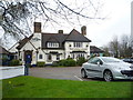
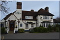
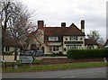
In the car park of the Robin Hood and Little John pub, lies a mysterious lonely megalith. The dark sarsen stone is about three feet across and has an unusual human-sized ‘footprint’ deeply embedded into it. It is about size 10, as my shoe size nearly fitted. Rather than a natural formation, the stone looks like it has been carved, a widespread tradition that local author Nigel Pennick says, could date back to the Neolithic era.
Another ancient looking stone sits embedded in the front driveway of a house next to Gladstone Way in Cherry Hinton, which is just behind the Robin Hood pub. Street names often give away clues to ancient traditions. The depth it goes into the ground is unknown, although to have a megalith, a kingship stone, circular henges, a possible round barrow and a natural spring all within a few hundred yards from one another deserves archaeological attention and another look at the folklore and prehistory of Cherry Hinton.
Read the full article at Hugh Newman's Ancient Wandlebury
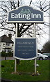
Web site for the Robin Hood and Little John Pub
You may be viewing yesterday's version of this page. To see the most up to date information please register for a free account.
Do not use the above information on other web sites or publications without permission of the contributor.
Nearby Images from Geograph Britain and Ireland:
©2016(licence)
©2016(licence)
©2016(licence)
©2007(licence)

©2021(licence)
The above images may not be of the site on this page, they are loaded from Geograph.
Please Submit an Image of this site or go out and take one for us!
Click here to see more info for this site
Nearby sites
Key: Red: member's photo, Blue: 3rd party photo, Yellow: other image, Green: no photo - please go there and take one, Grey: site destroyed
Download sites to:
KML (Google Earth)
GPX (GPS waypoints)
CSV (Garmin/Navman)
CSV (Excel)
To unlock full downloads you need to sign up as a Contributory Member. Otherwise downloads are limited to 50 sites.
Turn off the page maps and other distractions
Nearby sites listing. In the following links * = Image available
707m S 190° East Pit Nature Reserve* Ancient Village or Settlement (TL485555)
2.9km S 170° Gog and Magog Giants Hill Figures* Hill Figure or Geoglyph (TL492534)
2.9km SSE 168° Wandlebury* Hillfort (TL493534)
3.0km SW 231° Nine wells* Holy Well or Sacred Spring (TL46305420)
3.6km SSE 164° Wormwood Hill* Round Barrow(s) (TL497528)
3.9km SE 146° Copley Hill* Round Barrow(s) (TL509530)
4.0km WNW 297° Cambridge Fitzwilliam Museum* Museum (TL44955790)
4.1km WNW 300° Cambridge Museum of Archaeology & Anthropology* Museum (TL450581)
4.3km SSE 148° Babraham* Long Barrow (TL510526)
5.7km SW 217° Little Shelford Crosses* Ancient Cross (TL453516)
6.3km ESE 108° Mutlow Hill* Round Barrow(s) (TL5466354380)
8.3km NE 49° Bottisham Cursus Cursus (TL547619)
9.3km SSW 203° Chronicle Hills Barrow Cemetery (TL452475)
10.2km SSW 206° Thriplow Round Barrow(s) (TL4431646901)
10.9km W 270° The Mazles Turf Maze (TL377559)
11.5km SSW 201° Thriplow Ring Ditch Misc. Earthwork (TL44784537)
12.0km SSW 200° Thriplow Heath 1 Round Barrow(s) (TL4479044782)
12.6km NE 50° Devil's Dyke, Cambridgeshire* Misc. Earthwork (TL580646)
12.7km NW 321° St Michael's Well (Cambridge)* Holy Well or Sacred Spring (TL40326584)
13.0km SW 227° Shepreth Cursus (TL393471)
13.5km SSE 149° St. Botolph's Well (Hadstock)* Holy Well or Sacred Spring (TL55864478)
13.6km NE 45° The Burwells* Holy Well or Sacred Spring (TL5866)
13.6km SSW 203° Thrplow Heath 2 Round Barrow(s) (TL4362943549)
13.6km SW 228° Shepreth Cursus (TL387468)
14.4km S 183° Valance Farm Round Barrow(s) (TL4823241818)
View more nearby sites and additional images


 We would like to know more about this location. Please feel free to add a brief description and any relevant information in your own language.
 Wir möchten mehr über diese Stätte erfahren. Bitte zögern Sie nicht, eine kurze Beschreibung und relevante Informationen in Deutsch hinzuzufügen.
 Nous aimerions en savoir encore un peu sur les lieux. S'il vous plaît n'hesitez pas à ajouter une courte description et tous les renseignements pertinents dans votre propre langue.
 Quisieramos informarnos un poco más de las lugares. No dude en añadir una breve descripción y otros datos relevantes en su propio idioma.