<< Other Photo Pages >> Crowland Henge - Henge in England in Lincolnshire
Submitted by Andy B on Tuesday, 16 April 2024 Page Views: 419
Multi-periodSite Name: Crowland HengeCountry: England
NOTE: This site is 19.819 km away from the location you searched for.
County: Lincolnshire Type: Henge
Nearest Town: Peterborough Nearest Village: Crowland
Map Ref: TF25061086
Latitude: 52.681011N Longitude: 0.151514W
Condition:
| 5 | Perfect |
| 4 | Almost Perfect |
| 3 | Reasonable but with some damage |
| 2 | Ruined but still recognisable as an ancient site |
| 1 | Pretty much destroyed, possibly visible as crop marks |
| 0 | No data. |
| -1 | Completely destroyed |
| 5 | Superb |
| 4 | Good |
| 3 | Ordinary |
| 2 | Not Good |
| 1 | Awful |
| 0 | No data. |
| 5 | Can be driven to, probably with disabled access |
| 4 | Short walk on a footpath |
| 3 | Requiring a bit more of a walk |
| 2 | A long walk |
| 1 | In the middle of nowhere, a nightmare to find |
| 0 | No data. |
| 5 | co-ordinates taken by GPS or official recorded co-ordinates |
| 4 | co-ordinates scaled from a detailed map |
| 3 | co-ordinates scaled from a bad map |
| 2 | co-ordinates of the nearest village |
| 1 | co-ordinates of the nearest town |
| 0 | no data |
Internal Links:
External Links:

Because of its size and location, the henge (Late Neolithic or early Bronze Age - a type of circular earthwork) would have been a prominent place in the region and provided a major site for ceremonial activity. At this time, Crowland would have been a peninsula surrounded on three sides by water and marshes, and the henge was situated on a distinctive and highly visible point projecting out into the Fens.
The henge seems then to have been deserted, perhaps for many centuries, but the significance already given to the site by the substantial prehistoric earthworks – which would have still been visible into the medieval period - meant it was probably seen by hermits like Guthlac as a unique landscape with a long and sacred past.
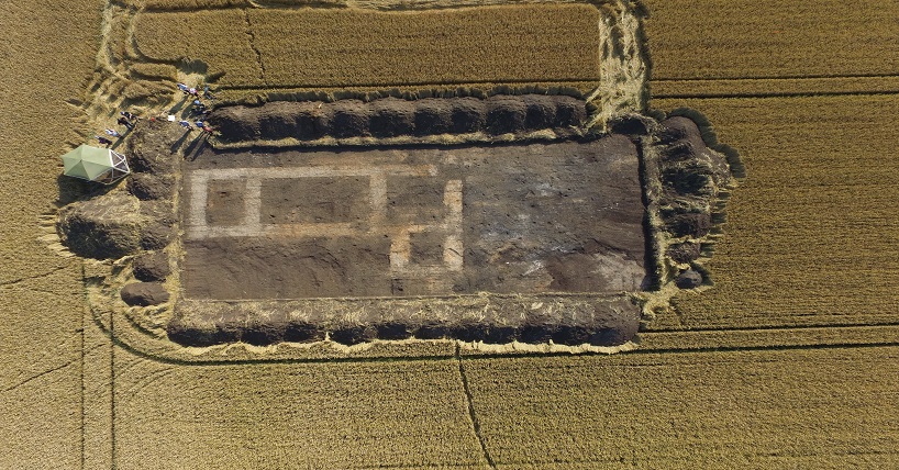
One of the evaluation trenches (Trench 1) was located over a feature visible on some aerial photography and satellite imagery. This extensive anomaly had been picked up by previous investigators but, presumably misjudging its scale, they had repeatedly labelled the feature as a ring ditch and interpreted it as a barrow. Closer examination reveals a circular anomaly of very different composition to a barrow, measuring approximately 75 m in diameter and surrounded by a ditch approximately 5 m wide. Excavation of Trench 1 confirmed the presence of a ditch running southeast to northwest through the middle of the trench.
Given the diameter of the feature and the proportions of its ditch, in addition to the presence of an external bank and the Middle Bronze Age post cut into its upper fill, it is clear that the feature is a henge constructed in the Neolithic or Early Bronze Age.
Although only a single post was identified in the narrow confines of the evaluation trench, its identification suggests that the henge remained a focus of ritual activity until at least the 14th century b.c. It is impossible to know whether the post stood in isolation or if it was part of a larger structure, but its positioning on the inner face of a still-visible ditch makes it tempting to see this as one element of a timber circle focused on the earlier monument. If this is the case, then the timber circle would have been incorporated into a more extensive Bronze Age ritual complex, with broadly contemporary barrows lining the peninsula, including one immediately west of the site, and terminating at the refurbished henge. The most easterly of this group may have been located within the henge itself, although an early Medieval origin for this feature cannot be discounted.
"We know that many prehistoric monuments were reused by the Anglo-Saxons, but to find a henge - especially one that was previously unknown - occupied in this way is really quite rare. By examining the archaeological evidence we uncovered and looking at historic texts, it’s clear that even in later years Anchor Church Field continued to be seen as a special place worthy of veneration," Dr Duncan Wright, Lecturer in Medieval Archaelogy, Newcastle University.
Source: Newcastle University Press Release
Sacred Landscapes and Deep Time: Mobility, Memory, and Monasticism on Crowland by Duncan W. Wright & Hugh Willmott, Journal of Field Archaeology 49, no. 4 (2024):
doi.org/10.1080/00934690.2024.2332853
With thanks to Lindsay Trevarthen for the link.
You may be viewing yesterday's version of this page. To see the most up to date information please register for a free account.

Do not use the above information on other web sites or publications without permission of the contributor.
Nearby Images from Geograph Britain and Ireland:

©2012(licence)

©2020(licence)

©2007(licence)

©2016(licence)

©2020(licence)
The above images may not be of the site on this page, they are loaded from Geograph.
Please Submit an Image of this site or go out and take one for us!
Click here to see more info for this site
Nearby sites
Key: Red: member's photo, Blue: 3rd party photo, Yellow: other image, Green: no photo - please go there and take one, Grey: site destroyed
Download sites to:
KML (Google Earth)
GPX (GPS waypoints)
CSV (Garmin/Navman)
CSV (Excel)
To unlock full downloads you need to sign up as a Contributory Member. Otherwise downloads are limited to 50 sites.
Turn off the page maps and other distractions
Nearby sites listing. In the following links * = Image available
7.0km WSW 240° Borough Fen* Hillfort (TF19080727)
7.2km S 172° Pode Hole Farm Round Barrow(s) (TF262037)
8.0km WNW 288° Deeping St Nicholas 28 Timber Circle (TF174132)
8.0km WNW 288° Deeping St Nicholas Round Barrow(s) (TF174132)
9.2km SSW 193° Oliver Cromwell's Hill (Eye) Cairn (TF232018)
9.8km WSW 258° Northborough Causewayed Enclosure Causewayed Enclosure (TF155085)
12.0km WSW 255° Etton Causewayed Enclosure* Causewayed Enclosure (TF135075)
12.2km SSW 193° Flag Fen Visitors Centre* Museum (TL227989)
12.2km WSW 255° Maxey Cursus Cursus (TF133074)
12.8km WSW 257° Maxey Henge Henge (TF12600772)
12.9km WSW 258° Maxey Pit Circle A Timber Circle (TF125078)
12.9km WSW 257° Maxey Pit Circle A Timber Circle (TF125077)
13.3km S 187° Must Farm* Ancient Village or Settlement (TL237976)
13.4km SSW 206° Hedda Stone* Early Christian Sculptured Stone (TL194987)
13.5km W 261° Maxey Cursus Cursus (TF11800830)
13.5km W 261° Maxey Cursus Cursus (TF118083)
13.8km SSW 208° Peterborough Stone* Standing Stone (Menhir) (TL190985)
13.8km SSW 208° Peterborough Museum* Museum (TL189985)
13.9km WSW 249° St Botolph (Helpston) Ancient Cross (TF12200552)
14.7km SSW 202° Fletton Cross* Ancient Cross (TL198971)
15.1km SW 214° St. Cloud's Well (Longthorpe)* Holy Well or Sacred Spring (TL16789815)
15.7km WSW 256° Bainton Cursus Cursus (TF099066)
16.5km W 270° Barholm Causewayed Enclosure Causewayed Enclosure (TF085105)
16.7km SW 223° Robin Hood and Little John* Standing Stones (TL1395098389)
17.2km WSW 258° Barnack Cursus Cursus (TF08360672)
View more nearby sites and additional images


 We would like to know more about this location. Please feel free to add a brief description and any relevant information in your own language.
 Wir möchten mehr über diese Stätte erfahren. Bitte zögern Sie nicht, eine kurze Beschreibung und relevante Informationen in Deutsch hinzuzufügen.
 Nous aimerions en savoir encore un peu sur les lieux. S'il vous plaît n'hesitez pas à ajouter une courte description et tous les renseignements pertinents dans votre propre langue.
 Quisieramos informarnos un poco más de las lugares. No dude en añadir una breve descripción y otros datos relevantes en su propio idioma.