


<< Our Photo Pages >> Acatitlan - Ancient Temple in Mexico in Estado de Mexico
Submitted by AlexHunger on Tuesday, 17 April 2007 Page Views: 7537
Multi-periodSite Name: Acatitlan Alternative Name: Santa Cecilia PyamidCountry: Mexico
NOTE: This site is 13.762 km away from the location you searched for.
Region: Estado de Mexico Type: Ancient Temple
Nearest Town: Mexico City Nearest Village: Tlalnepantla
Latitude: 19.552524N Longitude: 99.173276W
Condition:
| 5 | Perfect |
| 4 | Almost Perfect |
| 3 | Reasonable but with some damage |
| 2 | Ruined but still recognisable as an ancient site |
| 1 | Pretty much destroyed, possibly visible as crop marks |
| 0 | No data. |
| -1 | Completely destroyed |
| 5 | Superb |
| 4 | Good |
| 3 | Ordinary |
| 2 | Not Good |
| 1 | Awful |
| 0 | No data. |
| 5 | Can be driven to, probably with disabled access |
| 4 | Short walk on a footpath |
| 3 | Requiring a bit more of a walk |
| 2 | A long walk |
| 1 | In the middle of nowhere, a nightmare to find |
| 0 | No data. |
| 5 | co-ordinates taken by GPS or official recorded co-ordinates |
| 4 | co-ordinates scaled from a detailed map |
| 3 | co-ordinates scaled from a bad map |
| 2 | co-ordinates of the nearest village |
| 1 | co-ordinates of the nearest town |
| 0 | no data |
Internal Links:
External Links:
I have visited· I would like to visit
DrewParsons would like to visit
")
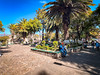
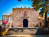
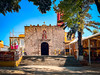
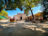
4 tiered temple platfom which may have had two small temples on top. There is a small museum near the church.
You may be viewing yesterday's version of this page. To see the most up to date information please register for a free account.
")
")
Do not use the above information on other web sites or publications without permission of the contributor.
Nearby Images from Flickr


The above images may not be of the site on this page, but were taken nearby. They are loaded from Flickr so please click on them for image credits.
Click here to see more info for this site
Nearby sites
Click here to view sites on an interactive map of the areaKey: Red: member's photo, Blue: 3rd party photo, Yellow: other image, Green: no photo - please go there and take one, Grey: site destroyed
Download sites to:
KML (Google Earth)
GPX (GPS waypoints)
CSV (Garmin/Navman)
CSV (Excel)
To unlock full downloads you need to sign up as a Contributory Member. Otherwise downloads are limited to 50 sites.
Turn off the page maps and other distractions
Nearby sites listing. In the following links * = Image available
2.3km SSE 167° Tenayuca* Pyramid / Mastaba
11.9km SSE 162° Tlatelolco* Ancient Village or Settlement
13.8km SSE 161° Tenochtitlan - Templo Mayor* Ancient Temple
14.1km S 186° Museo Nacional de Antropología* Museum
27.8km S 182° Cuicuilco* Pyramid / Mastaba
29.4km S 179° Tlalpan Ancient Village or Settlement
36.7km ENE 66° Teotihuacan - Tetitla Ancient Village or Settlement
36.9km ENE 65° Teotihuacan - Atelelco* Ancient Palace
37.1km ENE 67° Teotihuacan - Temple of Quetzalcoatl* Pyramid / Mastaba
37.6km ENE 65° Teotihuacan* Ancient Village or Settlement
37.7km E 99° Texcotzingo* Ancient Palace
37.9km ENE 66° Teotihuacan - Pyramid of the Sun* Pyramid / Mastaba
38.2km ENE 65° Teotihuacan - Pyramid of the Moon* Pyramid / Mastaba
59.7km NNW 343° Tula.* Ancient Village or Settlement
61.8km S 173° Tepoztlan* Ancient Village or Settlement
66.4km SW 222° Teotenango* Ancient Temple
69.4km S 184° Cuernavaca - Piramide de Teopanzolco* Pyramid / Mastaba
70.8km ENE 66° Tepeapulco Pyramid* Pyramid / Mastaba
78.9km SW 231° Nevado de Toluca Natural Stone / Erratic / Other Natural Feature
84.3km S 189° Xochicalco* Ancient Village or Settlement
86.6km WNW 303° Huamango Ancient Village or Settlement
92.9km ESE 111° Xochitecatl* Pyramid / Mastaba
93.5km ESE 111° Cacaxtla* Ancient Village or Settlement
105.5km NE 53° Huapalcalco Pyramid Pyramid / Mastaba
106.1km SSE 156° Chalcatzingo* Rock Art
View more nearby sites and additional images


 We would like to know more about this location. Please feel free to add a brief description and any relevant information in your own language.
 Wir möchten mehr über diese Stätte erfahren. Bitte zögern Sie nicht, eine kurze Beschreibung und relevante Informationen in Deutsch hinzuzufügen.
 Nous aimerions en savoir encore un peu sur les lieux. S'il vous plaît n'hesitez pas à ajouter une courte description et tous les renseignements pertinents dans votre propre langue.
 Quisieramos informarnos un poco más de las lugares. No dude en añadir una breve descripción y otros datos relevantes en su propio idioma.