


<< Text Pages >> Balcon de Montezuma - Ancient Village or Settlement in Mexico in Tamaulipas
Submitted by SolarMegalith on Thursday, 21 October 2010 Page Views: 4174
Multi-periodSite Name: Balcon de MontezumaCountry: Mexico
NOTE: This site is 16.539 km away from the location you searched for.
Region: Tamaulipas Type: Ancient Village or Settlement
Nearest Town: Ciudad Victoria
Latitude: 23.590130N Longitude: 99.1772W
Condition:
| 5 | Perfect |
| 4 | Almost Perfect |
| 3 | Reasonable but with some damage |
| 2 | Ruined but still recognisable as an ancient site |
| 1 | Pretty much destroyed, possibly visible as crop marks |
| 0 | No data. |
| -1 | Completely destroyed |
| 5 | Superb |
| 4 | Good |
| 3 | Ordinary |
| 2 | Not Good |
| 1 | Awful |
| 0 | No data. |
| 5 | Can be driven to, probably with disabled access |
| 4 | Short walk on a footpath |
| 3 | Requiring a bit more of a walk |
| 2 | A long walk |
| 1 | In the middle of nowhere, a nightmare to find |
| 0 | No data. |
| 5 | co-ordinates taken by GPS or official recorded co-ordinates |
| 4 | co-ordinates scaled from a detailed map |
| 3 | co-ordinates scaled from a bad map |
| 2 | co-ordinates of the nearest village |
| 1 | co-ordinates of the nearest town |
| 0 | no data |
Internal Links:
External Links:
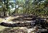
Balcon de Montezuma is located 26 km SW from Ciudad Victoria, near road 101 leading to San Luis Potosi. The site was occupied between 400 and 1200 BC, but it's heyday was in Late Classic period.
It consists of over 70 structures concentrated around two plazas, some of these buildings representing residential functions, the other religious ones. Most of the structures are poorly preserved, but excavations directed by Jesus Narez in years 1988-1990 brought lot of interesting finds including large amounts of Pre-Colombian pottery and smoking pipes.
You may be viewing yesterday's version of this page. To see the most up to date information please register for a free account.
Do not use the above information on other web sites or publications without permission of the contributor.
Nearby Images from Flickr

The above images may not be of the site on this page, but were taken nearby. They are loaded from Flickr so please click on them for image credits.
Click here to see more info for this site
Nearby sites
Click here to view sites on an interactive map of the areaKey: Red: member's photo, Blue: 3rd party photo, Yellow: other image, Green: no photo - please go there and take one, Grey: site destroyed
Download sites to:
KML (Google Earth)
GPX (GPS waypoints)
CSV (Garmin/Navman)
CSV (Excel)
To unlock full downloads you need to sign up as a Contributory Member. Otherwise downloads are limited to 50 sites.
Turn off the page maps and other distractions
Nearby sites listing. In the following links * = Image available
188.9km SSE 169° Tamtoc Ancient Village or Settlement
199.9km SE 138° Las Flores Pyramid / Mastaba
310.4km NNW 332° Boca de Potrerillos Rock Art
329.4km W 265° La Florida (Zacatecas) Shaft Tomb* Chambered Tomb
331.9km SSE 155° Cerro del Sombrerete Rock Art
348.9km SSE 147° Tubuco Ancient Mine, Quarry or other Industry
353.2km SSW 211° Cañada de la Virgen Ancient Village or Settlement
362.2km SSW 201° El Cerrito Pyramid / Mastaba
392.1km S 182° Tula.* Ancient Village or Settlement
393.7km WSW 252° La Quemada* Ancient Village or Settlement
395.2km SSE 168° Huapalcalco Pyramid Pyramid / Mastaba
395.6km SSE 152° El Tajin* Ancient Village or Settlement
407.8km S 190° Huamango Ancient Village or Settlement
424.8km S 171° Tepeapulco Pyramid* Pyramid / Mastaba
434.0km S 175° Teotihuacan - Pyramid of the Moon* Pyramid / Mastaba
434.8km S 175° Teotihuacan* Ancient Village or Settlement
434.8km S 175° Teotihuacan - Pyramid of the Sun* Pyramid / Mastaba
434.8km S 176° Teotihuacan - Atelelco* Ancient Palace
435.1km S 176° Teotihuacan - Tetitla Ancient Village or Settlement
435.9km S 175° Teotihuacan - Temple of Quetzalcoatl* Pyramid / Mastaba
449.0km S 180° Acatitlan* Ancient Temple
451.3km S 180° Tenayuca* Pyramid / Mastaba
455.4km SSW 209° Huandacareo Ancient Village or Settlement
456.6km S 175° Texcotzingo* Ancient Palace
460.3km S 179° Tlatelolco* Ancient Village or Settlement
View more nearby sites and additional images


 We would like to know more about this location. Please feel free to add a brief description and any relevant information in your own language.
 Wir möchten mehr über diese Stätte erfahren. Bitte zögern Sie nicht, eine kurze Beschreibung und relevante Informationen in Deutsch hinzuzufügen.
 Nous aimerions en savoir encore un peu sur les lieux. S'il vous plaît n'hesitez pas à ajouter une courte description et tous les renseignements pertinents dans votre propre langue.
 Quisieramos informarnos un poco más de las lugares. No dude en añadir una breve descripción y otros datos relevantes en su propio idioma.