


<< Our Photo Pages >> BoatHenge, Missouri - Modern Stone Circle etc in United States in The Plains
Submitted by bat400 on Sunday, 18 December 2016 Page Views: 12502
Modern SitesSite Name: BoatHenge, MissouriCountry: United States
NOTE: This site is 15.203 km away from the location you searched for.
Region: The Plains Type: Modern Stone Circle etc
Nearest Town: Columbia, MO Nearest Village: Easley, MO
Latitude: 38.818550N Longitude: 92.385816W
Condition:
| 5 | Perfect |
| 4 | Almost Perfect |
| 3 | Reasonable but with some damage |
| 2 | Ruined but still recognisable as an ancient site |
| 1 | Pretty much destroyed, possibly visible as crop marks |
| 0 | No data. |
| -1 | Completely destroyed |
| 5 | Superb |
| 4 | Good |
| 3 | Ordinary |
| 2 | Not Good |
| 1 | Awful |
| 0 | No data. |
| 5 | Can be driven to, probably with disabled access |
| 4 | Short walk on a footpath |
| 3 | Requiring a bit more of a walk |
| 2 | A long walk |
| 1 | In the middle of nowhere, a nightmare to find |
| 0 | No data. |
| 5 | co-ordinates taken by GPS or official recorded co-ordinates |
| 4 | co-ordinates scaled from a detailed map |
| 3 | co-ordinates scaled from a bad map |
| 2 | co-ordinates of the nearest village |
| 1 | co-ordinates of the nearest town |
| 0 | no data |
Internal Links:
External Links:
I have visited· I would like to visit
EddyHaskel visited on 1st Jan 2014 - their rating: Cond: 4 Amb: 4 Access: 4 Closest village is Easley, MO
Next closest is McBaine, MO
Rocheport, MO is about 10 miles north
")
BoatHenge can be found near the mouth of Little Bonne Femme Creek on Ploughboy's Bend. The location given is for the mouth of the creek and approximate for the site. To view the homage / yard art, go to the BoatHenge website.
You may be viewing yesterday's version of this page. To see the most up to date information please register for a free account.
")
")
Do not use the above information on other web sites or publications without permission of the contributor.
Nearby Images from Flickr
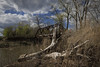
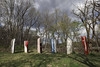
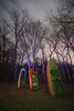
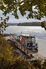
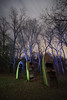
The above images may not be of the site on this page, but were taken nearby. They are loaded from Flickr so please click on them for image credits.
Click here to see more info for this site
Nearby sites
Click here to view sites on an interactive map of the areaKey: Red: member's photo, Blue: 3rd party photo, Yellow: other image, Green: no photo - please go there and take one, Grey: site destroyed
Download sites to:
KML (Google Earth)
GPX (GPS waypoints)
CSV (Garmin/Navman)
CSV (Excel)
To unlock full downloads you need to sign up as a Contributory Member. Otherwise downloads are limited to 50 sites.
Turn off the page maps and other distractions
Nearby sites listing. In the following links * = Image available
17.1km NW 321° Big Moniteau Rock Art
70.8km E 82° Graham Cave* Cave or Rock Shelter
90.2km WNW 303° Old Fort (Miami, MO)* Artificial Mound
109.6km SSE 151° UMR Stonehenge* Modern Stone Circle etc
147.9km NE 34° Indian Mounds Park* Artificial Mound
148.4km E 91° Schwendemann Farm Mound Artificial Mound
153.9km N 352° Thousand Hills Petroglyphs* Rock Art
159.8km E 95° Blake Mound Artificial Mound
160.4km E 83° Pere Marquette State Park* Artificial Mound
169.5km ESE 119° Washington State Park Petroglyphs* Rock Art
171.4km SW 226° Big Eddy* Ancient Mine, Quarry or other Industry
175.8km ENE 62° Montezuma Mound Group* Artificial Mound
178.9km NE 56° Elizabeth Mound Complex* Barrow Cemetery
180.7km ESE 105° Mastodon State Historic Site* Museum
189.0km E 98° Sugarloaf Mound, Missouri* Artificial Mound
189.5km E 87° Piasa Bird* Rock Art
191.8km E 95° Big Mound (St Louis)* Artificial Mound
194.8km E 95° East Saint Louis Mound Center* Ancient Village or Settlement
197.8km E 95° Sam Chucalo Mound* Artificial Mound
199.9km E 94° Fingerhut tract* Ancient Village or Settlement
199.9km E 94° Cahokia - Powell Mound Artificial Mound
201.2km E 94° Cahokia - Woodhenge* Timber Circle
201.3km E 93° Horseshoe Lake Mound* Artificial Mound
201.3km E 94° Cahokia - Mound 44* Artificial Mound
201.7km E 94° Cahokia - Mound 42* Artificial Mound
View more nearby sites and additional images


 We would like to know more about this location. Please feel free to add a brief description and any relevant information in your own language.
 Wir möchten mehr über diese Stätte erfahren. Bitte zögern Sie nicht, eine kurze Beschreibung und relevante Informationen in Deutsch hinzuzufügen.
 Nous aimerions en savoir encore un peu sur les lieux. S'il vous plaît n'hesitez pas à ajouter une courte description et tous les renseignements pertinents dans votre propre langue.
 Quisieramos informarnos un poco más de las lugares. No dude en añadir una breve descripción y otros datos relevantes en su propio idioma.