 with our Megalithic Portal iPhone app")


<< Text Pages >> Curraghmore - Stone Row / Alignment in Ireland (Republic of) in Co. Kerry
Submitted by Anonymous on Tuesday, 01 October 2002 Page Views: 5417
Neolithic and Bronze AgeSite Name: CurraghmoreCountry: Ireland (Republic of)
NOTE: This site is 3.397 km away from the location you searched for.
County: Co. Kerry Type: Stone Row / Alignment
Map Ref: V801819
Discovery Map Number: D78
Latitude: 51.976748N Longitude: 9.745654W
Condition:
| 5 | Perfect |
| 4 | Almost Perfect |
| 3 | Reasonable but with some damage |
| 2 | Ruined but still recognisable as an ancient site |
| 1 | Pretty much destroyed, possibly visible as crop marks |
| 0 | No data. |
| -1 | Completely destroyed |
| 5 | Superb |
| 4 | Good |
| 3 | Ordinary |
| 2 | Not Good |
| 1 | Awful |
| 0 | No data. |
| 5 | Can be driven to, probably with disabled access |
| 4 | Short walk on a footpath |
| 3 | Requiring a bit more of a walk |
| 2 | A long walk |
| 1 | In the middle of nowhere, a nightmare to find |
| 0 | No data. |
| 5 | co-ordinates taken by GPS or official recorded co-ordinates |
| 4 | co-ordinates scaled from a detailed map |
| 3 | co-ordinates scaled from a bad map |
| 2 | co-ordinates of the nearest village |
| 1 | co-ordinates of the nearest town |
| 0 | no data |
Internal Links:
External Links:
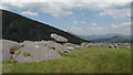
A Row of Three Stones (Alignment) in Co. Kerry
Have you visited this site? Please contribute a description or any thoughts by adding a comment.
You may be viewing yesterday's version of this page. To see the most up to date information please register for a free account.
Do not use the above information on other web sites or publications without permission of the contributor.
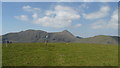
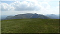
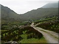
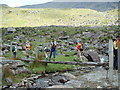
Nearby Images from Geograph Britain and Ireland:
©2018(licence)
©2018(licence)
©2005(licence)
©2006(licence)
©2018(licence)
The above images may not be of the site on this page, they are loaded from Geograph.
Please Submit an Image of this site or go out and take one for us!
Click here to see more info for this site
Nearby sites
Click here to view sites on an interactive map of the areaKey: Red: member's photo, Blue: 3rd party photo, Yellow: other image, Green: no photo - please go there and take one, Grey: site destroyed
Download sites to:
KML (Google Earth)
GPX (GPS waypoints)
CSV (Garmin/Navman)
CSV (Excel)
To unlock full downloads you need to sign up as a Contributory Member. Otherwise downloads are limited to 50 sites.
![]()
Turn off the page maps and other distractions
Nearby sites listing. In the following links * = Image available
1.8km ESE 115° Bunbinnia hut site and standing stone* Ancient Village or Settlement
4.1km WSW 253° Dromteewakeen Stone Row / Alignment (V761808)
5.5km SW 221° Derrynablaha* Rock Art (V764778)
5.6km SW 217° Derrynablaha Stone Row* Standing Stone (Menhir) (V7666077519)
6.7km SSW 193° Derrylicka* Stone Row / Alignment (V784754)
7.8km SSE 147° Boughill* Standing Stone (Menhir) (V8422075275)
8.8km SSW 195° Gearha* Standing Stones (V7756473414)
9.1km SSW 206° Gortacloghane Stone Row / Alignment (V759738)
9.7km SSE 150° Rossacoosane* Rock Art (V848734)
11.1km SSW 198° Dromlusk* Standing Stone (Menhir)
11.9km E 93° Gertroe Stone Circle (V920810)
12.0km NE 39° Coomagort ogham stones* Standing Stones
12.2km E 97° Esknamucky glen* Standing Stone (Menhir) (V922802)
12.7km SE 125° Carhoonmeengar East* Rock Art (V9040274338)
13.1km S 182° Derreenafoyle Standing Stones (V794688)
13.2km SSE 165° Lomanagh Holy Well* Holy Well or Sacred Spring
13.8km ESE 121° Inchimore* Cairn (V91827460)
15.1km NE 46° Fossa Stone * Standing Stone (Menhir) (V91169216)
15.4km SE 135° Kenmare* Stone Circle (V9067970713)
15.8km S 170° Tuosist* Stone Circle (V824663)
16.0km SE 129° Killowen* Stone Circle (V924716)
16.7km WNW 303° Kilnabreck Lower* Standing Stones (V66339144)
16.8km S 180° Ormonds Island* Standing Stones (V79716512)
17.2km W 280° Coomasaharn Lake Rock Art (V632852)
18.0km WNW 290° Coolnaharragill Rock Art (V633886)
View more nearby sites and additional images


 We would like to know more about this location. Please feel free to add a brief description and any relevant information in your own language.
 Wir möchten mehr über diese Stätte erfahren. Bitte zögern Sie nicht, eine kurze Beschreibung und relevante Informationen in Deutsch hinzuzufügen.
 Nous aimerions en savoir encore un peu sur les lieux. S'il vous plaît n'hesitez pas à ajouter une courte description et tous les renseignements pertinents dans votre propre langue.
 Quisieramos informarnos un poco más de las lugares. No dude en añadir una breve descripción y otros datos relevantes en su propio idioma.