

<< Our Photo Pages >> Lubaantun - Ancient Village or Settlement in Belize
Submitted by C_Michael_Hogan on Tuesday, 04 December 2007 Page Views: 19684
Multi-periodSite Name: Lubaantun Alternative Name: Place of the Fallen Stones, Rio GrandeCountry: Belize
NOTE: This site is 0.888 km away from the location you searched for.
Type: Ancient Village or Settlement
Nearest Town: Punta Gorda Nearest Village: San Miguel
Latitude: 16.282170N Longitude: 88.9596W
Condition:
| 5 | Perfect |
| 4 | Almost Perfect |
| 3 | Reasonable but with some damage |
| 2 | Ruined but still recognisable as an ancient site |
| 1 | Pretty much destroyed, possibly visible as crop marks |
| 0 | No data. |
| -1 | Completely destroyed |
| 5 | Superb |
| 4 | Good |
| 3 | Ordinary |
| 2 | Not Good |
| 1 | Awful |
| 0 | No data. |
| 5 | Can be driven to, probably with disabled access |
| 4 | Short walk on a footpath |
| 3 | Requiring a bit more of a walk |
| 2 | A long walk |
| 1 | In the middle of nowhere, a nightmare to find |
| 0 | No data. |
| 5 | co-ordinates taken by GPS or official recorded co-ordinates |
| 4 | co-ordinates scaled from a detailed map |
| 3 | co-ordinates scaled from a bad map |
| 2 | co-ordinates of the nearest village |
| 1 | co-ordinates of the nearest town |
| 0 | no data |
Internal Links:
External Links:
I have visited· I would like to visit
C_Michael_Hogan has visited here
")
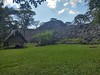
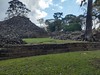
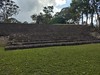
Construction features uncharacteristic of the Classic Mayan along with presence of megalithic elements have prompted some to associate this city with much earlier founding. Lubaantun is noted for its stunningly precise stonework, mysterious vacant stone tomb, multiple ball courts and doorless pyramids. This little visited site in the Toledo District is likely one of the oldest major stone built cities in the Americas. The work herein is based upon my on site research in December, 2006 and analysis of historic literature.
ARCHITECTURE Eleven major structures are found concentrated among five plazas; three ball courts are also dispersed on the site. The structures are noteworthy because they incorporate megaltihic elements into temple foundations and utilise purely drystone construction often finished with rounded corners. The only carvings found on site are three markers depicting the ancient Mesoamerican ball game; these artifacts are now at the Peabody Museum. (Lubaantun, 2007) Limestone and sandstone comprise most of the stone used. Thomas Gann opened a stone tomb with enormous capstones that was that was mysteriously vacant, unlike the typical Mayan customs. (Gann, 1905) Numerous other graves populate the site. Unlike almost all Mayan sites, the structures have no doors, leading to the supposition of a more primitive construction on the platforms and pyramids of wooden style buildings. Lubaantun is considered to be the largest prehistoric settlement in Southern Belize, (Southern, 2007) with a peak population of 20,000; the core city would have accommodated only a fraction of this number, with the bulk of the population living in simpler huts on surrounding farmlands.
ARTIFACTS. The most characteristic find of Lubaantun is the extensive collection of miniature ceramic objects. Most of these have characteristic dimensions of one to five centimetres and many are made in the form of whistles; the figurines are further notable for their early use of mould technology. These charmstone-like creations are often crafted with great artistry and make take the form of zoomorphic or human likenesses. In addition, grinding stone, turquoise, beads, shells and pottery shards. Further, obsidian blades as well as jade have been recovered, which minerals derive from the Guatemalan highlands. Bones of deep water marine species have been discovered, indicating the exploitation of the Caribbean Sea by the early inhabitants. In the mid 20th century the sensational find of a carved crystal skull stimulated controversy, until it was shown not to derive from Lubaantun, even though it may have had an ancient provenance.
ENVIRONMENT. The site is strategically positioned on a high ridge between two perennial streams, facilitating freshwater supply as well as navigation all the way to the Caribbean Sea. (Gann, 1926) The northern stream water quality is very good with turbidity Secchi disk readings of 72 centimetres. Lubaantun is situated in the foothills of the Maya Mountains, with the unpaved access road passable by vehicle only in the dry season. The site of elevation 197 feet above mean sea level is richly endowed with native broadleaf forest that now engulfs the city and has assisted in structure ruining through root development. From the southwestern-most terrace of Lubaantun, the visitor is rewarded by an expansive view of the swampy south Belize lowland and the Caribbean Sea beyond.
The temperatures of the foothills are not as hot and inhospitable as the coastal lowlands, so that the Lubaantun site and other foothill locations favoured settlement by early man in Belize. Abundant prehistoric wildlife, lush forests and surface rock formations for building made the locale ideal for prehistoric settlement. Farming, export of cacao beans and sea exploitation were the principal economic bases of the early inhabitants. The rapid ultimate evacuation of the city in the late ninth century AD, bears the hallmark of a people exceeding the carrying capacity of the region as a whole. It is likely that a population of 20,000 conducted such widespread deforestation, depletion of streams and exhaustion of arable soils in a region fundamentally unsuited for intensive farming, that the land could simply not support the civilisation at its peak.
DEBATE OVER FOUNDING. While it is undisputed that Lubaantun played a role in the Classic Mayan Period civilisation in the eighth and ninth centuries AD, it is less clear who founded the original city. There is broad agreement that the site architecture does not fit the conventional Mayan template; deviations from this norm include: (a) almost complete absence of stelae or other engravings; (b) absence of doorways in structures; (c) totally mortarless stonework; (d) megalithic elements in stonework; (e) anomalous find of a vacant unopened tomb (Gann, 1905); (f) apparent absence of residential structures in the core city; and (g) absence of any stone structures atop pyramids or platforms.
Gann, Mitchell-Hedges, Childress and others have suggested the earliest structures at Lubaantun may not have been constructed by Mayan people at all, but possibly a tribe more akin to South American cultures due to some similarities noted with Machu Picchu and other more southerly architecture. Radiocarbon dating that suggests Classic Period occupation primarily targets on cacao beans and other artifacts that merely could relate to the later occupation of the site. Phoenician influence is impossible to prove, even though those first millennium BC navigators were exceptional seafarers, but Childress advances the possiblity. From a logistical standpoint such early contact seems unlikely, although other researchers in addition to Childress have independently suggested early contact between Central Americans and Phoenicians. (Lee, 1978)(Danien, 1992) In my visit to Lubaantun and the Phoenician sites of Morocco (especially Mogador), (Hogan, 2007) I was also struck by similarities, mindful of the daunting logistics to enable such influence; other elements of stonework unusual to conventional Mayan forms are the tiered ."in and out" layering and the lateral joining of walls of different age. In conclusion, it seems most logical that Lubaantun was founded much earlier than the Classic Period, probably in the first millennium BC, while the founders may have been Mayan cultural predecessors or other tribes of a more southern derivation. In any case Lubaantun may be one of the oldest stone constructed cities in the Americas.
REFERENCES.
* ‘'Lubaantun: Place of the Fallen Stones'‘ (2007)
* southernbelize.com: Lubaantun (2007)
* Thomas Gann (1905) ‘' Mystery Cities of the Maya: Exploration and Adventure in Lubaantun and Belize'‘, republished 1997 by Adventures Unlimited Press ISBN 0932813178
* David Hatcher Childress (1992) ‘'Lost Cities of North & Central America'‘, Adventures Unlimited Press ISBN 0932813097
* Thomas A. Lee and Carlos Navarrete (1978) ‘'Mesoamerican Communication Routes and Cultural Contacts'‘, New World Archaeological Foundation, Brigham Young University, 265 pages
* Thomas William Francis Gann (1926) ‘'Ancient Cities and Modern Tribes: Exploration and Adventure in Maya Lands'‘, C. Scribner's sons, 256 pages
* Thomas A. Lee and Carlos Navarrete (1978) ‘'Mesoamerican Communication Routes and Cultural Contacts'‘, New World Archaeological Foundation, Brigham Young University, 265 pages
* Elin C. Danien and Robert J. Sharer (1992) ‘'New Theories on the Ancient Maya'‘, University of Pennsylvania Museum of Archaeology ISBN 0924171138
* C. Michael Hogan, ‘'Mogador'‘, the Megalithic Portal'‘, Nov. 2, 2007
(The above content was produced by C. Michael Hogan for the Megalithic Portal.)
You may be viewing yesterday's version of this page. To see the most up to date information please register for a free account.
")
")
")
")
Do not use the above information on other web sites or publications without permission of the contributor.
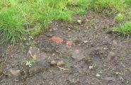
Nearby Images from Flickr


The above images may not be of the site on this page, but were taken nearby. They are loaded from Flickr so please click on them for image credits.
Click here to see more info for this site
Nearby sites
Click here to view sites on an interactive map of the areaKey: Red: member's photo, Blue: 3rd party photo, Yellow: other image, Green: no photo - please go there and take one, Grey: site destroyed
Download sites to:
KML (Google Earth)
GPX (GPS waypoints)
CSV (Garmin/Navman)
CSV (Excel)
To unlock full downloads you need to sign up as a Contributory Member. Otherwise downloads are limited to 50 sites.
Turn off the page maps and other distractions
Nearby sites listing. In the following links * = Image available
15.1km ENE 73° Nim Li Punit* Ancient Village or Settlement
32.5km NNE 28° Quebrada de Oro Ancient Village or Settlement
38.4km E 92° Ka'k' Naab' saltworks Ancient Mine, Quarry or other Industry
56.2km NNW 343° Caracol Ancient Village or Settlement
87.2km NW 313° Chilonche Ancient Village or Settlement
91.5km NNW 327° Holtun* Ancient Village or Settlement
91.9km NNW 348° Xunantunich* Ancient Village or Settlement
92.9km N 352° Chaa Creek* Ancient Village or Settlement
96.8km N 353° Cahal Pech Ancient Village or Settlement
99.4km NNW 332° Yaxha* Ancient Village or Settlement
100.0km NNW 341° Naranjo* Ancient Village or Settlement
109.0km NW 315° Ixlú Ancient Village or Settlement
110.0km N 350° El Pilar* Ancient Village or Settlement
110.1km NNW 335° Nakum* Ancient Village or Settlement
112.7km S 184° Quirigua* Ancient Village or Settlement
116.9km N 10° Saturday Creek Ancient Village or Settlement
119.3km WSW 256° Cancuen* Ancient Village or Settlement
119.3km NNW 344° Holmul Ancient Village or Settlement
120.2km WNW 282° Ceibal* Ancient Village or Settlement
122.7km NW 306° Nojpetén* Ancient Village or Settlement
123.9km NNW 346° Cival Ancient Village or Settlement
126.6km N 4° Cara Blanca Natural Stone / Erratic / Other Natural Feature
126.7km NW 326° Tikal* Ancient Village or Settlement
127.5km NW 306° Nixtun-Ch'ich' Ancient Village or Settlement
131.6km S 172° El Puente Ancient Village or Settlement
View more nearby sites and additional images


 We would like to know more about this location. Please feel free to add a brief description and any relevant information in your own language.
 Wir möchten mehr über diese Stätte erfahren. Bitte zögern Sie nicht, eine kurze Beschreibung und relevante Informationen in Deutsch hinzuzufügen.
 Nous aimerions en savoir encore un peu sur les lieux. S'il vous plaît n'hesitez pas à ajouter une courte description et tous les renseignements pertinents dans votre propre langue.
 Quisieramos informarnos un poco más de las lugares. No dude en añadir una breve descripción y otros datos relevantes en su propio idioma.