 with our Megalithic Portal iPhone app")

<< Other Photo Pages >> Roxbury Indian Mound - Artificial Mound in United States in The South
Submitted by Andy B on Friday, 28 July 2023 Page Views: 326
Pre-ColumbianSite Name: Roxbury Indian Mound Alternative Name: Chickamauga MoundCountry: United States Region: The South Type: Artificial Mound
Nearest Town: Chattanooga
Latitude: 35.089100N Longitude: 85.26185W
Condition:
| 5 | Perfect |
| 4 | Almost Perfect |
| 3 | Reasonable but with some damage |
| 2 | Ruined but still recognisable as an ancient site |
| 1 | Pretty much destroyed, possibly visible as crop marks |
| 0 | No data. |
| -1 | Completely destroyed |
| 5 | Superb |
| 4 | Good |
| 3 | Ordinary |
| 2 | Not Good |
| 1 | Awful |
| 0 | No data. |
| 5 | Can be driven to, probably with disabled access |
| 4 | Short walk on a footpath |
| 3 | Requiring a bit more of a walk |
| 2 | A long walk |
| 1 | In the middle of nowhere, a nightmare to find |
| 0 | No data. |
| 5 | co-ordinates taken by GPS or official recorded co-ordinates |
| 4 | co-ordinates scaled from a detailed map |
| 3 | co-ordinates scaled from a bad map |
| 2 | co-ordinates of the nearest village |
| 1 | co-ordinates of the nearest town |
| 0 | no data |
Internal Links:
External Links:
")
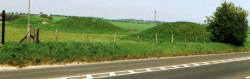
Named after the carpet mill once located next to it, Roxbury Mound is the best-preserved example of prehistoric earthworks remaining in Chattanooga. A small Cherokee settlement from the 18th century is also documented for this general location.
Sadly, the mound was extensively looted during the early 20th century, and the village area was damaged by construction activities. Only small, scattered remnants of a once-thriving Native American community are found today.
Source: https://www.hmdb.org/m.asp?m=167959
See also: http://www.moccasinbend.net/cita/chickamaugamound/index.html
You may be viewing yesterday's version of this page. To see the most up to date information please register for a free account.
Do not use the above information on other web sites or publications without permission of the contributor.
Nearby Images from Flickr

The above images may not be of the site on this page, but were taken nearby. They are loaded from Flickr so please click on them for image credits.
Click here to see more info for this site
Nearby sites
Click here to view sites on an interactive map of the areaKey: Red: member's photo, Blue: 3rd party photo, Yellow: other image, Green: no photo - please go there and take one, Grey: site destroyed
Download sites to:
KML (Google Earth)
GPX (GPS waypoints)
CSV (Garmin/Navman)
CSV (Excel)
To unlock full downloads you need to sign up as a Contributory Member. Otherwise downloads are limited to 50 sites.
Turn off the page maps and other distractions
Nearby sites listing. In the following links * = Image available
36.6km ENE 67° Candies Creek Village Archaeological Preserve* Ancient Village or Settlement
44.6km NNE 34° Hiwassee Island Mounds* Artificial Mound
51.5km WSW 256° Russell Cave* Cave or Rock Shelter
51.5km WSW 256° Russell Cave Mound* Artificial Mound
62.9km SE 125° Fort Mountain Stone Enclosure* Cairn
88.3km WNW 300° Old Stone Fort* Hillfort
98.3km SSW 198° Coker Ford Site* Ancient Village or Settlement
106.8km SSW 211° Collinsville Indian Mound* Artificial Mound
107.2km SE 143° Funk Heritage Center* Museum
112.5km SSE 159° Arborrigg* Modern Stone Circle etc
114.7km SSE 159° Etowah Mounds Museum* Museum
114.7km SSE 159° Etowah Mounds - Ditch and Palisade* Misc. Earthwork
115.0km SSE 159° Etowah Mounds - Mound A* Artificial Mound
115.1km SSE 159° Etowah Mounds - Mound C* Artificial Mound
115.1km SSE 159° Etowah Mounds - Mound B* Artificial Mound
117.3km N 360° Monterey Standing Stone* Standing Stone (Menhir)
128.2km E 100° Track Rock* Rock Art
128.9km E 100° Track Rock Gap Archaeological Area* Stone Row / Alignment
135.0km ENE 78° Sculptured Stone near Robbinsville* Sculptured Stone
137.2km NW 313° Black Cat Cave Cave or Rock Shelter
142.6km ESE 107° Hickorynut Track Rock* Rock Art
148.7km ESE 107° Nacoochee* Barrow Cemetery
148.9km SSW 196° Shelton Stone Mound Complex* Cairn
149.2km NW 324° Sellars Farm* Ancient Village or Settlement
151.1km ESE 107° Kenimer* Artificial Mound
View more nearby sites and additional images


 We would like to know more about this location. Please feel free to add a brief description and any relevant information in your own language.
 Wir möchten mehr über diese Stätte erfahren. Bitte zögern Sie nicht, eine kurze Beschreibung und relevante Informationen in Deutsch hinzuzufügen.
 Nous aimerions en savoir encore un peu sur les lieux. S'il vous plaît n'hesitez pas à ajouter une courte description et tous les renseignements pertinents dans votre propre langue.
 Quisieramos informarnos un poco más de las lugares. No dude en añadir una breve descripción y otros datos relevantes en su propio idioma.