

<< Our Photo Pages >> University of Tennessee Agriculture Farm Mound - Barrow Cemetery in United States in The South
Submitted by bat400 on Wednesday, 16 August 2017 Page Views: 1853
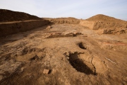
Neolithic and Bronze AgeSite Name: University of Tennessee Agriculture Farm Mound Alternative Name: U. T. Agriculture Farm MoundCountry: United States
NOTE: This site is 34.201 km away from the location you searched for.
Region: The South Type: Barrow Cemetery
Nearest Town: Knoxville, TN
Latitude: 35.947000N Longitude: 83.94W
Condition:
| 5 | Perfect |
| 4 | Almost Perfect |
| 3 | Reasonable but with some damage |
| 2 | Ruined but still recognisable as an ancient site |
| 1 | Pretty much destroyed, possibly visible as crop marks |
| 0 | No data. |
| -1 | Completely destroyed |
| 5 | Superb |
| 4 | Good |
| 3 | Ordinary |
| 2 | Not Good |
| 1 | Awful |
| 0 | No data. |
| 5 | Can be driven to, probably with disabled access |
| 4 | Short walk on a footpath |
| 3 | Requiring a bit more of a walk |
| 2 | A long walk |
| 1 | In the middle of nowhere, a nightmare to find |
| 0 | No data. |
| 5 | co-ordinates taken by GPS or official recorded co-ordinates |
| 4 | co-ordinates scaled from a detailed map |
| 3 | co-ordinates scaled from a bad map |
| 2 | co-ordinates of the nearest village |
| 1 | co-ordinates of the nearest town |
| 0 | no data |
Internal Links:
External Links:
")
A National Historic Places Register site.
Title: U. T. Agriculture Farm Mound
National Register Information System ID: 78002603
Applicable Criteria: INFORMATION POTENTIAL
Areas Of Significance: PREHISTORIC
Periods Of Significance: 1000-500 AD
Resource Type: SITE
Date Published: 3/30/1978
You may be viewing yesterday's version of this page. To see the most up to date information please register for a free account.
")
Do not use the above information on other web sites or publications without permission of the contributor.
Nearby Images from Flickr


The above images may not be of the site on this page, but were taken nearby. They are loaded from Flickr so please click on them for image credits.
Click here to see more info for this site
Nearby sites
Click here to view sites on an interactive map of the areaKey: Red: member's photo, Blue: 3rd party photo, Yellow: other image, Green: no photo - please go there and take one, Grey: site destroyed
Download sites to:
KML (Google Earth)
GPX (GPS waypoints)
CSV (Garmin/Navman)
CSV (Excel)
To unlock full downloads you need to sign up as a Contributory Member. Otherwise downloads are limited to 50 sites.
Turn off the page maps and other distractions
Nearby sites listing. In the following links * = Image available
1.3km ENE 65° McClung Museum of Natural History and Culture* Museum
70.0km S 170° Sculptured Stone near Robbinsville* Sculptured Stone
74.6km SE 139° Kituwah* Ancient Village or Settlement
76.2km SE 132° Museum of the Cherokee Indian* Museum
89.3km SSE 148° Cowee Mound Artificial Mound
92.2km NNE 31° Ely Mound* Artificial Mound
99.0km SSE 149° Nikwasi Mound* Artificial Mound
100.3km E 93° Hot Springs (North Carolina)* Holy Well or Sacred Spring
103.6km SE 134° Judaculla Rock* Rock Art
111.2km WSW 239° Hiwassee Island Mounds* Artificial Mound
118.1km SW 227° Candies Creek Village Archaeological Preserve* Ancient Village or Settlement
118.2km S 177° Track Rock* Rock Art
118.8km S 177° Track Rock Gap Archaeological Area* Stone Row / Alignment
121.1km W 281° Monterey Standing Stone* Standing Stone (Menhir)
133.1km ESE 109° Biltmore Mound Artificial Mound
135.2km N 7° Red Bird Petroglyphs Rock Art
138.3km S 173° Hickorynut Track Rock* Rock Art
142.1km S 171° Nacoochee* Barrow Cemetery
142.2km S 170° Sautee-Nacoochee earthwork Ancient Village or Settlement
142.5km S 170° Kenimer* Artificial Mound
148.8km SSW 208° Fort Mountain Stone Enclosure* Cairn
153.0km SW 232° Roxbury Indian Mound* Artificial Mound
158.3km SE 135° South Carolina Rock Art Center* Rock Art
161.1km ESE 109° Chimney Rock (North Carolina)* Natural Stone / Erratic / Other Natural Feature
182.2km N 352° Indian Fort Mountain* Hillfort
View more nearby sites and additional images


 We would like to know more about this location. Please feel free to add a brief description and any relevant information in your own language.
 Wir möchten mehr über diese Stätte erfahren. Bitte zögern Sie nicht, eine kurze Beschreibung und relevante Informationen in Deutsch hinzuzufügen.
 Nous aimerions en savoir encore un peu sur les lieux. S'il vous plaît n'hesitez pas à ajouter une courte description et tous les renseignements pertinents dans votre propre langue.
 Quisieramos informarnos un poco más de las lugares. No dude en añadir una breve descripción y otros datos relevantes en su propio idioma.