<< Text Pages >> Big (Tony's) Circle Mounds - Artificial Mound in United States in The South
Submitted by AKFisher on Tuesday, 01 August 2023 Page Views: 415
Multi-periodSite Name: Big (Tony's) Circle Mounds Alternative Name: Tony's Mound, Big Mound CircleCountry: United States Region: The South Type: Artificial Mound
Nearest Town: Clewiston, FL
Latitude: 26.550221N Longitude: 80.940249W
Condition:
| 5 | Perfect |
| 4 | Almost Perfect |
| 3 | Reasonable but with some damage |
| 2 | Ruined but still recognisable as an ancient site |
| 1 | Pretty much destroyed, possibly visible as crop marks |
| 0 | No data. |
| -1 | Completely destroyed |
| 5 | Superb |
| 4 | Good |
| 3 | Ordinary |
| 2 | Not Good |
| 1 | Awful |
| 0 | No data. |
| 5 | Can be driven to, probably with disabled access |
| 4 | Short walk on a footpath |
| 3 | Requiring a bit more of a walk |
| 2 | A long walk |
| 1 | In the middle of nowhere, a nightmare to find |
| 0 | No data. |
| 5 | co-ordinates taken by GPS or official recorded co-ordinates |
| 4 | co-ordinates scaled from a detailed map |
| 3 | co-ordinates scaled from a bad map |
| 2 | co-ordinates of the nearest village |
| 1 | co-ordinates of the nearest town |
| 0 | no data |
Internal Links:
External Links:
Artificial Mound in The South
From Wikipedia:
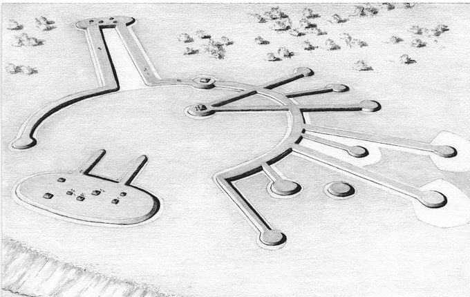
"Tony's Mound (Also Big Mound Circle) (8HN3) is a prehistoric to historic period archaeological site located on Dixie Dyke Road, south of Clewiston in Hendry County, Florida. Tony's Mound is one of two monumental earthwork complexes built in southern Florida by the Glade cultures around 1000 BCE using unique and distinct sand ridges, causeways and mounds. The other site is Big Mound City, twenty-five miles to the northeast in Palm Beach County. The ritual complex was first described in print by Ross Allen in the 1948.[1] Aerial photography showed a site consisting of nine raised causeways radiating from an immense plaza and central flat mound/midden on privately owned land used for cattle ranching.[1]
History:
In 1946, Ross Allen planned a ten-day expedition with George Espenlaub, Ned Moren, George J. Leahy, Bob Morrow, and George Marnhout. Before setting out, George Marnhout flew over the site while Lawrence Bright filmed and photographed from the plane. The group traveled all day on swamp buggies until they set up camp under a hammock, ten minutes from the mounds.[1]
During their visit, they found the grassy site to be very dry, about three miles northeast of cypress swamps. Allen reports that the area was "so extensive, that it cannot be seen in its entirety from the ground, but as we measured and walked over the area, we became more fascinated by this strange group."[1] He also reported that the mound was 580 feet diameter with circumference of 1665 feet. He said that a "roadway-like embankment" was about 10 to 15 feet wide. Allen further described "raised pathways," six feet in width, connecting the main circle to 19 to 22 smaller circles surrounding it. Beyond the mounds, Allen notes that there was a stand-alone "crescent-like raised earthwork."[1]
On Tony's Mound, the main mound measuring 110 feet by 83 feet, they found sugarberries, banyan, mulberries, papaya, saw palmetto and other small plants. Extending from the north side of the mound, there was a "canal-like depression 600 feet long, flanked by spoil banks or raised pathways 30 feet in width."[1] The largest mound was measured to be "390 feet in length and 135 feet wide; there is a small canal leading to it."[1]
There was a potential burial mound about a quarter of a mile to the northwest, covered by trees and vegetation. Allen suspected that the area was surrounded by deep water, which "doubtless provided both fishing and water transportation" with "good hunting and palm materials for construction."[1] He also notes that "wild turkey and deer abound" around the mounds.[1] According to Allen, "there had been deep water next to the homes of the Indians, and that the canals certainly provided a waterway to the most important mounds," with the mounds being the only potential dry land.[1]
From 1980 to the present, leading archaeologists, including Jerald T. Milanich, have referenced the site and its importance. Milanich used Tony's Mound as an example of engineering by the "Belle Glade culture".[2][3] In 2014, after excavating the related Fort Center site in Glades County, Thompson and Pluckhahn concluded that Tony's Mound, Big Mound City and Fort Center represented the most important "earthworks built by hunter-gathers in world prehistory".[4]"
References:
1. Allen, Ross (May 1948). "The Big Circle Mounds". The Florida Anthropologist. I: 17–21 – via University of Florida George A. Smathers Library Digital Collection.
2. Milanich, Jerald T. (1994). Archaeology of Precolumbian Florida. Gainesville, Florida: The University of Florida Press. pp. 281–282. ISBN 0-8130-1273-2.
3. Milanich, Jerald T. (1998). Florida's Indians From Ancient Times to the Present. Gainesville, Florida: University Press of Florida. pp. 112–122. ISBN 9780813015989.
4. Thompson, Victor D.; Pluckhahn, Thomas J. (2014). "The Modification and Manipulation of Landscape at Fort Center". In Wallis, Neill J.; Randall, Asa R. (eds.). New Histories of Pre-Columbian Florida. Gainesville, Florida: University Press of Florida. pp. 163–182. ISBN 9780813049366.
Further reading and information:
Wiki: https://en.wikipedia.org/wiki/Tony%27s_Mound#:~:text=Tony's%20Mound%20(Also%20Big%20Mound,Clewiston%20in%20Hendry%20County%2C%20Florida.
Mountain Zone:
https://www.mountainzone.com/mountains/florida/hendry-fl/summits/tonys-mound/
Directions: From Clewiston, via Evercane Rd. south, 18.3 mi.
You may be viewing yesterday's version of this page. To see the most up to date information please register for a free account.

Do not use the above information on other web sites or publications without permission of the contributor.
Nearby Images from Flickr


The above images may not be of the site on this page, but were taken nearby. They are loaded from Flickr so please click on them for image credits.
Click here to see more info for this site
Nearby sites
Click here to view sites on an interactive map of the areaKey: Red: member's photo, Blue: 3rd party photo, Yellow: other image, Green: no photo - please go there and take one, Grey: site destroyed
Download sites to:
KML (Google Earth)
GPX (GPS waypoints)
CSV (Garmin/Navman)
CSV (Excel)
To unlock full downloads you need to sign up as a Contributory Member. Otherwise downloads are limited to 50 sites.
Turn off the page maps and other distractions
Nearby sites listing. In the following links * = Image available
46.7km NNE 19° Lake Okeechobee* Ancient Village or Settlement
47.1km NW 310° Ortona Prehistoric Village Artificial Mound
50.1km NNW 334° Fort Center Archaeological Site* Artificial Mound
58.4km NE 52° Big Mound City Misc. Earthwork
93.1km W 261° Mound Key Archaeological State Park Artificial Mound
96.3km ENE 63° Jupiter Inlet Mound* Artificial Mound
97.9km WSW 242° Naples Canal Not Known (by us)
105.5km SE 133° Arch Creek Middens, Florida* Ancient Village or Settlement
107.8km SE 136° El Portal Burial Mound* Artificial Mound
114.7km SE 139° Miami Circle Rock Art
120.9km W 276° Pineland* Ancient Village or Settlement
126.8km SSE 157° Coral Castle* Modern Stone Circle etc
132.6km NNE 24° Vero Beach* Ancient Village or Settlement
140.9km WNW 295° Little Salt Spring Natural Stone / Erratic / Other Natural Feature
160.0km N 7° Three Forks Marsh Artificial Mound
166.6km SSE 161° Key Largo Rock Mound Ancient Temple
170.1km NW 310° Portavant Mound Site Artificial Mound
170.9km WNW 296° Spanish Point Shell Midden* Artificial Mound
180.6km WNW 299° Humming Stone Sarasota (Summstein)* Modern Stone Circle etc
187.3km ESE 117° Bimini Road Natural Stone / Erratic / Other Natural Feature
198.9km NW 305° Madira Bickel Mound State Archaeological Site* Artificial Mound
200.4km WNW 303° De Soto National Memorial* Artificial Mound
201.0km WNW 303° Pillsbury Temple Mound Artificial Mound
205.2km N 5° Brevard Museum of History and Natural Sciences* Museum
219.1km NW 312° Weedon Island Preserve* Barrow Cemetery
View more nearby sites and additional images


 We would like to know more about this location. Please feel free to add a brief description and any relevant information in your own language.
 Wir möchten mehr über diese Stätte erfahren. Bitte zögern Sie nicht, eine kurze Beschreibung und relevante Informationen in Deutsch hinzuzufügen.
 Nous aimerions en savoir encore un peu sur les lieux. S'il vous plaît n'hesitez pas à ajouter une courte description et tous les renseignements pertinents dans votre propre langue.
 Quisieramos informarnos un poco más de las lugares. No dude en añadir una breve descripción y otros datos relevantes en su propio idioma.