

<< Other Photo Pages >> Kuntur Wasi - Ancient Temple in Peru
Submitted by davidmorgan on Friday, 15 January 2016 Page Views: 1225
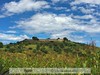
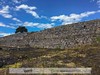
Multi-periodSite Name: Kuntur WasiCountry: Peru
NOTE: This site is 26.819 km away from the location you searched for.
Type: Ancient Temple
Nearest Town: San Pablo
Latitude: 7.128789S Longitude: 78.846126W
Condition:
| 5 | Perfect |
| 4 | Almost Perfect |
| 3 | Reasonable but with some damage |
| 2 | Ruined but still recognisable as an ancient site |
| 1 | Pretty much destroyed, possibly visible as crop marks |
| 0 | No data. |
| -1 | Completely destroyed |
| 5 | Superb |
| 4 | Good |
| 3 | Ordinary |
| 2 | Not Good |
| 1 | Awful |
| 0 | No data. |
| 5 | Can be driven to, probably with disabled access |
| 4 | Short walk on a footpath |
| 3 | Requiring a bit more of a walk |
| 2 | A long walk |
| 1 | In the middle of nowhere, a nightmare to find |
| 0 | No data. |
| 5 | co-ordinates taken by GPS or official recorded co-ordinates |
| 4 | co-ordinates scaled from a detailed map |
| 3 | co-ordinates scaled from a bad map |
| 2 | co-ordinates of the nearest village |
| 1 | co-ordinates of the nearest town |
| 0 | no data |
Internal Links:
External Links:
")
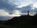
A temple and sunken courtyard dating from around 1000-700 BCE.
You may be viewing yesterday's version of this page. To see the most up to date information please register for a free account.
Do not use the above information on other web sites or publications without permission of the contributor.
Nearby Images from Flickr

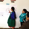
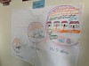
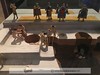
The above images may not be of the site on this page, but were taken nearby. They are loaded from Flickr so please click on them for image credits.
Click here to see more info for this site
Nearby sites
Click here to view sites on an interactive map of the areaKey: Red: member's photo, Blue: 3rd party photo, Yellow: other image, Green: no photo - please go there and take one, Grey: site destroyed
Download sites to:
KML (Google Earth)
GPX (GPS waypoints)
CSV (Garmin/Navman)
CSV (Excel)
To unlock full downloads you need to sign up as a Contributory Member. Otherwise downloads are limited to 50 sites.
Turn off the page maps and other distractions
Nearby sites listing. In the following links * = Image available
30.3km ESE 103° Cumbemayo Rock Art
42.8km E 90° Ventanillas de Otuzco Rock Cut Tomb
47.6km WNW 293° Nanchoc Ancient Village or Settlement
82.5km SSW 208° Mocollope Ancient Village or Settlement
88.1km W 280° Huaca el Pueblo Pyramid / Mastaba
90.3km NNW 348° Pacopampa Ancient Temple
91.1km WNW 294° Huaca Rajada Pyramid / Mastaba
99.2km WNW 297° Cerro Pátapo Ancient Village or Settlement
99.3km SSW 197° Cerro Campana* Sculptured Stone
101.1km SSW 210° El Brujo* Ancient Village or Settlement
104.8km S 184° Caballo Muerto Ancient Village or Settlement
107.0km WNW 290° Ventarron - Temple of the Captured Deer Ancient Temple
109.2km WNW 291° Collud Ancient Temple
110.7km SSW 191° Huaca Esmeralda* Pyramid / Mastaba
111.8km SSW 193° Chan Chan* Ancient Village or Settlement
111.9km SSW 195° Huanchaquito-Las Llamas Misc. Earthwork
112.0km SE 131° Marcahuamachuco* Ancient Village or Settlement
112.7km S 188° Huaca del Sol* Pyramid / Mastaba
113.0km S 188° Huaca de la Luna* Ancient Temple
113.8km S 188° Museo Huacas de Moche Museum
117.2km NE 40° Gran Vilaya / Rabantu* Ancient Village or Settlement
124.7km NW 316° Cerro Cerrillos Natural Stone / Erratic / Other Natural Feature
125.4km WNW 292° Museo Tumbas Reales de Sipán* Museum
127.6km NW 305° Pomac Forest Ancient Village or Settlement
128.2km NW 322° El Gallo Tombs Burial Chamber or Dolmen
View more nearby sites and additional images


 We would like to know more about this location. Please feel free to add a brief description and any relevant information in your own language.
 Wir möchten mehr über diese Stätte erfahren. Bitte zögern Sie nicht, eine kurze Beschreibung und relevante Informationen in Deutsch hinzuzufügen.
 Nous aimerions en savoir encore un peu sur les lieux. S'il vous plaît n'hesitez pas à ajouter une courte description et tous les renseignements pertinents dans votre propre langue.
 Quisieramos informarnos un poco más de las lugares. No dude en añadir una breve descripción y otros datos relevantes en su propio idioma.