


<< Our Photo Pages >> Puma Temple - Ancient Temple in Peru
Submitted by Michelledubois on Saturday, 08 October 2011 Page Views: 5074
Multi-periodSite Name: Puma Temple Alternative Name: Pumaqaqa, Pumapunku, Puma Pumku, Puma PuncuCountry: Peru Type: Ancient Temple
Nearest Town: Cuzco Nearest Village: Chinchero
Latitude: 13.389077S Longitude: 72.044618W
Condition:
| 5 | Perfect |
| 4 | Almost Perfect |
| 3 | Reasonable but with some damage |
| 2 | Ruined but still recognisable as an ancient site |
| 1 | Pretty much destroyed, possibly visible as crop marks |
| 0 | No data. |
| -1 | Completely destroyed |
| 5 | Superb |
| 4 | Good |
| 3 | Ordinary |
| 2 | Not Good |
| 1 | Awful |
| 0 | No data. |
| 5 | Can be driven to, probably with disabled access |
| 4 | Short walk on a footpath |
| 3 | Requiring a bit more of a walk |
| 2 | A long walk |
| 1 | In the middle of nowhere, a nightmare to find |
| 0 | No data. |
| 5 | co-ordinates taken by GPS or official recorded co-ordinates |
| 4 | co-ordinates scaled from a detailed map |
| 3 | co-ordinates scaled from a bad map |
| 2 | co-ordinates of the nearest village |
| 1 | co-ordinates of the nearest town |
| 0 | no data |
Internal Links:
External Links:
I have visited· I would like to visit
Michelledubois has visited here
")
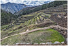
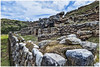
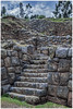
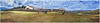
This temple site is clearly much older than the Inca. It is located on the western perimeter of the plaza in Chinchero. This is a beautiful and very spiritual place. I hope the puma can be made out. It's not hard to make it out in person, but these photos leave a bit to be desired. Sorry.
You may be viewing yesterday's version of this page. To see the most up to date information please register for a free account.
Do not use the above information on other web sites or publications without permission of the contributor.
Nearby Images from Flickr


The above images may not be of the site on this page, but were taken nearby. They are loaded from Flickr so please click on them for image credits.
Click here to see more info for this site
Nearby sites
Click here to view sites on an interactive map of the areaKey: Red: member's photo, Blue: 3rd party photo, Yellow: other image, Green: no photo - please go there and take one, Grey: site destroyed
Download sites to:
KML (Google Earth)
GPX (GPS waypoints)
CSV (Garmin/Navman)
CSV (Excel)
To unlock full downloads you need to sign up as a Contributory Member. Otherwise downloads are limited to 50 sites.
Turn off the page maps and other distractions
Nearby sites listing. In the following links * = Image available
127m WSW 250° Chinchero* Ancient Village or Settlement
11.1km ENE 77° Huchuy Qosqo Ancient Village or Settlement
13.0km SE 140° Tambomachay* Ancient Village or Settlement
13.8km SE 140° Puca Pucara* Stone Fort or Dun
14.2km SSE 147° Lanlakuyok Carving
15.0km SSE 153° Sacsayhuaman* Hillfort
15.5km NW 310° Las Salinas* Ancient Mine, Quarry or other Industry
15.6km SSE 149° Qenko* Ancient Temple
15.6km SE 146° Lacco Carving
15.8km SSE 153° Museo de Arte Precolombino* Museum
15.8km SSE 147° Kusilluchayoc Carving
15.9km SSE 153° Cusco* Ancient Village or Settlement
16.0km SSE 153° The Cusco Machu Picchu Museum* Museum
16.1km SE 142° Inkil Tambo* Ancient Temple
16.3km SSE 153° Cusco - Qorikancha* Ancient Temple
16.5km SSE 156° Qhataqasapatallaqta Barrow Cemetery
17.6km WNW 292° Moray Terraces* Misc. Earthwork
21.9km E 97° Pisac Ruins* Ancient Village or Settlement
22.9km WNW 299° Ñaupa Iglesia* Ancient Temple
25.1km WNW 291° Raqaypata* Ancient Village or Settlement
27.8km WNW 302° Ollantaytambo* Ancient Village or Settlement
34.6km SE 126° Tipon* Ancient Village or Settlement
36.1km SSE 167° Maucallacta Ancient Village or Settlement
41.4km SE 126° Chokepukio Ancient Village or Settlement
43.0km WNW 294° Salapunku* Ancient Village or Settlement
View more nearby sites and additional images


 We would like to know more about this location. Please feel free to add a brief description and any relevant information in your own language.
 Wir möchten mehr über diese Stätte erfahren. Bitte zögern Sie nicht, eine kurze Beschreibung und relevante Informationen in Deutsch hinzuzufügen.
 Nous aimerions en savoir encore un peu sur les lieux. S'il vous plaît n'hesitez pas à ajouter une courte description et tous les renseignements pertinents dans votre propre langue.
 Quisieramos informarnos un poco más de las lugares. No dude en añadir una breve descripción y otros datos relevantes en su propio idioma.