


<< Text Pages >> White Island (Lower Lough Erne) - Sculptured Stone in Ireland (Northern) in Co. Fermanagh
Submitted by Sunny100 on Tuesday, 29 November 2011 Page Views: 4788
Multi-periodSite Name: White Island (Lower Lough Erne) Alternative Name: White Island StatuesCountry: Ireland (Northern)
NOTE: This site is 2.167 km away from the location you searched for.
County: Co. Fermanagh Type: Sculptured Stone
Nearest Town: Lisnarrick Nearest Village: Rossmore
Map Ref: H175600
Latitude: 54.488152N Longitude: 7.73072W
Condition:
| 5 | Perfect |
| 4 | Almost Perfect |
| 3 | Reasonable but with some damage |
| 2 | Ruined but still recognisable as an ancient site |
| 1 | Pretty much destroyed, possibly visible as crop marks |
| 0 | No data. |
| -1 | Completely destroyed |
| 5 | Superb |
| 4 | Good |
| 3 | Ordinary |
| 2 | Not Good |
| 1 | Awful |
| 0 | No data. |
| 5 | Can be driven to, probably with disabled access |
| 4 | Short walk on a footpath |
| 3 | Requiring a bit more of a walk |
| 2 | A long walk |
| 1 | In the middle of nowhere, a nightmare to find |
| 0 | No data. |
| 5 | co-ordinates taken by GPS or official recorded co-ordinates |
| 4 | co-ordinates scaled from a detailed map |
| 3 | co-ordinates scaled from a bad map |
| 2 | co-ordinates of the nearest village |
| 1 | co-ordinates of the nearest town |
| 0 | no data |
Internal Links:
External Links:
I have visited· I would like to visit
X-Ice visited on 19th Jul 1982 - their rating: Cond: 3 Amb: 5 Access: 1
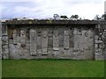
White Island lies just off the eastern shores of Lower Lough Erne. There is a roofless, ruined church with an arched Romanesque doorway, dating from 1200, earthworks of a 6th century monastery, a cross-slab and a number of interesting carved statues embedded into a wall. [Access to the island is by ferry from Castle Archdale Marina - Summer months only].
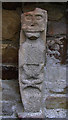
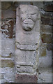
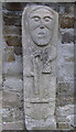
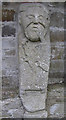
Inside the ruined church there are six carved figures, one uncarved, built into a wall dating from the 9th century. They all stare outward in a forward looking fashion with round-eyes and small mouths; their hands and feet are also quite small. They all wear long tunics indicating that most of them were ecclesiastics. All but one of the statues were discovered here in the early 19th century, the other one more recently in 1958.
From left to right figure no 1 probably represents a sheela-na-gig with a grinning face and crossed legs ? No 2 is a missionary carrying a book shrine. No 3 is a cleric, abbot or bishop holding a crozier. He could represent St Constan who founded the 6th century monastery here. Or, he could be a pilgrim with his staff and bag. No 4 is a figure carrying a pouch and short staff, pointing to his mouth (possibly the biblical David as a shepherd). No 5 a man with curly hair holding two gryphons by their necks seated on a chair (at the edge of the stone). No 6 is perhaps a warrior wearing a brooch on his left breast carrying a sword and shield. No 7 is an uncarved stone. Also, next to that there is the head of a frowning man wearing a flat cap or with a flat haircut ? but this figure is of a later date.
A small slab-stone or grave marker at the west side of the church has a simple cross carved onto it and a rather worn inscription; this was discovered in 1950. Of the 6th century monastery there is little to see apart from a boundary earthwork bank on the far side of the ruined church.
You may be viewing yesterday's version of this page. To see the most up to date information please register for a free account.
Do not use the above information on other web sites or publications without permission of the contributor.
Nearby Images from Geograph Britain and Ireland:
©2009(licence)
©2009(licence)
©2009(licence)
©2009(licence)
©2009(licence)
The above images may not be of the site on this page, they are loaded from Geograph.
Please Submit an Image of this site or go out and take one for us!
Click here to see more info for this site
Nearby sites
Click here to view sites on an interactive map of the areaKey: Red: member's photo, Blue: 3rd party photo, Yellow: other image, Green: no photo - please go there and take one, Grey: site destroyed
Download sites to:
KML (Google Earth)
GPX (GPS waypoints)
CSV (Garmin/Navman)
CSV (Excel)
To unlock full downloads you need to sign up as a Contributory Member. Otherwise downloads are limited to 50 sites.
Turn off the page maps and other distractions
Nearby sites listing. In the following links * = Image available
4.8km ENE 59° Kiltierney Stone Circle (H216625)
5.8km WNW 295° Cruninish Island Ring Barrow Round Barrow(s) (H12256239)
6.7km SSE 154° Killadeas Standing Stones (H205540)
6.7km SE 132° Cantytrindle Stone Row / Alignment (H225555)
7.7km NNW 348° Formil Multiple Stone Rows / Avenue (H159675)
7.7km ENE 75° Sheemuldoon Stone Circle (H250620)
7.8km NNW 348° Formil Stone Row / Alignment (H159676)
7.8km NNW 348° Formil Stone Circle (H159676)
9.2km WNW 283° Boa Island* Sculptured Stone (H08516198)
9.3km N 9° Montiaghroe NW Stone Row / Alignment (H190692)
9.3km N 10° Montiaghroe SW* Stone Circle
9.4km N 10° Montiaghroe SE Stone Circle (H191693)
9.5km NNE 12° Montiaghroe Stone Row / Alignment (H194693)
9.5km NNE 13° Montiaghroe, SE* Stone Row / Alignment (H197693)
9.6km N 11° Montiaghroe Centre* Stone Circle (H19326948)
11.0km NNE 14° Drumskinny* Stone Circle (H2008670721)
12.7km NNE 19° Meenacloy Standing Stones* Standing Stones
13.5km NNE 16° Scraghy SE Stone Circle (H211730)
13.5km SW 230° Doagh Glebe Promontory Fort / Cliff Castle (H0709051350)
13.6km SSW 194° Ross Lough Crannog (H14294677)
13.7km SW 226° Rossinure More Court Tomb (H07715039)
14.0km SSE 160° Lower Lough Erne Crannogs* Crannog (H224469)
14.2km SW 228° Rossinure Beg Court Tomb (H06915053)
14.5km SE 141° Breagho* Burial Chamber or Dolmen (H266487)
14.5km N 359° Cashelenny Stone Circle (H172745)
View more nearby sites and additional images


 We would like to know more about this location. Please feel free to add a brief description and any relevant information in your own language.
 Wir möchten mehr über diese Stätte erfahren. Bitte zögern Sie nicht, eine kurze Beschreibung und relevante Informationen in Deutsch hinzuzufügen.
 Nous aimerions en savoir encore un peu sur les lieux. S'il vous plaît n'hesitez pas à ajouter une courte description et tous les renseignements pertinents dans votre propre langue.
 Quisieramos informarnos un poco más de las lugares. No dude en añadir una breve descripción y otros datos relevantes en su propio idioma.