

<< Text Pages >> Idanha a Velha - Ancient Village or Settlement in Portugal in Castelo Branco
Submitted by holger_rix on Monday, 07 December 2015 Page Views: 852
Multi-periodSite Name: Idanha a VelhaCountry: Portugal
NOTE: This site is 13.025 km away from the location you searched for.
Distrito: Castelo Branco Type: Ancient Village or Settlement
Nearest Village: Idanha a Velha
Latitude: 39.996290N Longitude: 7.14491W
Condition:
| 5 | Perfect |
| 4 | Almost Perfect |
| 3 | Reasonable but with some damage |
| 2 | Ruined but still recognisable as an ancient site |
| 1 | Pretty much destroyed, possibly visible as crop marks |
| 0 | No data. |
| -1 | Completely destroyed |
| 5 | Superb |
| 4 | Good |
| 3 | Ordinary |
| 2 | Not Good |
| 1 | Awful |
| 0 | No data. |
| 5 | Can be driven to, probably with disabled access |
| 4 | Short walk on a footpath |
| 3 | Requiring a bit more of a walk |
| 2 | A long walk |
| 1 | In the middle of nowhere, a nightmare to find |
| 0 | No data. |
| 5 | co-ordinates taken by GPS or official recorded co-ordinates |
| 4 | co-ordinates scaled from a detailed map |
| 3 | co-ordinates scaled from a bad map |
| 2 | co-ordinates of the nearest village |
| 1 | co-ordinates of the nearest town |
| 0 | no data |
Be the first person to rate this site - see the 'Contribute!' box in the right hand menu.
Internal Links:
External Links:
Ancient Village or Settlement in Castelo Branco
You may be viewing yesterday's version of this page. To see the most up to date information please register for a free account.
Do not use the above information on other web sites or publications without permission of the contributor.
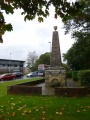
Nearby Images from Flickr
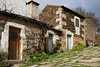
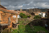
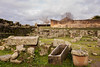
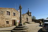
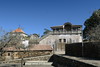
The above images may not be of the site on this page, but were taken nearby. They are loaded from Flickr so please click on them for image credits.
Click here to see more info for this site
Nearby sites
Click here to view sites on an interactive map of the areaKey: Red: member's photo, Blue: 3rd party photo, Yellow: other image, Green: no photo - please go there and take one, Grey: site destroyed
Download sites to:
KML (Google Earth)
GPX (GPS waypoints)
CSV (Garmin/Navman)
CSV (Excel)
To unlock full downloads you need to sign up as a Contributory Member. Otherwise downloads are limited to 50 sites.
Turn off the page maps and other distractions
Nearby sites listing. In the following links * = Image available
21.3km NE 56° Salvaleon Castro or Chafurdão
26.2km WNW 297° Castro da Covilhã Velha Castro or Chafurdão
26.3km SE 146° El Pizarron* Burial Chamber or Dolmen
27.1km SSE 148° Barcollero Burial Chamber or Dolmen
27.5km NE 41° El Palancar Burial Chamber or Dolmen
29.7km SSE 146° El Santo* Burial Chamber or Dolmen
30.4km S 172° Cabeço da Forca Burial Chamber or Dolmen
30.7km SSE 148° Cerro Conejo 2 Burial Chamber or Dolmen
30.7km SE 141° El Torruco Burial Chamber or Dolmen
30.7km SSE 148° Cerro Conejo 1 Burial Chamber or Dolmen
31.1km SSE 148° Retamar 4 Burial Chamber or Dolmen
31.2km SSE 148° Retamar 3 Burial Chamber or Dolmen
31.2km SSE 148° Retamar 2 Burial Chamber or Dolmen
31.3km SSE 148° Retamar 1 Burial Chamber or Dolmen
31.8km SSE 151° Carbonero Burial Chamber or Dolmen
32.0km S 176° Ovelheiros Burial Chamber or Dolmen
32.0km SE 143° La Llorona Burial Chamber or Dolmen
33.0km SE 141° Noguer Burial Chamber or Dolmen
33.1km SE 144° Menhir del Cabezo* Standing Stone (Menhir)
33.2km SE 143° El Cabezo Burial Chamber or Dolmen
33.8km SSE 156° Moheda Burial Chamber or Dolmen
34.6km SW 232° Castro do Monte de São Martinho Castro or Chafurdão
34.9km SSE 154° Cornejo Burial Chamber or Dolmen
36.7km SSE 157° San Martin Burial Chamber or Dolmen
36.7km SSE 157° Calderones Burial Chamber or Dolmen
View more nearby sites and additional images


 We would like to know more about this location. Please feel free to add a brief description and any relevant information in your own language.
 Wir möchten mehr über diese Stätte erfahren. Bitte zögern Sie nicht, eine kurze Beschreibung und relevante Informationen in Deutsch hinzuzufügen.
 Nous aimerions en savoir encore un peu sur les lieux. S'il vous plaît n'hesitez pas à ajouter une courte description et tous les renseignements pertinents dans votre propre langue.
 Quisieramos informarnos un poco más de las lugares. No dude en añadir una breve descripción y otros datos relevantes en su propio idioma.