


<< Our Photo Pages >> Kingsmountain Decorated Stone - Rock Art in Ireland (Republic of) in Co. Meath
Submitted by kith on Wednesday, 14 July 2021 Page Views: 761
Rock ArtSite Name: Kingsmountain Decorated Stone Alternative Name: Kingsmountain standing stoneCountry: Ireland (Republic of)
NOTE: This site is 10.779 km away from the location you searched for.
County: Co. Meath Type: Rock Art
Nearest Town: Oldcastle Nearest Village: Kingsmountain
Latitude: 53.761240N Longitude: 7.043041W
Condition:
| 5 | Perfect |
| 4 | Almost Perfect |
| 3 | Reasonable but with some damage |
| 2 | Ruined but still recognisable as an ancient site |
| 1 | Pretty much destroyed, possibly visible as crop marks |
| 0 | No data. |
| -1 | Completely destroyed |
| 5 | Superb |
| 4 | Good |
| 3 | Ordinary |
| 2 | Not Good |
| 1 | Awful |
| 0 | No data. |
| 5 | Can be driven to, probably with disabled access |
| 4 | Short walk on a footpath |
| 3 | Requiring a bit more of a walk |
| 2 | A long walk |
| 1 | In the middle of nowhere, a nightmare to find |
| 0 | No data. |
| 5 | co-ordinates taken by GPS or official recorded co-ordinates |
| 4 | co-ordinates scaled from a detailed map |
| 3 | co-ordinates scaled from a bad map |
| 2 | co-ordinates of the nearest village |
| 1 | co-ordinates of the nearest town |
| 0 | no data |
Internal Links:
External Links:
")
Access to the site is down a narrow lane next to a house at 53.76313 -7.03889.
About 300 m down the lane the stone will be found on the left about 40m from a farm gate.
From the National Monuments Service Archeological Survey of Ireland database:
ME010-027----
Today the decorated surface faces in a southerly direction, but as the stone has been re-erected, its original orientation is not known, nor can it be assumed that it was re-erected the correct way up. The chamber contained bones “all of which have disappeared”. The stone, rectangular in cross-section, is slightly over 2m in height and measures 0.85m in length at the base. The material is sandstone, the surface being uneven and flaked in places. Professor Phillips reports that “this stone is composed of well sorted cross-bedded quartz sandstone with a few circular calcareous concretions. This rock is of Lower Carboniferous age and could have been quarried in the Oldcastle area to the west.” The decoration is confined to the lower half of one of the two broad faces where it occupies virtually the entire surface. The motifs consist almost entirely of spirals. These are six in number. The bottom two are anti-clockwise; the remainder are clockwise. There are three main spirals and these extend diagonally along the face from top to bottom. The uppermost spiral is of four turns but portion of the top is now missing. At its base there are two sagging lines; perhaps these are all that remain of two further members. To its upper left there are traces of a curvilinear motif. The middle spiral consists of seven turns. The bottom example has five turns. It has been damaged due to the removal of part of the stone's surface, especially on the right hand side. To the left of the central spiral there are three further spirals, but smaller and not so well preserved. That on the top has four turns; the middle has three and the bottom possibly five. To the bottom right of the large uppermost spiral there are two further lines. These are parallel and almost vertical. Between the outermost one and the edge there appears to be same slight depressions, possibly pickmarks.’ (Moore 1987, no. 26; Herity 1974, 244; Shee Twohig 1981, 224-5; Eogan 2000, 4-6)
Compiled by: Paul Walsh
Date of upload: 21 April 2015
References:
1. Eogan, G. 2000 A group of Megalithic monuments at Kingsmountain - Clonasillagh, Co. Meath, Ríocht na Mídhe, 11, 1016.
2. Herity, M. 1974 Irish Passage Graves. Dublin. Irish University Press.
3. Moore, M. 1987 Archaeological inventory of county Meath. Dublin. Stationery Office.
4. Shee Twohig, E. 1981 The Megalithic Art of Western Europe. Oxford, Clarendon Press src="> src="> src=">
You may be viewing yesterday's version of this page. To see the most up to date information please register for a free account.
")
")
")
Do not use the above information on other web sites or publications without permission of the contributor.
Nearby Images from Flickr
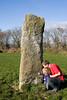
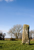
The above images may not be of the site on this page, but were taken nearby. They are loaded from Flickr so please click on them for image credits.
Click here to see more info for this site
Nearby sites
Click here to view sites on an interactive map of the areaKey: Red: member's photo, Blue: 3rd party photo, Yellow: other image, Green: no photo - please go there and take one, Grey: site destroyed
Download sites to:
KML (Google Earth)
GPX (GPS waypoints)
CSV (Garmin/Navman)
CSV (Excel)
To unlock full downloads you need to sign up as a Contributory Member. Otherwise downloads are limited to 50 sites.
Turn off the page maps and other distractions
Nearby sites listing. In the following links * = Image available
4.0km WSW 247° Cairn X1* Passage Grave (N595779)
4.4km WSW 250° Ballinvally ME009-084 Rock Art (N5900377909)
4.8km WSW 248° Loughcrew Cairn W* Passage Grave
4.9km WSW 248° Loughcrew Cairn V* Passage Grave
4.9km WSW 248° Loughcrew Cairn U* Passage Grave (N5862977605)
4.9km WSW 248° Loughcrew Cairn T* Chambered Cairn (N5860477578)
4.9km WSW 248° Loughcrew Cairn S* Passage Grave (N5857577584)
5.1km W 260° Ballinvalley* Stone Circle (N581785)
6.3km WSW 252° Loughcrew Cairn L* Chambered Cairn (N5719877410)
6.4km WSW 251° Carbane West Chambered Cairn (N571773)
7.9km N 359° Fort Williams Stone Fort or Dun
10.3km WNW 289° Farranaglogh Standing Stones
18.2km SE 146° Tlachtga* Hillfort
25.5km ESE 118° Donaghmore Stone Circle (N860680)
27.1km ENE 73° Garret's Stone Standing Stone (Menhir) (N891877)
27.8km W 275° Cartronbore Stone Circle
29.7km NNE 19° Lisnadarragh Wedge Tomb Wedge Tomb (H724077)
31.2km SW 221° St Brigid's Well, Cullion* Holy Well or Sacred Spring (N42925570)
31.4km E 89° Grangegeeth Sculptured Stone
32.0km ENE 76° Hurlstone* Holed Stone (N9426987509)
32.9km NNW 330° Shantemon Stone Row / Alignment (H4642707815)
33.0km N 3° Cohaw* Court Tomb
33.1km E 98° Hill of Slane* Artificial Mound
34.9km SE 125° Blocc and Bluigne* Standing Stones (N9206359823)
34.9km SE 125° Hill of Tara* Passage Grave (N9201659707)
View more nearby sites and additional images


 We would like to know more about this location. Please feel free to add a brief description and any relevant information in your own language.
 Wir möchten mehr über diese Stätte erfahren. Bitte zögern Sie nicht, eine kurze Beschreibung und relevante Informationen in Deutsch hinzuzufügen.
 Nous aimerions en savoir encore un peu sur les lieux. S'il vous plaît n'hesitez pas à ajouter une courte description et tous les renseignements pertinents dans votre propre langue.
 Quisieramos informarnos un poco más de las lugares. No dude en añadir una breve descripción y otros datos relevantes en su propio idioma.