 with our Megalithic Portal iPhone app")

<< Our Photo Pages >> Rath Lugh - Promontory Fort / Cliff Castle in Ireland (Republic of) in Co. Meath
Submitted by Andy B on Sunday, 23 March 2008 Page Views: 9385
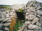
Iron Age and Later PrehistorySite Name: Rath LughCountry: Ireland (Republic of)
NOTE: This site is 1.63 km away from the location you searched for.
County: Co. Meath Type: Promontory Fort / Cliff Castle
Nearest Town: Navan Nearest Village: Lismullen
Map Ref: N939613
Latitude: 53.593339N Longitude: 6.582601W
Condition:
| 5 | Perfect |
| 4 | Almost Perfect |
| 3 | Reasonable but with some damage |
| 2 | Ruined but still recognisable as an ancient site |
| 1 | Pretty much destroyed, possibly visible as crop marks |
| 0 | No data. |
| -1 | Completely destroyed |
| 5 | Superb |
| 4 | Good |
| 3 | Ordinary |
| 2 | Not Good |
| 1 | Awful |
| 0 | No data. |
| 5 | Can be driven to, probably with disabled access |
| 4 | Short walk on a footpath |
| 3 | Requiring a bit more of a walk |
| 2 | A long walk |
| 1 | In the middle of nowhere, a nightmare to find |
| 0 | No data. |
| 5 | co-ordinates taken by GPS or official recorded co-ordinates |
| 4 | co-ordinates scaled from a detailed map |
| 3 | co-ordinates scaled from a bad map |
| 2 | co-ordinates of the nearest village |
| 1 | co-ordinates of the nearest town |
| 0 | no data |
Internal Links:
External Links:
I have visited· I would like to visit
kith visited on 1st Sep 2007 - their rating: Cond: -1 Amb: 1 Site deliberately destroyed to built the M3 motorway. Many outlying sites lost too.
Andy B have visited here
")
More information and photos at Mythical Ireland.
Note: Rath Lugh / M3 update, see comment
You may be viewing yesterday's version of this page. To see the most up to date information please register for a free account.
")
")
Do not use the above information on other web sites or publications without permission of the contributor.
Nearby Images from Geograph Britain and Ireland:
©2011(licence)
©2010(licence)
©2010(licence)

©2012(licence)
©2013(licence)
The above images may not be of the site on this page, they are loaded from Geograph.
Please Submit an Image of this site or go out and take one for us!
Click here to see more info for this site
Nearby sites
Click here to view sites on an interactive map of the areaKey: Red: member's photo, Blue: 3rd party photo, Yellow: other image, Green: no photo - please go there and take one, Grey: site destroyed
Download sites to:
KML (Google Earth)
GPX (GPS waypoints)
CSV (Garmin/Navman)
CSV (Excel)
To unlock full downloads you need to sign up as a Contributory Member. Otherwise downloads are limited to 50 sites.
Turn off the page maps and other distractions
Nearby sites listing. In the following links * = Image available
544m WNW 300° Lismullin Henge Henge (N93426156)
2.4km SW 232° Blocc and Bluigne* Standing Stones (N9206359823)
2.5km SW 231° Hill of Tara* Passage Grave (N9201659707)
2.5km SW 230° Lia Fail* Standing Stone (Menhir) (N9197659625)
2.9km SW 222° Tuath Linde* Holy Well or Sacred Spring (N920591)
3.3km SSW 210° Rath Maeve* Henge
6.2km SSE 153° Moyer Carns Cairn
7.9km S 174° Moybologue Cemetery Artificial Mound
8.9km ESE 116° Kilbrew Henge
10.3km NW 312° Donaghmore Stone Circle (N860680)
12.6km NNE 33° Recently Discovered Prehistoric Cropmark near Newgrange* Misc. Earthwork
13.3km NNE 32° Newgrange Stone Circle* Stone Circle (O007727)
13.3km NNE 32° Newgrange* Passage Grave (O00747272)
13.4km NNE 27° Knowth Timber Circle* Timber Circle (N997734)
13.4km NNE 27° Knowth* Passage Grave (N99697342)
13.6km NE 36° Newgrange Standing Stones* Standing Stones
14.0km N 10° Hill of Slane* Artificial Mound
15.0km NE 35° Dowth Passage Grave* Passage Grave (O02377377)
15.4km NE 39° Donore Mystery Mound Artificial Mound (O0334573550)
15.6km NE 37° Dowth Hall* Passage Grave
16.0km NE 37° Dowth Henge* Henge (O034742)
16.5km E 85° Micknanstown* Passage Grave
16.6km NNE 31° Townleyhall Passage Tomb* Passage Grave (O0222075723)
16.9km E 89° Fourknocks* Passage Grave (O10856202)
17.2km E 83° Greenanstown Stone Circle (O110637)
View more nearby sites and additional images


 We would like to know more about this location. Please feel free to add a brief description and any relevant information in your own language.
 Wir möchten mehr über diese Stätte erfahren. Bitte zögern Sie nicht, eine kurze Beschreibung und relevante Informationen in Deutsch hinzuzufügen.
 Nous aimerions en savoir encore un peu sur les lieux. S'il vous plaît n'hesitez pas à ajouter une courte description et tous les renseignements pertinents dans votre propre langue.
 Quisieramos informarnos un poco más de las lugares. No dude en añadir una breve descripción y otros datos relevantes en su propio idioma.