


<< Our Photo Pages >> Vicar's Cairn - Passage Grave in Ireland (Northern) in Co. Armagh
Submitted by Stone Free on Thursday, 28 December 2023 Page Views: 121
Neolithic and Bronze AgeSite Name: Vicar's Cairn Alternative Name: Monk's Cairn, CarnavanaghanCountry: Ireland (Northern) County: Co. Armagh Type: Passage Grave
Nearest Town: Portadown Nearest Village: Armagh
Latitude: 54.298400N Longitude: 6.59678W
Condition:
| 5 | Perfect |
| 4 | Almost Perfect |
| 3 | Reasonable but with some damage |
| 2 | Ruined but still recognisable as an ancient site |
| 1 | Pretty much destroyed, possibly visible as crop marks |
| 0 | No data. |
| -1 | Completely destroyed |
| 5 | Superb |
| 4 | Good |
| 3 | Ordinary |
| 2 | Not Good |
| 1 | Awful |
| 0 | No data. |
| 5 | Can be driven to, probably with disabled access |
| 4 | Short walk on a footpath |
| 3 | Requiring a bit more of a walk |
| 2 | A long walk |
| 1 | In the middle of nowhere, a nightmare to find |
| 0 | No data. |
| 5 | co-ordinates taken by GPS or official recorded co-ordinates |
| 4 | co-ordinates scaled from a detailed map |
| 3 | co-ordinates scaled from a bad map |
| 2 | co-ordinates of the nearest village |
| 1 | co-ordinates of the nearest town |
| 0 | no data |
Internal Links:
External Links:
")
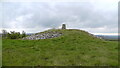
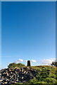
Previous entry for this site by Anonymous is totally off so here's an update of precise location, description and some pics.
The cairn is not destroyed...it survives to a height of 4 metres on the south side but a lot of the north side is in a pretty bad shape. No sign of decorated kerb stones as stated in old records. A small modern rectangular structure at the base of the cairn has almost been reclaimed by nature.
The cairn is a scheduled monument
Note: Original page # 1335 deleted, saved as PDF [johnstone]
You may be viewing yesterday's version of this page. To see the most up to date information please register for a free account.
")
")
Do not use the above information on other web sites or publications without permission of the contributor.
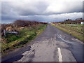
Nearby Images from Geograph Britain and Ireland:
©2021(licence)
©2008(licence)
©2008(licence)
©2008(licence)
©2008(licence)
The above images may not be of the site on this page, they are loaded from Geograph.
Please Submit an Image of this site or go out and take one for us!
Click here to see more info for this site
Nearby sites
Click here to view sites on an interactive map of the areaKey: Red: member's photo, Blue: 3rd party photo, Yellow: other image, Green: no photo - please go there and take one, Grey: site destroyed
Download sites to:
KML (Google Earth)
GPX (GPS waypoints)
CSV (Garmin/Navman)
CSV (Excel)
To unlock full downloads you need to sign up as a Contributory Member. Otherwise downloads are limited to 50 sites.
Turn off the page maps and other distractions
Nearby sites listing. In the following links * = Image available
2.7km WSW 244° Bull's Stone (Ballymacnab)* Ancient Cross (H89033855)
8.5km NW 310° Navan Site B Timber Circle (H848451)
8.5km NW 307° Navan Centre Museum
8.6km NW 310° Navan Fort* Henge (H847452)
9.7km NW 311° Ballybrolly Stone Circle (H840460)
15.8km SE 137° Eswary Stone Row* Stone Row / Alignment (J025285)
15.8km SE 136° Eswary Court Tomb* Court Tomb (J0270428676)
18.8km E 87° The Three Sisters* Stone Row / Alignment
19.3km SSE 149° Ballard Longstone* Standing Stone (Menhir) (J01622337)
19.6km ESE 105° Donaghmore High Cross Ancient Cross (J1044334964)
19.6km SSE 152° St Moninna's Holy Well (Killevy)* Holy Well or Sacred Spring (J010226)
19.7km E 86° Drumnahare* Standing Stone (Menhir) (J111415)
19.8km SSE 157° Latbirget Court Tomb (H9940821636)
20.1km SSE 157° Ballykeel* Portal Tomb (H9952721328)
20.2km N 5° Derrycaw Standing Stone* Standing Stone (Menhir) (H928599)
20.9km SSE 157° The Oul Grave Portal Tomb (H9991820624)
21.6km SSE 157° Aughadave Stone Row / Alignment (J0034020070)
21.8km SE 137° Ballymacdermot* Court Tomb (J06562403)
21.9km S 184° Annaghmare* Court Tomb (H9049017820)
22.3km SSE 152° Slieve Gullion* Chambered Tomb (J02482033)
22.3km ESE 114° Killybeg* Standing Stones (J121312)
22.4km ESE 114° Saval More Stone Pair* Standing Stones
23.6km SW 227° Lennan Portal Tomb Portal Tomb (H74502324)
23.8km ESE 121° Crobane* Standing Stone (Menhir) (J121279)
24.1km S 183° Crossmaglen Standing Stones (H9078015680)
View more nearby sites and additional images


 We would like to know more about this location. Please feel free to add a brief description and any relevant information in your own language.
 Wir möchten mehr über diese Stätte erfahren. Bitte zögern Sie nicht, eine kurze Beschreibung und relevante Informationen in Deutsch hinzuzufügen.
 Nous aimerions en savoir encore un peu sur les lieux. S'il vous plaît n'hesitez pas à ajouter une courte description et tous les renseignements pertinents dans votre propre langue.
 Quisieramos informarnos un poco más de las lugares. No dude en añadir una breve descripción y otros datos relevantes en su propio idioma.