 with our Megalithic Portal iPhone app")


<< Our Photo Pages >> Clochafarmore - Standing Stone (Menhir) in Ireland (Republic of) in Co. Louth
Submitted by DrewParsons on Monday, 05 July 2010 Page Views: 6871
Neolithic and Bronze AgeSite Name: Clochafarmore Alternative Name: CuChulain's StoneCountry: Ireland (Republic of)
NOTE: This site is 8.524 km away from the location you searched for.
County: Co. Louth Type: Standing Stone (Menhir)
Nearest Town: Ardee Nearest Village: Rathiddy
Map Ref: J007039
Latitude: 53.974674N Longitude: 6.466044W
Condition:
| 5 | Perfect |
| 4 | Almost Perfect |
| 3 | Reasonable but with some damage |
| 2 | Ruined but still recognisable as an ancient site |
| 1 | Pretty much destroyed, possibly visible as crop marks |
| 0 | No data. |
| -1 | Completely destroyed |
| 5 | Superb |
| 4 | Good |
| 3 | Ordinary |
| 2 | Not Good |
| 1 | Awful |
| 0 | No data. |
| 5 | Can be driven to, probably with disabled access |
| 4 | Short walk on a footpath |
| 3 | Requiring a bit more of a walk |
| 2 | A long walk |
| 1 | In the middle of nowhere, a nightmare to find |
| 0 | No data. |
| 5 | co-ordinates taken by GPS or official recorded co-ordinates |
| 4 | co-ordinates scaled from a detailed map |
| 3 | co-ordinates scaled from a bad map |
| 2 | co-ordinates of the nearest village |
| 1 | co-ordinates of the nearest town |
| 0 | no data |
Internal Links:
External Links:
I have visited· I would like to visit
rrmoser would like to visit
Andy B DrewParsons have visited here
")
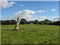
Clochafarmore is a three metre tall standing stone near the village of Rathiddy which is to the south west of Dundalk. The stone is on a ridge approximately 100 metres to the east of the Dundalk to Ardee road and is accessed by a footpath although parking was problematical when I visited the area in October 2008.
The stone is traditionally associated with CuChulain who is credited with holding off Queen Maeve of Connacht's army and when all was lost and he wounded he had himself tied to the stone to face his enemies in one last stand. His enemies feared to approach him until after three days a raven landed on his head which gave away the fact that he had died.
My photo was taken from the road as it was getting late, was raining and there was no safe place to park so it is of poor quality.
You may be viewing yesterday's version of this page. To see the most up to date information please register for a free account.
")
Do not use the above information on other web sites or publications without permission of the contributor.
davidmorgan has found this location on Google Street View:
Nearby Images from Geograph Britain and Ireland:
©2007(licence)
©2016(licence)
©2016(licence)
©2016(licence)
©2016(licence)
The above images may not be of the site on this page, they are loaded from Geograph.
Please Submit an Image of this site or go out and take one for us!
Click here to see more info for this site
Nearby sites
Click here to view sites on an interactive map of the areaKey: Red: member's photo, Blue: 3rd party photo, Yellow: other image, Green: no photo - please go there and take one, Grey: site destroyed
Download sites to:
KML (Google Earth)
GPX (GPS waypoints)
CSV (Garmin/Navman)
CSV (Excel)
To unlock full downloads you need to sign up as a Contributory Member. Otherwise downloads are limited to 50 sites.
Turn off the page maps and other distractions
Nearby sites listing. In the following links * = Image available
5.0km NW 306° Ballinloughan* Rock Art (H966067)
6.1km N 4° Killin Stone Circle (J010100)
6.3km NNE 16° Balregan Standing Stones (J023100)
7.0km NNE 31° Carn Beg Stone Circle
8.9km NNW 342° Edenakill Stone Row / Alignment (H978123)
9.0km NNE 12° Carrickedmond E Stone Row / Alignment (J024128)
9.1km NNE 13° Carrickedmond W Stone Row / Alignment (J026128)
10.1km NE 56° Bellurgan Stone Circle (J090097)
10.4km NE 48° Proleek Dolmen* Portal Tomb (J0826511033)
10.4km NE 48° Proleek Wedge Tomb* Wedge Tomb (J0833611000)
11.9km NE 36° Aghadh Na Sceach* Chambered Tomb
12.2km NNE 27° Kilnasaggart Pillar Stone* Early Christian Sculptured Stone (J061149)
12.5km ENE 72° Rockmarshall Court Tomb
13.8km NE 41° Ravensdale Dolmen Burial Chamber or Dolmen (J0962314529)
13.9km NE 34° Ravensdale Park* Modern Stone Circle etc (J083156)
14.9km NE 39° Ravensdale Park Stone Row / Alignment (J098157)
15.4km NW 321° Crossmaglen Standing Stones (H9078015680)
16.2km N 360° Aughadave Stone Row / Alignment (J0034020070)
16.5km N 7° Slieve Gullion* Chambered Tomb (J02482033)
16.7km N 359° The Oul Grave Portal Tomb (H9991820624)
17.2km NW 325° Annaghmare* Court Tomb (H9049017820)
17.4km N 357° Ballykeel* Portal Tomb (H9952721328)
17.6km SSW 203° Hurlstone* Holed Stone (N9426987509)
17.8km N 357° Latbirget Court Tomb (H9940821636)
18.0km NNE 32° Clontygora* Court Tomb (J0986519419)
View more nearby sites and additional images


 We would like to know more about this location. Please feel free to add a brief description and any relevant information in your own language.
 Wir möchten mehr über diese Stätte erfahren. Bitte zögern Sie nicht, eine kurze Beschreibung und relevante Informationen in Deutsch hinzuzufügen.
 Nous aimerions en savoir encore un peu sur les lieux. S'il vous plaît n'hesitez pas à ajouter une courte description et tous les renseignements pertinents dans votre propre langue.
 Quisieramos informarnos un poco más de las lugares. No dude en añadir una breve descripción y otros datos relevantes en su propio idioma.