Featured: How and why the ancients enchanted Great Britain and Brittany

How and why the ancients enchanted Great Britain and Brittany

Ancestral Geographies of the Neolithic, Edmonds, Bender

Ancestral Geographies of the Neolithic, Edmonds, Bender

Who's Online

There are currently, 354 guests and 4 members online.

You are a guest. To join in, please register for free by clicking here

Sponsors

<< Our Photo Pages >> Fourknocks - Passage Grave in Ireland (Republic of) in Co. Meath

Submitted by Anthony_Weir on Sunday, 13 October 2002  Page Views: 14925

Neolithic and Bronze AgeSite Name: Fourknocks
Country: Ireland (Republic of) County: Co. Meath Type: Passage Grave
Nearest Town: Balbriggan  Nearest Village: Naul
Map Ref: O10856202
Discovery Map Number: D43
Latitude: 53.596499N  Longitude: 6.326466W
Condition:
5Perfect
4Almost Perfect
3Reasonable but with some damage
2Ruined but still recognisable as an ancient site
1Pretty much destroyed, possibly visible as crop marks
0No data.
-1Completely destroyed
3 Ambience:
5Superb
4Good
3Ordinary
2Not Good
1Awful
0No data.
5 Access:
5Can be driven to, probably with disabled access
4Short walk on a footpath
3Requiring a bit more of a walk
2A long walk
1In the middle of nowhere, a nightmare to find
0No data.
4 Accuracy:
5co-ordinates taken by GPS or official recorded co-ordinates
4co-ordinates scaled from a detailed map
3co-ordinates scaled from a bad map
2co-ordinates of the nearest village
1co-ordinates of the nearest town
0no data
5

Internal Links:
External Links:

I have visited· I would like to visit

KieKa rrmoser would like to visit

Catrinm visited on 25th Mar 2024 - their rating: Cond: 4 Amb: 5 Access: 4 Amazing private visit. Key is available from a house/ bungalow about a mile away ( the Whites) for a deposit. Look up the postcode on Meath council website, as it is not given on the sign.

jeffrep visited on 17th Apr 2009 - their rating: Cond: 3 Amb: 5 Access: 4

coin visited - their rating: Cond: 3 Amb: 3 Access: 4

neolithique02 DrewParsons davidmorgan have visited here

Average ratings for this site from all visit loggers: Condition: 3.33 Ambience: 4.33 Access: 4

Fourknocks
Fourknocks submitted by kenwilliams : An extremely wide lens fits in just about the entire chamber, taken from the short passageway. Note the carvings on the free standing stone to the right. The light is natural light from the ingeniously placed holes in the modern roofing. (Vote or comment on this photo)
Passage Grave in Co. Meath 3.2 km WNW of the village of (The) Naul, along a short track leading from a by-road. A notice is displayed stating where the key can be obtained.

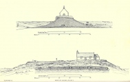
A fine cruciform tomb, excavated, and now preserved under a concrete shell dome grassed over, is imaginatively lit by slits above the decorated lintels of the three recesses. It is quite in contrast to the Disneyfication that has occurred at Newgrange. The original tomb was probably roofed with timber and sods. There are 12 fine decorated stones: one upright one has a stylised human face.
You may be viewing yesterday's version of this page. To see the most up to date information please register for a free account.


Fourknocks
Fourknocks submitted by Catrinm : Carved Capstones of portals at Fourknocks (Vote or comment on this photo)

Fourknocks
Fourknocks submitted by Catrinm (Vote or comment on this photo)

Fourknocks
Fourknocks submitted by neolithique02 : Fourknocks One of the few antropomorphic stone in Ireland Image copyright: Néolithique02, hosted on Flickr and displayed under the terms of their API. (Vote or comment on this photo)

Fourknocks
Fourknocks submitted by neolithique02 : Fourknocks Image copyright: Néolithique02, hosted on Flickr and displayed under the terms of their API. (Vote or comment on this photo)

Fourknocks
Fourknocks submitted by neolithique02 : Fourknocks Image copyright: Néolithique02, hosted on Flickr and displayed under the terms of their API. (Vote or comment on this photo)

Fourknocks
Fourknocks submitted by neolithique02 (1 comment)

Fourknocks
Fourknocks submitted by neolithique02

Fourknocks
Fourknocks submitted by neolithique02

Fourknocks
Fourknocks submitted by neolithique02 : Fourknocks Do you speak Fourknocks ? Image copyright: Néolithique02, hosted on Flickr and displayed under the terms of their API.

Fourknocks
Fourknocks submitted by Bladup : Rock Art at Fourknocks.

Fourknocks
Fourknocks submitted by Bladup

Fourknocks
Fourknocks submitted by Bladup

Fourknocks
Fourknocks submitted by Anthony_Weir : Photo by Anthony Weir

Fourknocks
Fourknocks submitted by DrewParsons : The chamber showing both decorated lintels above their respective alcoves. The black area at the top of the photo is the artificial roof installed after excavation. October 2010.

Fourknocks
Fourknocks submitted by DrewParsons : The second richly decorated lintel above an alcove. October 2010.

Fourknocks
Fourknocks submitted by DrewParsons : The feet or claws on the lower part of the anthropomorphic figure towards the side of the chamber's entrance area. October 2010.

Fourknocks
Fourknocks submitted by DrewParsons : An anthropomorphic figure on a side stone in the chamber. October 2010.

Fourknocks
Fourknocks submitted by DrewParsons : One of two decorated lintels. October 2010.

Fourknocks
Fourknocks submitted by DrewParsons : An alcove with a magnificently decorated lintel. October 2010.

Fourknocks
Fourknocks submitted by DrewParsons : Detail from one of the lintels. October 2010.

Fourknocks
Fourknocks submitted by DrewParsons : Decorative carvings on a stone in the passage into the chamber. October 2010.

Fourknocks
Fourknocks submitted by DrewParsons : The mound. Entrance is by key obtainable from a nearby resident. Details are on the sign by the site. October 2010.

Fourknocks
Fourknocks submitted by DrewParsons : The site sign. October 2010.

Fourknocks
Fourknocks submitted by Sunny100 : View of Fourknocks passage grave near Naul. It dates from the Neolithic period 5,000 years ago. A grassy mound with a 17 foot long passage-way inside that leads to a chamber 21 foot across. Inside there are some decorated stones with zigzag and circular carvings, one stone 3 foot high, has a face on it. 65 burials were excavated in the chamber as well as pottery, vessels and personal effects.

Fourknocks
Fourknocks submitted by jeffrep : View to the Exit, Fourknocks, County Meath, Ireland.

These are just the first 25 photos of Fourknocks. If you log in with a free user account you will be able to see our entire collection.

Do not use the above information on other web sites or publications without permission of the contributor.
Click here to see more info for this site

Nearby sites

Click here to view sites on an interactive map of the area

Key: Red: member's photo, Blue: 3rd party photo, Yellow: other image, Green: no photo - please go there and take one, Grey: site destroyed

Download sites to:
KML (Google Earth)
GPX (GPS waypoints)
CSV (Garmin/Navman)
CSV (Excel)

To unlock full downloads you need to sign up as a Contributory Member. Otherwise downloads are limited to 50 sites.


Turn off the page maps and other distractions

Nearby sites listing. In the following links * = Image available
 1.1km NNW 336° Micknanstown* Passage Grave
 1.7km N 6° Greenanstown Stone Circle (O110637)
 8.4km ENE 60° Knocknagin* Passage Grave
 9.7km ENE 67° Bremore Port* Passage Grave
 9.9km WSW 245° Kilbrew Henge
 12.9km N 353° Millmount* Artificial Mound
 13.7km NNW 328° Donore Mystery Mound Artificial Mound (O0334573550)
 14.0km NW 320° Newgrange Standing Stones* Standing Stones
 14.2km NNW 328° Dowth Hall* Passage Grave
 14.3km NNW 330° Dowth Henge* Henge (O034742)
 14.4km NW 315° Recently Discovered Prehistoric Cropmark near Newgrange* Misc. Earthwork
 14.5km NNW 340° Oldbridge Logboat, River Boyne Not Known (by us)
 14.5km NW 326° Dowth Passage Grave* Passage Grave (O02377377)
 14.7km NW 318° Newgrange* Passage Grave (O00747272)
 14.7km NW 318° Newgrange Stone Circle* Stone Circle (O007727)
 15.3km WSW 247° Moyer Carns Cairn
 15.9km NW 317° Knowth Timber Circle* Timber Circle (N997734)
 15.9km NW 317° Knowth* Passage Grave (N99697342)
 16.2km NNW 329° Townleyhall Passage Tomb* Passage Grave (O0222075723)
 16.5km NNE 14° Baltray* Standing Stones
 16.7km E 94° St Patrick's Island Early Christian Sculptured Stone
 16.9km W 269° Rath Lugh* Promontory Fort / Cliff Castle (N939613)
 17.4km W 270° Lismullin Henge Henge (N93426156)
 18.1km WSW 243° Moybologue Cemetery Artificial Mound
 18.8km W 260° Rath Maeve* Henge
View more nearby sites and additional images

<< Brennanstown

Howth >>

Please add your thoughts on this site

Clickable Map of Ireland

Newgrange: Archaeology, Art and Legend

Newgrange: Archaeology, Art and Legend

Sponsors

Auto-Translation (Google)

Translate from English into:

"Fourknocks" | Login/Create an Account | 4 News and Comments
  
Go back to top of page    Comments are owned by the poster. We aren't responsible for their content.
Re: Fourknocks by Catrinm on Tuesday, 02 April 2024
(User Info | Send a Message)
Well wirth a visit if in Newgrange area - and free
[ Reply to This ]

Re: Fourknocks by Andy B on Monday, 07 May 2018
(User Info | Send a Message)
National Monuments Service:
Class Megalithic tomb - passage tomb
Townland FOURKNOCKS
SMR No. ME033-028001-
Description The following description is derived from the published 'Archaeological Inventory of County Meath' (Dublin: Stationery Office, 1987). In certain instances the entries have been revised and updated in the light of recent research. Date of upload/revision: 10 July 2007 Excavated in 1950-2, the mound, 19m in diam. and delimited by a low dry-walled kerb, contained a curciform passage-tomb opening to NNE. Three recesses open off the large pear-shaped central chamber, 6.5m by 7.5m, now covered by a shell-concrete dome. Twelve structural stones bear megalithic art. Cemetery mound (ME033-028002-) and cists and pits (ME033-028004-) related to megalithic tomb. (Herity 1974, 253-4; Shee 1981, 220-2)
[ Reply to This ]

Re: Fourknocks by SumDoood on Saturday, 31 January 2015
(User Info | Send a Message)
I was very interested to read that "The original tomb was probably roofed with timber and sods." I had wondered if this was the case at Cairnholy 1 in Galloway also. How common is this thought to be? And what helps to indicate that it might have been so?
[ Reply to This ]

Re: Fourknocks by davidmorgan on Sunday, 21 October 2012
(User Info | Send a Message)
Street View -
View Larger Map
[ Reply to This ]

Your Name: Anonymous [ Register Now ]
Subject:


Add your comment or contribution to this page. Spam or offensive posts are deleted immediately, don't even bother

<<< What is five plus one as a number? (Please type the answer to this question in the little box on the left)
You can also embed videos and other things. For Youtube please copy and paste the 'embed code'.
For Google Street View please include Street View in the text.
Create a web link like this: <a href="https://www.megalithic.co.uk">This is a link</a>  

Allowed HTML is:
<p> <b> <i> <a> <img> <em> <br> <strong> <blockquote> <tt> <li> <ol> <ul> <object> <param> <embed> <iframe>

We would like to know more about this location. Please feel free to add a brief description and any relevant information in your own language.
Wir möchten mehr über diese Stätte erfahren. Bitte zögern Sie nicht, eine kurze Beschreibung und relevante Informationen in Deutsch hinzuzufügen.
Nous aimerions en savoir encore un peu sur les lieux. S'il vous plaît n'hesitez pas à ajouter une courte description et tous les renseignements pertinents dans votre propre langue.
Quisieramos informarnos un poco más de las lugares. No dude en añadir una breve descripción y otros datos relevantes en su propio idioma.