


<< Our Photo Pages >> Rendalen Hut Site - Ancient Village or Settlement in Greenland
Submitted by DrewParsons on Wednesday, 09 October 2013 Page Views: 4979
Multi-periodSite Name: Rendalen Hut SiteCountry: Greenland
NOTE: This site is 59.593 km away from the location you searched for.
Type: Ancient Village or Settlement
Nearest Town: Ittoqqortoormiit
Latitude: 73.342000N Longitude: 26.503W
Condition:
| 5 | Perfect |
| 4 | Almost Perfect |
| 3 | Reasonable but with some damage |
| 2 | Ruined but still recognisable as an ancient site |
| 1 | Pretty much destroyed, possibly visible as crop marks |
| 0 | No data. |
| -1 | Completely destroyed |
| 5 | Superb |
| 4 | Good |
| 3 | Ordinary |
| 2 | Not Good |
| 1 | Awful |
| 0 | No data. |
| 5 | Can be driven to, probably with disabled access |
| 4 | Short walk on a footpath |
| 3 | Requiring a bit more of a walk |
| 2 | A long walk |
| 1 | In the middle of nowhere, a nightmare to find |
| 0 | No data. |
| 5 | co-ordinates taken by GPS or official recorded co-ordinates |
| 4 | co-ordinates scaled from a detailed map |
| 3 | co-ordinates scaled from a bad map |
| 2 | co-ordinates of the nearest village |
| 1 | co-ordinates of the nearest town |
| 0 | no data |
Internal Links:
External Links:
I have visited· I would like to visit
DrewParsons has visited here
")
The hut foundations just above the beach at Rendalen, in Isfjord, North East Greenland are dated to around 800 years ago. They represent the remains of the accommodation of Thule culture hunters who have long since departed from this remote area. The site is only accessible by ship for a couple of summer months a year due to ice conditions, or by multi day dog sled trip at other times as there are no nearby settlements.
You may be viewing yesterday's version of this page. To see the most up to date information please register for a free account.
")
")
")
")
Do not use the above information on other web sites or publications without permission of the contributor.
Nearby Images from Flickr
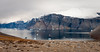
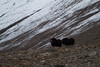
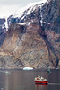
The above images may not be of the site on this page, but were taken nearby. They are loaded from Flickr so please click on them for image credits.
Click here to see more info for this site
Nearby sites
Click here to view sites on an interactive map of the areaKey: Red: member's photo, Blue: 3rd party photo, Yellow: other image, Green: no photo - please go there and take one, Grey: site destroyed
Download sites to:
KML (Google Earth)
GPX (GPS waypoints)
CSV (Garmin/Navman)
CSV (Excel)
To unlock full downloads you need to sign up as a Contributory Member. Otherwise downloads are limited to 50 sites.
Turn off the page maps and other distractions
Nearby sites listing. In the following links * = Image available
322.0km S 178° Danmark Ø Hut Foundations* Ancient Village or Settlement
853.3km SSE 147° Þorgeirsdys Cairn
861.9km SSE 147° Arctic Henge Modern Stone Circle etc
878.1km S 170° Flókatóftir Ancient Village or Settlement
900.4km SSE 155° Eyjafjörður Fjord* Artificial Mound
903.7km SSE 162° Borgarvirki* Promontory Fort / Cliff Castle
934.4km S 169° Helgafell Natural Stone / Erratic / Other Natural Feature
980.6km WSW 254° Ilulissat Museum* Museum
982.4km WSW 254° Sermermiut* Ancient Village or Settlement
995.1km SSE 167° Skallagrimshaugur* Round Barrow(s)
995.5km SSE 167° The Settlement Center Museum
1031.6km SSE 165° Althing* Natural Stone / Erratic / Other Natural Feature
1038.1km SSE 168° Reykjavik Settlement Museum* Museum
1040.6km SE 146° Völvuleiði Cairn
1053.3km S 169° Vikingaheimar* Museum
1058.7km SSE 162° Þjóðveldisbærinn Ancient Village or Settlement
1113.0km SSE 158° Hildishaugur Cairn
1126.2km SSE 162° Rútshellir Cave or Rock Shelter
1146.2km SSE 160° Hjörleifshaugur Cairn
1475.6km SE 137° Viking longhouse Leirvík, Faeröer Ancient Village or Settlement
1477.3km SE 137° Viking longhouse Kvívík, Faeröer Ancient Village or Settlement
1527.6km E 89° Finnbugsanden* Barrow Cemetery
1527.7km E 89° Nykraet* Barrow Cemetery
1533.6km E 91° Eggum Stone Altar* Carving
1533.9km E 91° Utgarden* Ancient Village or Settlement
View more nearby sites and additional images


 We would like to know more about this location. Please feel free to add a brief description and any relevant information in your own language.
 Wir möchten mehr über diese Stätte erfahren. Bitte zögern Sie nicht, eine kurze Beschreibung und relevante Informationen in Deutsch hinzuzufügen.
 Nous aimerions en savoir encore un peu sur les lieux. S'il vous plaît n'hesitez pas à ajouter une courte description et tous les renseignements pertinents dans votre propre langue.
 Quisieramos informarnos un poco más de las lugares. No dude en añadir una breve descripción y otros datos relevantes en su propio idioma.