

<< Our Photo Pages >> Indian Queens inscribed stone - Early Christian Sculptured Stone in England in Cornwall
Submitted by Bladup on Wednesday, 17 September 2014 Page Views: 2718
Early Medieval (Dark Age)Site Name: Indian Queens inscribed stoneCountry: England
NOTE: This site is 1.843 km away from the location you searched for.
County: Cornwall Type: Early Christian Sculptured Stone
Map Ref: SW91625912
Latitude: 50.394937N Longitude: 4.933204W
Condition:
| 5 | Perfect |
| 4 | Almost Perfect |
| 3 | Reasonable but with some damage |
| 2 | Ruined but still recognisable as an ancient site |
| 1 | Pretty much destroyed, possibly visible as crop marks |
| 0 | No data. |
| -1 | Completely destroyed |
| 5 | Superb |
| 4 | Good |
| 3 | Ordinary |
| 2 | Not Good |
| 1 | Awful |
| 0 | No data. |
| 5 | Can be driven to, probably with disabled access |
| 4 | Short walk on a footpath |
| 3 | Requiring a bit more of a walk |
| 2 | A long walk |
| 1 | In the middle of nowhere, a nightmare to find |
| 0 | No data. |
| 5 | co-ordinates taken by GPS or official recorded co-ordinates |
| 4 | co-ordinates scaled from a detailed map |
| 3 | co-ordinates scaled from a bad map |
| 2 | co-ordinates of the nearest village |
| 1 | co-ordinates of the nearest town |
| 0 | no data |
Internal Links:
External Links:
I have visited· I would like to visit
lucasn visited - their rating: Cond: 4 Amb: 2 Access: 5
")
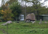
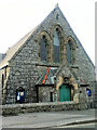
Pastscape says - "Early Christian memorial stone in St Francis churchyard, Indian Queens. The memorial stone survives as an upright granite shaft measuring 1.65 metres in overall height. It is rectangular in section with the broader faces oriented north-south. This stone bears an incised inscription in one line running down its north face. The inscription is in Latin, and has been read as `RVANI HIC IACIT', or `MAGLI HIC'. The inscription is very worn and virtually indecipherable. The use of an upright shaft or stone with a simple Latin inscription suggests a fifth/sixth century to eleventh century date for this memorial stone. Also on the north face are two holes, the lower is filled with lead with the remains of an iron gate fitting in it. Both these holes indicate that the stone was used as a gatepost sometime in the past. It was first recorded by the antiquarian, Borlase in 1754 as "about four miles east of Michel". By 1872 the stone had been moved to the Indian Queens Inn, where the historian, Henderson stated it had marked the parish boundary between St Enoder and St Columb. A road widening scheme caused it to be moved to its present location in 1939. Scheduled".
You may be viewing yesterday's version of this page. To see the most up to date information please register for a free account.
")
Do not use the above information on other web sites or publications without permission of the contributor.
Nearby Images from Geograph Britain and Ireland:
©2006(licence)
©2006(licence)
©2009(licence)

©2023(licence)
©2023(licence)
The above images may not be of the site on this page, they are loaded from Geograph.
Please Submit an Image of this site or go out and take one for us!
Click here to see more info for this site
Nearby sites
Key: Red: member's photo, Blue: 3rd party photo, Yellow: other image, Green: no photo - please go there and take one, Grey: site destroyed
Download sites to:
KML (Google Earth)
GPX (GPS waypoints)
CSV (Garmin/Navman)
CSV (Excel)
To unlock full downloads you need to sign up as a Contributory Member. Otherwise downloads are limited to 50 sites.
Turn off the page maps and other distractions
Nearby sites listing. In the following links * = Image available
1.7km NNE 28° St Columba Holy Well* Holy Well or Sacred Spring (SW925606)
2.9km NNE 12° Devil's Quoit (St Columb Major)* Burial Chamber or Dolmen (SW9234161952)
3.1km ENE 57° Deep Tye Farm Henge (SW943607)
3.3km SW 225° St Enoder Cross* Ancient Cross (SW892569)
3.6km E 101° St Dennis Hill Fort* Hillfort (SW951583)
3.6km E 100° St Dennis Churchyard Cross* Ancient Cross (SW95155835)
4.4km NE 40° Castle an Dinas (St Columb)* Hillfort (SW94556236)
4.8km WNW 283° Our Lady of Nance* Holy Well or Sacred Spring (SW870604)
5.6km WSW 256° Dairyland Farm World* Modern Stone Circle etc (SW861580)
6.3km SE 135° St Stephens Beacon* Hillfort (SW959545)
6.3km NE 34° St. Wenna's well* Holy Well or Sacred Spring (SW954642)
6.5km NE 56° Belowda Beacon tumuli* Barrow Cemetery (SW97136254)
6.6km WNW 296° St. Pedyr's Well* Holy Well or Sacred Spring (SW8579462245)
7.1km E 80° Menevegar Menhir* Standing Stone (Menhir) (SW98676011)
7.2km E 82° Roche Cross* Ancient Cross (SW98795978)
7.3km ENE 67° St Gundred's Well* Holy Well or Sacred Spring (SW985617)
7.4km ESE 110° Cocksbarrow Timber Circle (SW985563)
7.4km WNW 290° Rialton Manor* Holy Well or Sacred Spring (SW847619)
7.5km E 84° Roche Rock* Rock Outcrop (SW99105962)
7.5km NE 51° Demelza Castle* Ancient Village or Settlement (SW977636)
7.6km SSW 192° Fentonladock* Holy Well or Sacred Spring (SW8978851719)
7.6km NW 321° St James's Well, Ball* Holy Well or Sacred Spring (SW8709865269)
8.0km SE 140° Langerth Round* Ancient Village or Settlement (SW96515277)
8.1km NW 325° St Mawgan's Holy Well* Holy Well or Sacred Spring (SW87276592)
8.1km NW 325° Mawgan Cross* Ancient Cross (SW87256594)
View more nearby sites and additional images


 We would like to know more about this location. Please feel free to add a brief description and any relevant information in your own language.
 Wir möchten mehr über diese Stätte erfahren. Bitte zögern Sie nicht, eine kurze Beschreibung und relevante Informationen in Deutsch hinzuzufügen.
 Nous aimerions en savoir encore un peu sur les lieux. S'il vous plaît n'hesitez pas à ajouter une courte description et tous les renseignements pertinents dans votre propre langue.
 Quisieramos informarnos un poco más de las lugares. No dude en añadir una breve descripción y otros datos relevantes en su propio idioma.