


<< Text Pages >> Knockrivoch Mount - Barrow Cemetery in Scotland in North Ayrshire
Submitted by AstroGeologist on Sunday, 19 May 2019 Page Views: 747
Neolithic and Bronze AgeSite Name: Knockrivoch Mount Alternative Name: Knockrivoch Barrow, Knockrivoch TumulusCountry: Scotland
NOTE: This site is 0.327 km away from the location you searched for.
County: North Ayrshire Type: Barrow Cemetery
Nearest Town: Saltcoats Nearest Village: Seamill
Map Ref: NS25344510
Latitude: 55.667898N Longitude: 4.778596W
Condition:
| 5 | Perfect |
| 4 | Almost Perfect |
| 3 | Reasonable but with some damage |
| 2 | Ruined but still recognisable as an ancient site |
| 1 | Pretty much destroyed, possibly visible as crop marks |
| 0 | No data. |
| -1 | Completely destroyed |
| 5 | Superb |
| 4 | Good |
| 3 | Ordinary |
| 2 | Not Good |
| 1 | Awful |
| 0 | No data. |
| 5 | Can be driven to, probably with disabled access |
| 4 | Short walk on a footpath |
| 3 | Requiring a bit more of a walk |
| 2 | A long walk |
| 1 | In the middle of nowhere, a nightmare to find |
| 0 | No data. |
| 5 | co-ordinates taken by GPS or official recorded co-ordinates |
| 4 | co-ordinates scaled from a detailed map |
| 3 | co-ordinates scaled from a bad map |
| 2 | co-ordinates of the nearest village |
| 1 | co-ordinates of the nearest town |
| 0 | no data |
Internal Links:
External Links:
Barrow Cemetery in North Ayrshire
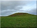
Thought to have been a Motte for nearly a century, Knockrivoch Mount is now thought by archaeologist's to be a Tumulus (Bearing resemblance to a Tumulus discovered 5.5km away in Dalry)
Situated 140m above sea level on the summit of a low ridge with a commanding view in all directions, it provides a great view of Goat Fell on Arran 26.5km away to the West.
First documented in 1856, "John Smith" measured the site in 1895 as being 3.6m high, with the flat top measuring about 16m x 9m. He noted that part of the Tumulus had been removed. Sixty years later when OS visited, the flat top of the summit was down in size to 9.5m x 6m, with an overall site dimension of 30m E-W x 21m, and a berm 5m wide around the base of the Barrow.
A subsequent visit by OS in 1982 describe the remains as being oval in shape, 30m x 24m and 3.3m high, but may possibly once have been circular, with a 30m diameter.
They note the berm that is now mostly evident on the South and West sides, may be significant in that it could represent either a general levelling of the area prior to construction, or a scrape zone for the mound material.
For more information : Canmore ID 40971
You may be viewing yesterday's version of this page. To see the most up to date information please register for a free account.
Do not use the above information on other web sites or publications without permission of the contributor.
Nearby Images from Geograph Britain and Ireland:
©2016(licence)
©2006(licence)
©2006(licence)
©2016(licence)
©2016(licence)
The above images may not be of the site on this page, they are loaded from Geograph.
Please Submit an Image of this site or go out and take one for us!
Click here to see more info for this site
Nearby sites
Key: Red: member's photo, Blue: 3rd party photo, Yellow: other image, Green: no photo - please go there and take one, Grey: site destroyed
Download sites to:
KML (Google Earth)
GPX (GPS waypoints)
CSV (Garmin/Navman)
CSV (Excel)
To unlock full downloads you need to sign up as a Contributory Member. Otherwise downloads are limited to 50 sites.
Turn off the page maps and other distractions
Nearby sites listing. In the following links * = Image available
1.3km SE 125° Diddup Hillfort Hillfort (NS2636344331)
1.9km NNW 348° Blackshaw Moor Stone Circle (NS250470)
2.4km ESE 107° Ashgrove Loch Crannog* Crannog (NS27594431)
3.6km SSE 149° Stevenston Souterrain Souterrain (Fogou, Earth House) (NS27114193)
3.7km SW 215° Ardrossan Shell Mound* Artificial Mound (NS23134218)
3.9km NW 323° Blackshaw Rock Art* Rock Art (NS23104834)
3.9km SE 138° Dubbs Cist Cist (NS27884208)
5.0km SE 125° Todhill Crannog Crannog (NS2930042101)
5.4km WNW 290° Seamill Fort* Promontory Fort / Cliff Castle (NS20314715)
5.7km SE 143° Ardeer Sands Ancient Village or Settlement (NS2857740455)
5.9km NE 39° Courthill Cairn* Round Barrow(s) (NS29244958)
6.0km ESE 115° Dirrans burial* Cist (NS30684230)
6.3km NNW 337° Little Caldron Cairn Cairn (NS23155100)
6.5km NNW 336° Caldron Cairn Cairn (NS22905115)
6.8km ENE 68° Cleaves Cove* Cave or Rock Shelter (NS31774744)
7.5km NNW 326° Glentane Standing Stones Standing Stones (NS21445152)
7.5km ESE 110° Eglinton Park Ancient Village or Settlement (NS3229642217)
8.0km NW 326° Biglees Cairn Cairn (NS21125196)
8.4km NNE 21° Carwinning Hill Hillfort (NS28715286)
8.5km WNW 296° Auld Hill Fort (Portencross) Hillfort (NS17834910)
8.7km NNW 340° Kaim Hill Cairn Cairn (NS22715342)
9.2km SE 132° Grannie Stane* Natural Stone / Erratic / Other Natural Feature (NS3196038711)
9.3km NW 305° Hawking Craig Cave or Rock Shelter (NS17945079)
9.3km ESE 110° Sourlie Hill Modern Stone Circle etc (NS3398041490)
9.3km NNW 332° Southannan 2 Rock Art (NS21205350)
View more nearby sites and additional images


 We would like to know more about this location. Please feel free to add a brief description and any relevant information in your own language.
 Wir möchten mehr über diese Stätte erfahren. Bitte zögern Sie nicht, eine kurze Beschreibung und relevante Informationen in Deutsch hinzuzufügen.
 Nous aimerions en savoir encore un peu sur les lieux. S'il vous plaît n'hesitez pas à ajouter une courte description et tous les renseignements pertinents dans votre propre langue.
 Quisieramos informarnos un poco más de las lugares. No dude en añadir una breve descripción y otros datos relevantes en su propio idioma.