


<< Text Pages >> Cardigan Eisteddfod Commemorative Stone - Modern Stone Circle etc in Wales in Ceredigion
Submitted by AngieLake on Monday, 10 November 2008 Page Views: 6722
Modern SitesSite Name: Cardigan Eisteddfod Commemorative StoneCountry: Wales
NOTE: This site is 0.483 km away from the location you searched for.
County: Ceredigion Type: Modern Stone Circle etc
Nearest Town: Cardigan
Map Ref: SN1774645894
Latitude: 52.081321N Longitude: 4.661199W
Condition:
| 5 | Perfect |
| 4 | Almost Perfect |
| 3 | Reasonable but with some damage |
| 2 | Ruined but still recognisable as an ancient site |
| 1 | Pretty much destroyed, possibly visible as crop marks |
| 0 | No data. |
| -1 | Completely destroyed |
| 5 | Superb |
| 4 | Good |
| 3 | Ordinary |
| 2 | Not Good |
| 1 | Awful |
| 0 | No data. |
| 5 | Can be driven to, probably with disabled access |
| 4 | Short walk on a footpath |
| 3 | Requiring a bit more of a walk |
| 2 | A long walk |
| 1 | In the middle of nowhere, a nightmare to find |
| 0 | No data. |
| 5 | co-ordinates taken by GPS or official recorded co-ordinates |
| 4 | co-ordinates scaled from a detailed map |
| 3 | co-ordinates scaled from a bad map |
| 2 | co-ordinates of the nearest village |
| 1 | co-ordinates of the nearest town |
| 0 | no data |
Internal Links:
External Links:
I have visited· I would like to visit
AngieLake has visited here
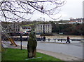
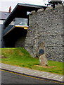
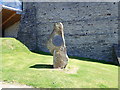
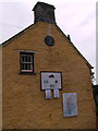
An impressive modern standing stone (origin uncertain - could be ancient?) with modern sculpted slate plaque commemorating the very first Welsh Eisteddfod, which took place within Cardigan Castle, nearby.
It stands on the right of the road in Bridge Street, Cardigan, on grass next to the castle walls, as one enters the town across the old bridge.
The inscription reads:
"Here in 1176 the tradition of the Welsh Eisteddfod began in Cardigan Castle. A grand feast of music and poetry was sponsored and hosted by the Lord Rhys, a generous patron of The Arts."
(I'd include the Welsh text too, if I could decipher all the letters. Hopefully they will be readable in the photo.)
The stone was unveiled in 1993, and more information can be found on http://pmsa.cch.kcl.ac.uk/AH/CERED013.htm.
You may be viewing yesterday's version of this page. To see the most up to date information please register for a free account.
")
")
")
Do not use the above information on other web sites or publications without permission of the contributor.
Nearby Images from Geograph Britain and Ireland:
©2010(licence)
©2015(licence)
©2019(licence)
©2019(licence)
©2012(licence)
The above images may not be of the site on this page, they are loaded from Geograph.
Please Submit an Image of this site or go out and take one for us!
Click here to see more info for this site
Nearby sites
Key: Red: member's photo, Blue: 3rd party photo, Yellow: other image, Green: no photo - please go there and take one, Grey: site destroyed
Download sites to:
KML (Google Earth)
GPX (GPS waypoints)
CSV (Garmin/Navman)
CSV (Excel)
To unlock full downloads you need to sign up as a Contributory Member. Otherwise downloads are limited to 50 sites.
Turn off the page maps and other distractions
Nearby sites listing. In the following links * = Image available
1.3km W 269° St Dogmael's Church* Early Christian Sculptured Stone (SN1640745909)
1.4km W 281° Blessingstone* Natural Stone / Erratic / Other Natural Feature (SN164462)
3.1km ENE 57° Banc-y-Warren Hillfort (SN20414750)
3.1km SSE 153° Cilgerran Churchyard* Standing Stone (Menhir) (SN19074306)
3.3km NW 308° Manian Fach Tumulus Round Barrow(s) (SN152480)
3.5km N 350° Towyn Warren Ancient Village or Settlement (SN17294932)
3.6km SSE 150° Cilgerran stone* Standing Stone (Menhir) (SN1945942671)
3.8km ENE 75° Pant y Butler round barrows* Round Barrow(s) (SN21464672)
3.8km S 180° Bridell Churchyard* Standing Stone (Menhir) (SN176421)
4.6km NE 54° Llech Yr Ast Standing Stone (Menhir) (SN216485)
4.7km WNW 292° Cippyn Burnt Mounds Artificial Mound (SN134478)
5.1km N 359° Crug Farm Tumulus Round Barrow(s) (SN178510)
5.2km SSW 197° Y Gaer (Pembrokeshire) Hillfort (SN16024097)
6.3km NNE 12° Foel y Mwnt* Promontory Fort / Cliff Castle (SN193520)
6.3km S 190° Parc y Mean Llwyd Standing Stone (Menhir) (SN164397)
6.5km SSW 197° Bwlch Garreg-Llwyd Standing Stone (Menhir) (SN15613972)
6.7km WSW 242° Trefaes Ganol Standing Stone Standing Stone (Menhir) (SN1167042952)
6.8km SW 228° Crugiau Cemaes* Barrow Cemetery (SN125415)
6.9km SSE 165° Mynydd Crogwy Standing Stone (Menhir) (SN19323916)
6.9km S 181° Saint Meugans Well Holy Well or Sacred Spring (SN17403897)
7.7km S 185° Castell Coch (Pembrokeshire) Hillfort (SN16783824)
7.8km SW 235° Caer Bayvil* Hillfort (SN112417)
7.9km WSW 240° Tumulus at Pantygroes farm* Round Barrow(s) (SN107422)
8.1km WSW 248° Llech Y Dribedd* Chambered Tomb (SN10054319)
8.4km SSW 205° Ffynnon Fair (Pembrokeshire) Holy Well or Sacred Spring (SN13953843)
View more nearby sites and additional images


 We would like to know more about this location. Please feel free to add a brief description and any relevant information in your own language.
 Wir möchten mehr über diese Stätte erfahren. Bitte zögern Sie nicht, eine kurze Beschreibung und relevante Informationen in Deutsch hinzuzufügen.
 Nous aimerions en savoir encore un peu sur les lieux. S'il vous plaît n'hesitez pas à ajouter une courte description et tous les renseignements pertinents dans votre propre langue.
 Quisieramos informarnos un poco más de las lugares. No dude en añadir una breve descripción y otros datos relevantes en su propio idioma.