

<< Our Photo Pages >> Caer Gybi Roman Fort - Stone Fort or Dun in Wales in Anglesey
Submitted by w650marion on Thursday, 06 May 2021 Page Views: 1032
Roman, Greek and ClassicalSite Name: Caer Gybi Roman FortCountry: Wales
NOTE: This site is 0.376 km away from the location you searched for.
County: Anglesey Type: Stone Fort or Dun
Nearest Town: Holyhead
Map Ref: SH2471882615
Latitude: 53.311381N Longitude: 4.632461W
Condition:
| 5 | Perfect |
| 4 | Almost Perfect |
| 3 | Reasonable but with some damage |
| 2 | Ruined but still recognisable as an ancient site |
| 1 | Pretty much destroyed, possibly visible as crop marks |
| 0 | No data. |
| -1 | Completely destroyed |
| 5 | Superb |
| 4 | Good |
| 3 | Ordinary |
| 2 | Not Good |
| 1 | Awful |
| 0 | No data. |
| 5 | Can be driven to, probably with disabled access |
| 4 | Short walk on a footpath |
| 3 | Requiring a bit more of a walk |
| 2 | A long walk |
| 1 | In the middle of nowhere, a nightmare to find |
| 0 | No data. |
| 5 | co-ordinates taken by GPS or official recorded co-ordinates |
| 4 | co-ordinates scaled from a detailed map |
| 3 | co-ordinates scaled from a bad map |
| 2 | co-ordinates of the nearest village |
| 1 | co-ordinates of the nearest town |
| 0 | no data |
Internal Links:
External Links:
I have visited· I would like to visit
elad13 visited on 20th May 2023 - their rating: Cond: 3 Amb: 4 Access: 4
Klingon visited on 29th Oct 2022 - their rating: Cond: 3 Amb: 3 Access: 5
Average ratings for this site from all visit loggers: Condition: 3 Ambience: 3.5 Access: 4.5
")
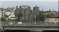
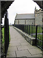
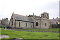
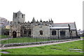
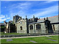
The walls and towers of this third century Roman Fort are still standing and in use surrounding St. Cybi's medieval church. The walls (with distinctive herringbone stonework) are extremely well-preserved, standing up to 13ft/4m high and 5ft/1.5m thick. You can also see remains of four corner towers. Occupying a vantage point above the harbour, the 26ft north-east tower is the most prominent, though the top section is a later rebuild possibly dating to the medieval period.
Coflein Reference
Gwynedd Archaeological Trust record
You may be viewing yesterday's version of this page. To see the most up to date information please register for a free account.
")
")
")
Do not use the above information on other web sites or publications without permission of the contributor.
Nearby Images from Geograph Britain and Ireland:
©2009(licence)
©2011(licence)
©2016(licence)
©2016(licence)
©2023(licence)
The above images may not be of the site on this page, they are loaded from Geograph.
Please Submit an Image of this site or go out and take one for us!
Click here to see more info for this site
Nearby sites
Key: Red: member's photo, Blue: 3rd party photo, Yellow: other image, Green: no photo - please go there and take one, Grey: site destroyed
Download sites to:
KML (Google Earth)
GPX (GPS waypoints)
CSV (Garmin/Navman)
CSV (Excel)
To unlock full downloads you need to sign up as a Contributory Member. Otherwise downloads are limited to 50 sites.
Turn off the page maps and other distractions
Nearby sites listing. In the following links * = Image available
1.8km NW 310° Stones near Holyhead breakwater* Natural Stone / Erratic / Other Natural Feature (SH2340583806)
1.8km SSE 156° Ty Mawr (Nr Holyhead)* Standing Stone (Menhir) (SH2539480951)
1.9km SSW 203° Carreg y Bwgan* Natural Stone / Erratic / Other Natural Feature (SH2390380891)
2.2km WSW 242° Gorsedd Gwlwm* Chambered Cairn (SH2275681655)
2.2km ESE 108° Penrhos (Holyhead)* Standing Stone (Menhir) (SH26828183)
2.3km SSE 149° Trefignath* Chambered Tomb (SH25858056)
2.4km W 259° Ffynnon y Wrach* Holy Well or Sacred Spring (SH22328226)
2.6km SW 228° Penrhos-Feilw* Standing Stones (SH22708094)
2.8km SSW 205° Porth Dafarch ancient huts* Ancient Village or Settlement (SH234801)
2.9km W 275° Caer y Twr* Hillfort (SH218830)
2.9km SE 143° Trearddur Dolmen* Burial Chamber or Dolmen (SH264802)
3.2km WSW 258° Maen Bras* Natural Stone / Erratic / Other Natural Feature (SH21608210)
3.3km W 270° Garn Cairn (Holyhead)* Ring Cairn (SH21408276)
3.4km WSW 237° South Stack Stone Pile* Natural Stone / Erratic / Other Natural Feature (SH2177880876)
3.5km SSW 213° Porthyrhwydau* Cave or Rock Shelter (SH227797)
3.6km WSW 258° Holyhead Mountain* Ancient Village or Settlement (SH21128196)
4.0km SW 215° Fort Dinas, Porth Ruffydd* Promontory Fort / Cliff Castle (SH22277941)
4.3km SSE 150° Trearddur standing stone* Standing Stone (Menhir) (SH267788)
4.7km SE 140° Ynys Leurad* Ancient Village or Settlement (SH2764978895)
6.2km SSE 163° Cromlech in Rhoscolyn* Burial Chamber or Dolmen (SH2634376610)
6.3km SSE 150° Bodior Standing Stone* Standing Stone (Menhir) (SH277770)
6.5km SSE 167° Bwa Gwyn* Natural Stone / Erratic / Other Natural Feature (SH259762)
7.2km E 99° Shop Farm* Standing Stone (Menhir) (SH3180581223)
7.3km SSE 168° St Gwenfaens Well* Holy Well or Sacred Spring (SH2594975436)
7.8km SSE 160° Borthwen Beach* Chambered Tomb (SH2714975151)
View more nearby sites and additional images


 We would like to know more about this location. Please feel free to add a brief description and any relevant information in your own language.
 Wir möchten mehr über diese Stätte erfahren. Bitte zögern Sie nicht, eine kurze Beschreibung und relevante Informationen in Deutsch hinzuzufügen.
 Nous aimerions en savoir encore un peu sur les lieux. S'il vous plaît n'hesitez pas à ajouter une courte description et tous les renseignements pertinents dans votre propre langue.
 Quisieramos informarnos un poco más de las lugares. No dude en añadir una breve descripción y otros datos relevantes en su propio idioma.