

<< Our Photo Pages >> Crug Bach - Round Barrow(s) in Wales in Carmarthenshire
Submitted by coldrum on Monday, 19 January 2009 Page Views: 3452
Neolithic and Bronze AgeSite Name: Crug Bach Alternative Name: Crug-BachCountry: Wales
NOTE: This site is 1.211 km away from the location you searched for.
County: Carmarthenshire Type: Round Barrow(s)
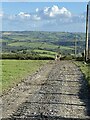
Nearest Town: Rhos
Map Ref: SN39603147
Latitude: 51.958515N Longitude: 4.335809W
Condition:
| 5 | Perfect |
| 4 | Almost Perfect |
| 3 | Reasonable but with some damage |
| 2 | Ruined but still recognisable as an ancient site |
| 1 | Pretty much destroyed, possibly visible as crop marks |
| 0 | No data. |
| -1 | Completely destroyed |
| 5 | Superb |
| 4 | Good |
| 3 | Ordinary |
| 2 | Not Good |
| 1 | Awful |
| 0 | No data. |
| 5 | Can be driven to, probably with disabled access |
| 4 | Short walk on a footpath |
| 3 | Requiring a bit more of a walk |
| 2 | A long walk |
| 1 | In the middle of nowhere, a nightmare to find |
| 0 | No data. |
| 5 | co-ordinates taken by GPS or official recorded co-ordinates |
| 4 | co-ordinates scaled from a detailed map |
| 3 | co-ordinates scaled from a bad map |
| 2 | co-ordinates of the nearest village |
| 1 | co-ordinates of the nearest town |
| 0 | no data |
Be the first person to rate this site - see the 'Contribute!' box in the right hand menu.
Internal Links:
External Links:
")
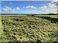
29m diameter circular mound.
Coflein site no. 303752.
You may be viewing yesterday's version of this page. To see the most up to date information please register for a free account.
Do not use the above information on other web sites or publications without permission of the contributor.
coldrum has found this location on Google Street View:
Nearby Images from Geograph Britain and Ireland:
©2008(licence)
©2021(licence)
©2015(licence)
©2021(licence)
©2021(licence)
The above images may not be of the site on this page, they are loaded from Geograph.
Please Submit an Image of this site or go out and take one for us!
Click here to see more info for this site
Nearby sites
Key: Red: member's photo, Blue: 3rd party photo, Yellow: other image, Green: no photo - please go there and take one, Grey: site destroyed
Download sites to:
KML (Google Earth)
GPX (GPS waypoints)
CSV (Garmin/Navman)
CSV (Excel)
To unlock full downloads you need to sign up as a Contributory Member. Otherwise downloads are limited to 50 sites.
Turn off the page maps and other distractions
Nearby sites listing. In the following links * = Image available
731m NE 37° Crug Gwyn* Cairn (SN40063204)
1.5km NE 35° Crugiau Fach* Barrow Cemetery (SN40543270)
1.9km NE 36° Crug Gilfach Fach Round Barrow(s) (SN40783299)
2.1km NNW 345° Crug-Glas Round Barrow(s) (SN39113349)
2.2km N 353° Crug-Bach Barrow (Rhos) Round Barrow(s) (SN39393363)
2.4km NNE 23° Gareg Hir* Standing Stone (Menhir) (SN40603367)
2.5km WNW 295° Cerrig Llwydion (Carms)* Chambered Tomb (SN374326)
2.5km N 5° Carn-Wen Round Barrow(s) (SN39903397)
2.5km N 5° Carreg Wen Standing Stone Standing Stone (Menhir) (SN399340)
2.6km NW 314° Clawdd Mawr* Misc. Earthwork (SN37743335)
3.6km SSE 149° Ffosymaen* Standing Stone (Menhir) (SN414283)
4.7km NNE 17° Blaennantrhys Cairn 3* Cairn (SN41123592)
4.8km NNE 14° Blaennantrhys Cairn 1* Cairn (SN40933607)
4.8km NNE 14° Blaennantrhys Cairn 2 Ring Cairn (SN40943607)
4.8km NNE 15° Cross Hands (Hebron)* Standing Stone (Menhir) (SN410361)
4.8km NNE 19° Yr Hen Llech Chambered Tomb (SN413360)
5.1km NW 305° Ty-Mathiau Stone Row / Alignment (SN35483452)
5.5km SSE 150° Bryncennau standing stone* Standing Stone (Menhir) (SN42192662)
5.8km NE 34° Crug Sgethlin* Cairn (SN43033616)
6.4km N 2° Aelybryn* Standing Stone (Menhir) (SN40053785)
7.2km N 3° Ffynnon Fair (Carmarthenshire) Holy Well or Sacred Spring (SN40263864)
7.3km S 178° Crugiau Garn Fawr* Barrow Cemetery (SN39682419)
7.3km E 81° Eirth dant* Standing Stone (Menhir) (SN469324)
7.4km S 178° Crug Tumuli* Round Barrow(s) (SN396241)
7.4km SSE 152° Cwmhawddgar Standing Stone* Standing Stone (Menhir) (SN4288124790)
View more nearby sites and additional images


 We would like to know more about this location. Please feel free to add a brief description and any relevant information in your own language.
 Wir möchten mehr über diese Stätte erfahren. Bitte zögern Sie nicht, eine kurze Beschreibung und relevante Informationen in Deutsch hinzuzufügen.
 Nous aimerions en savoir encore un peu sur les lieux. S'il vous plaît n'hesitez pas à ajouter une courte description et tous les renseignements pertinents dans votre propre langue.
 Quisieramos informarnos un poco más de las lugares. No dude en añadir una breve descripción y otros datos relevantes en su propio idioma.