

<< Our Photo Pages >> Craighead Cairn - Cairn in Scotland in Stirling
Submitted by cosmic on Monday, 16 January 2006 Page Views: 5412
Neolithic and Bronze AgeSite Name: Craighead CairnCountry: Scotland
NOTE: This site is 3.06 km away from the location you searched for.
County: Stirling Type: Cairn
Nearest Town: Stirling
Map Ref: NS69039822
Latitude: 56.158607N Longitude: 4.11031W
Condition:
| 5 | Perfect |
| 4 | Almost Perfect |
| 3 | Reasonable but with some damage |
| 2 | Ruined but still recognisable as an ancient site |
| 1 | Pretty much destroyed, possibly visible as crop marks |
| 0 | No data. |
| -1 | Completely destroyed |
| 5 | Superb |
| 4 | Good |
| 3 | Ordinary |
| 2 | Not Good |
| 1 | Awful |
| 0 | No data. |
| 5 | Can be driven to, probably with disabled access |
| 4 | Short walk on a footpath |
| 3 | Requiring a bit more of a walk |
| 2 | A long walk |
| 1 | In the middle of nowhere, a nightmare to find |
| 0 | No data. |
| 5 | co-ordinates taken by GPS or official recorded co-ordinates |
| 4 | co-ordinates scaled from a detailed map |
| 3 | co-ordinates scaled from a bad map |
| 2 | co-ordinates of the nearest village |
| 1 | co-ordinates of the nearest town |
| 0 | no data |
Internal Links:
External Links:
")
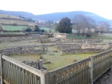
A former earthen mound was surrounded by the dry stone wll within which were planted some trees in the mid C-18th. When dug into c.1758 when it was found "full of urns, some with inscriptions, not legible".
For more information see Canmore ID 45355 which tells us that the cairn measures 14m in diameters and is 1.5m in height.
You may be viewing yesterday's version of this page. To see the most up to date information please register for a free account.
")
")
")
Do not use the above information on other web sites or publications without permission of the contributor.
Nearby Images from Geograph Britain and Ireland:
©2008(licence)
©2006(licence)
©2007(licence)
©2008(licence)
©2007(licence)
The above images may not be of the site on this page, they are loaded from Geograph.
Please Submit an Image of this site or go out and take one for us!
Click here to see more info for this site
Nearby sites
Key: Red: member's photo, Blue: 3rd party photo, Yellow: other image, Green: no photo - please go there and take one, Grey: site destroyed
Download sites to:
KML (Google Earth)
GPX (GPS waypoints)
CSV (Garmin/Navman)
CSV (Excel)
To unlock full downloads you need to sign up as a Contributory Member. Otherwise downloads are limited to 50 sites.
Turn off the page maps and other distractions
Nearby sites listing. In the following links * = Image available
614m E 97° Coldoch Broch* Broch or Nuraghe (NS6963998128)
3.6km ENE 75° Old Farm (Blair Drummond) Cairn (NS72539906)
3.9km ENE 78° Christ's Well (Blair Drummond) Holy Well or Sacred Spring (NS7291998903)
4.0km NE 41° Tulloch Knowe (Doune)s Cairn (NN7178201194)
4.2km S 175° Leckie Broch* Broch or Nuraghe (NS6925494002)
4.2km S 175° Leckie 2* Rock Art (NS69269399)
4.2km S 175° Leckie 1* Rock Art (NS6925993985)
5.0km NE 42° Trysting Stone* Standing Stone (Menhir) (NN72550185)
6.8km ENE 69° Doune (Glenhead)* Stone Row / Alignment (NN7549300457)
7.0km ENE 65° Glenhead Standing Stone (Doune)* Standing Stone (Menhir) (NN75520100)
7.4km SE 138° St Corbet's Well (Touch) Holy Well or Sacred Spring (NS738925)
7.5km WNW 289° The Ruskie Stane* Modern Stone Circle etc (NN6203800912)
7.5km NNW 329° Wester Torrie Stone Circle (NN65340480)
8.1km NNW 333° Ballochallan* Modern Stone Circle etc (NN65580559)
8.3km NNW 330° St Mary's Well (Callender)* Holy Well or Sacred Spring (NN65070556)
8.3km N 352° Ballachraggan Chambered Cairn (NN68050650)
8.9km NNE 32° The Judge's Cairn (Dunblane) Cairn (NN7394405618)
9.5km SE 139° Castlehill Wood Dun* Stone Fort or Dun (NS75089090)
9.6km ENE 75° Kippenross House (Dunblane) Cairn (NN78370036)
9.6km ENE 69° Dunblane Cathedral* Class III Pictish Cross Slab (NN78170139)
9.7km ENE 69° Dunblane Museum* Museum (NN7819301343)
9.8km NNW 334° Auchenlaich Cairn* Chambered Cairn (NN64980715)
10.1km SE 128° Gillies Hill* Hillfort (NS76879176)
10.1km SSE 151° King's Yett (St Ninian's) Cairn (NS73738922)
10.2km ESE 119° St Thomas's Well (Cambusbarron)* Holy Well or Sacred Spring (NS7788493056)
View more nearby sites and additional images


 We would like to know more about this location. Please feel free to add a brief description and any relevant information in your own language.
 Wir möchten mehr über diese Stätte erfahren. Bitte zögern Sie nicht, eine kurze Beschreibung und relevante Informationen in Deutsch hinzuzufügen.
 Nous aimerions en savoir encore un peu sur les lieux. S'il vous plaît n'hesitez pas à ajouter une courte description et tous les renseignements pertinents dans votre propre langue.
 Quisieramos informarnos un poco más de las lugares. No dude en añadir una breve descripción y otros datos relevantes en su propio idioma.