

<< Our Photo Pages >> Parc Y Borth Enclosed Hut Circle Settlement - Ancient Village or Settlement in Wales in Gwynedd
Submitted by TAlanJones on Thursday, 03 February 2022 Page Views: 541
Multi-periodSite Name: Parc Y Borth Enclosed Hut Circle SettlementCountry: Wales
NOTE: This site is 1.116 km away from the location you searched for.
County: Gwynedd Type: Ancient Village or Settlement
Nearest Town: Porthmadog Nearest Village: Borth y Gest
Map Ref: SH562378
Latitude: 52.918314N Longitude: 4.140223W
Condition:
| 5 | Perfect |
| 4 | Almost Perfect |
| 3 | Reasonable but with some damage |
| 2 | Ruined but still recognisable as an ancient site |
| 1 | Pretty much destroyed, possibly visible as crop marks |
| 0 | No data. |
| -1 | Completely destroyed |
| 5 | Superb |
| 4 | Good |
| 3 | Ordinary |
| 2 | Not Good |
| 1 | Awful |
| 0 | No data. |
| 5 | Can be driven to, probably with disabled access |
| 4 | Short walk on a footpath |
| 3 | Requiring a bit more of a walk |
| 2 | A long walk |
| 1 | In the middle of nowhere, a nightmare to find |
| 0 | No data. |
| 5 | co-ordinates taken by GPS or official recorded co-ordinates |
| 4 | co-ordinates scaled from a detailed map |
| 3 | co-ordinates scaled from a bad map |
| 2 | co-ordinates of the nearest village |
| 1 | co-ordinates of the nearest town |
| 0 | no data |
Internal Links:
External Links:
")
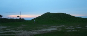
Situated within a forest park just north of Borth y Gest village the site can be accessed via a footpath ascending from the village's sea front. The site comprises the remains of a small compact settlement of three circular structures set within a sub oval enclosure. The site has been dated to the Iron Age from finds discovered during excavations in the past. It is also a scheduled monument.
Two of the hut circles have an interior diameter of 7m whilst the third appears to be about 4m (see photo of artist impression). The huts appear to have been at differing floor levels with terraces linking them within the enclosure. The interior of the huts are depressed, useful in defining the shape of the huts given the lack of any significant raised walling.
The site is quite rare given its survival located close to the sea in a lowland environment.
You may be viewing yesterday's version of this page. To see the most up to date information please register for a free account.
")
")
")
")
")
")
")
Do not use the above information on other web sites or publications without permission of the contributor.
Click here to see more info for this site
Nearby sites
Key: Red: member's photo, Blue: 3rd party photo, Yellow: other image, Green: no photo - please go there and take one, Grey: site destroyed
Download sites to:
KML (Google Earth)
GPX (GPS waypoints)
CSV (Garmin/Navman)
CSV (Excel)
To unlock full downloads you need to sign up as a Contributory Member. Otherwise downloads are limited to 50 sites.
Turn off the page maps and other distractions
Nearby sites listing. In the following links * = Image available
1.6km NW 321° Hut Circle North of Moel Y Gest* Ancient Village or Settlement (SH552391)
1.7km WNW 287° Hut Circle East of Cist Gerrig* Ancient Village or Settlement (SH5460038330)
1.7km NW 309° Moel Y Gest Hillfort* Hillfort (SH549389)
1.8km WNW 302° Hut Circle West of Moel Y Gest Ancient Village or Settlement (SH547388)
1.9km N 10° Porthmadog Eisteddfod Stone Circle* Modern Stone Circle etc (SH56583966)
2.0km WNW 286° Cist Cerrig* Portal Tomb (SH54333841)
2.1km WNW 284° Enclosed Hut Group near Ty Mawr* Ancient Village or Settlement (SH5413038370)
2.7km W 269° The Treflys Stone* Sculptured Stone (SH53453785)
3.2km NNW 338° Hut circles west of Allt Wen* Ancient Village or Settlement (SH551408)
3.4km N 9° Fach Goch* Standing Stone (Menhir) (SH56844115)
3.6km NNW 335° Cairns east of Graig Y Gesail* Cairn (SH548411)
3.7km NNW 344° Cwm Mawr Stone Circle (SH553414)
3.7km NNW 338° Hut Group West of Cwm Mawr Ancient Village or Settlement (SH549413)
3.8km NNW 338° Cwm Mawr Hut Group Ancient Village or Settlement (SH54904135)
3.8km NNW 335° Hut Circle near Graig Y Gesail* Ancient Village or Settlement (SH547413)
4.0km N 7° Hendre Seler Hut Circle* Ancient Village or Settlement (SH5680041730)
4.0km WNW 296° Trefllys* Standing Stone (Menhir) (SH52663968)
4.1km ENE 67° Ty'n Y Berllan Enclosed Hut Circle Settlement* Ancient Village or Settlement (SH600393)
4.5km NNW 347° Cerrig Cae-glan-yr-afon* Marker Stone (SH55324220)
4.7km NNW 343° Cae Glan Yr Afon Stone Feature* Modern Stone Circle etc (SH5498142368)
4.8km N 3° Llyn Du Hut Circle 2* Ancient Village or Settlement (SH5657342584)
4.8km N 3° Llyn Du Hut Circle 1* Ancient Village or Settlement (SH5656842599)
5.0km N 2° Cae'r Eithin Tew Hut Circle* Ancient Village or Settlement (SH5649042750)
5.0km N 5° Pant Engan Hut Circle* Ancient Village or Settlement (SH5677642807)
5.1km NNW 342° Cefn Coch (Gwynedd)* Stone Circle (SH548427)
View more nearby sites and additional images


 We would like to know more about this location. Please feel free to add a brief description and any relevant information in your own language.
 Wir möchten mehr über diese Stätte erfahren. Bitte zögern Sie nicht, eine kurze Beschreibung und relevante Informationen in Deutsch hinzuzufügen.
 Nous aimerions en savoir encore un peu sur les lieux. S'il vous plaît n'hesitez pas à ajouter une courte description et tous les renseignements pertinents dans votre propre langue.
 Quisieramos informarnos un poco más de las lugares. No dude en añadir una breve descripción y otros datos relevantes en su propio idioma.