


<< Our Photo Pages >> Moel Ysgyfarnogod Cairn - Cairn in Wales in Gwynedd
Submitted by TAlanJones on Tuesday, 15 June 2021 Page Views: 542
Neolithic and Bronze AgeSite Name: Moel Ysgyfarnogod CairnCountry: Wales
NOTE: This site is 0.373 km away from the location you searched for.
County: Gwynedd Type: Cairn
Nearest Town: Trawsfynydd Nearest Village: Talsarnau
Map Ref: SH6584534594
Latitude: 52.892009N Longitude: 3.995544W
Condition:
| 5 | Perfect |
| 4 | Almost Perfect |
| 3 | Reasonable but with some damage |
| 2 | Ruined but still recognisable as an ancient site |
| 1 | Pretty much destroyed, possibly visible as crop marks |
| 0 | No data. |
| -1 | Completely destroyed |
| 5 | Superb |
| 4 | Good |
| 3 | Ordinary |
| 2 | Not Good |
| 1 | Awful |
| 0 | No data. |
| 5 | Can be driven to, probably with disabled access |
| 4 | Short walk on a footpath |
| 3 | Requiring a bit more of a walk |
| 2 | A long walk |
| 1 | In the middle of nowhere, a nightmare to find |
| 0 | No data. |
| 5 | co-ordinates taken by GPS or official recorded co-ordinates |
| 4 | co-ordinates scaled from a detailed map |
| 3 | co-ordinates scaled from a bad map |
| 2 | co-ordinates of the nearest village |
| 1 | co-ordinates of the nearest town |
| 0 | no data |
Internal Links:
External Links:
")
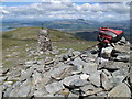
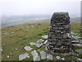
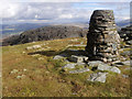
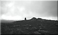
At 623m Moel Ysgyfarnogod is at the northern end of the Rhinogau range of mountains. It can be ascended from either Trawsfynydd to the east or Talsarnau to the west. Either rout is extremely challenging.
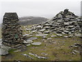
The summit can be identified by a large cairn next to a trig point. There are at least another two cairns identified about the massive, however one in particular appears to be a walker cairn and the other suggests a cist burial but I'm not convinced.
This is a dramatic landscape with mountain lakes and signs of quarrying particularly on the western side. The views from the summit are glorious.
You may be viewing yesterday's version of this page. To see the most up to date information please register for a free account.
")
")
")
")
Do not use the above information on other web sites or publications without permission of the contributor.
Nearby Images from Geograph Britain and Ireland:
©2013(licence)
©2009(licence)
©2019(licence)
©2012(licence)
©2020(licence)
The above images may not be of the site on this page, they are loaded from Geograph.
Please Submit an Image of this site or go out and take one for us!
Click here to see more info for this site
Nearby sites
Key: Red: member's photo, Blue: 3rd party photo, Yellow: other image, Green: no photo - please go there and take one, Grey: site destroyed
Download sites to:
KML (Google Earth)
GPX (GPS waypoints)
CSV (Garmin/Navman)
CSV (Excel)
To unlock full downloads you need to sign up as a Contributory Member. Otherwise downloads are limited to 50 sites.
Turn off the page maps and other distractions
Nearby sites listing. In the following links * = Image available
1.2km NNW 337° Hut Circles North West of Moel Ddinas* Ancient Village or Settlement (SH654357)
1.3km WNW 302° Bryn Cader Faner* Ring Cairn (SH64793529)
1.3km WNW 286° Llyn Eiddew Ring Cairn* Ring Cairn (SH64603498)
1.3km NNW 334° Nant Pasgan Bach Hut Circle Settlement.* Ancient Village or Settlement (SH653358)
1.4km WNW 292° Bryn Cader Faner Hut Circles* Ancient Village or Settlement (SH64543517)
1.5km WNW 296° Stones North East of Llyn Caerwych* Standing Stones (SH645353)
1.6km W 268° Llyn Eiddew Bach Stone Rows* Stone Row / Alignment (SH6421534589)
1.6km W 268° Llyn Eiddew Bach Ring Cairn 1* Ring Cairn (SH6421534588)
1.6km W 269° Llyn Eiddew Bach III* Ring Cairn (SH642346)
1.6km NNE 22° Cwm Moch Hut Circle* Ancient Village or Settlement (SH665361)
1.7km NNE 21° Cwm Moch Settlement* Ancient Village or Settlement (SH665362)
1.8km N 1° Nant Pasgan Mawr Standing Stone* Standing Stone (Menhir) (SH65913635)
1.8km WNW 303° Moel Geifr Hut Circles Ancient Village or Settlement (SH644356)
1.8km N 355° Nant Pasgan Mawr Hut Circle* Ancient Village or Settlement (SH65753635)
1.8km NW 306° Y Gyrn Hut Circle Settlement* Ancient Village or Settlement (SH64433568)
1.8km W 265° Taith Ardudwy* Ancient Trackway (SH640345)
1.9km NE 44° Cairn and cist south of Craig Y Gwynt* Cairn (SH672359)
1.9km W 264° Cairn, S of llyn Caerwych* Round Cairn (SH63943444)
1.9km W 266° Afon Eisingrug Hut Circle* Ancient Village or Settlement (SH639345)
1.9km W 263° Afon Eisingrug Cairns* Barrow Cemetery (SH639344)
2.0km NE 51° Hut Circle West of Moelfryn Isaf* Ancient Village or Settlement (SH674358)
2.0km NE 43° Cairn North of Taith Cambria* Cairn (SH6723535997)
2.1km NE 38° Craig Y Gwynt Cairn* Cairn (SH672362)
2.1km NW 304° Y Gyrn* Cairn (SH64093584)
2.2km W 269° Hut Circle Settlement South East of Moel Y Geifr* Ancient Village or Settlement (SH63653460)
View more nearby sites and additional images


 We would like to know more about this location. Please feel free to add a brief description and any relevant information in your own language.
 Wir möchten mehr über diese Stätte erfahren. Bitte zögern Sie nicht, eine kurze Beschreibung und relevante Informationen in Deutsch hinzuzufügen.
 Nous aimerions en savoir encore un peu sur les lieux. S'il vous plaît n'hesitez pas à ajouter une courte description et tous les renseignements pertinents dans votre propre langue.
 Quisieramos informarnos un poco más de las lugares. No dude en añadir una breve descripción y otros datos relevantes en su propio idioma.