Featured: Lost Secrets - an adventure during Neolithic times

Lost Secrets - an adventure during Neolithic times

See Your Book Here

See Your Book Here

Who's Online

There are currently, 288 guests and 6 members online.

You are a guest. To join in, please register for free by clicking here

Sponsors

<< Our Photo Pages >> Gillies Hill - Hillfort in Scotland in Stirling

Submitted by Andy B on Monday, 26 November 2007  Page Views: 12490

Iron Age and Later PrehistorySite Name: Gillies Hill
Country: Scotland
NOTE: This site is 1.188 km away from the location you searched for.

County: Stirling Type: Hillfort
Nearest Town: Stirling  Nearest Village: Cambusbarron
Map Ref: NS76879176
Latitude: 56.102692N  Longitude: 3.981182W
Condition:
5Perfect
4Almost Perfect
3Reasonable but with some damage
2Ruined but still recognisable as an ancient site
1Pretty much destroyed, possibly visible as crop marks
0No data.
-1Completely destroyed
no data Ambience:
5Superb
4Good
3Ordinary
2Not Good
1Awful
0No data.
no data Access:
5Can be driven to, probably with disabled access
4Short walk on a footpath
3Requiring a bit more of a walk
2A long walk
1In the middle of nowhere, a nightmare to find
0No data.
no data Accuracy:
5co-ordinates taken by GPS or official recorded co-ordinates
4co-ordinates scaled from a detailed map
3co-ordinates scaled from a bad map
2co-ordinates of the nearest village
1co-ordinates of the nearest town
0no data
5
Be the first person to rate this site - see the 'Contribute!' box in the right hand menu.

Internal Links:
External Links:

Gillies Hill
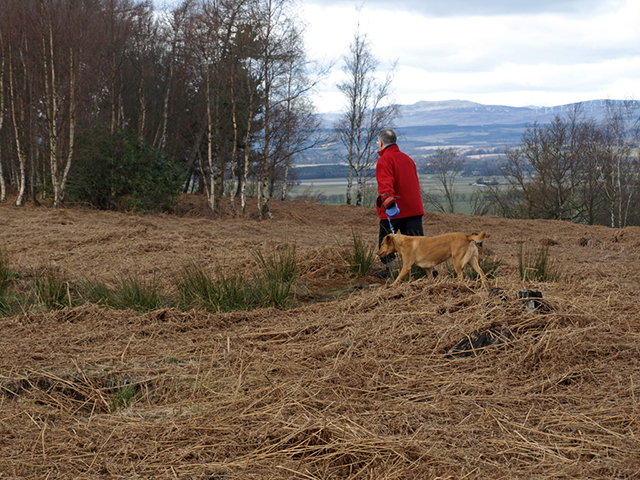
Gillies Hill submitted by peigimccann : Slope beneath the Gillies Hill Hill Fort (Vote or comment on this photo)
Hillfort in Stirling

Iron Age Fort with Scheduled Ancient Monument status. Under threat from quarrying in the locality.

See this news item for more on the quarrying.

For more information see Canmore ID 46246 which contains drawings from 1957 and photographs from the 1984 excavation.

The Wikipedia entry for this location says: "Gillies Hill is the hill from which Robert the Bruce’s camp followers, or Gillies, descended onto the field of the Battle of Bannockburn in 1314."

Note: Scottish Parliament backs Quarry Protest, see latest comment
You may be viewing yesterday's version of this page. To see the most up to date information please register for a free account.


Gillies Hill
Gillies Hill submitted by peigimccann : View from hill fort (Vote or comment on this photo)

Gillies Hill
Gillies Hill submitted by peigimccann : Rocks below hill fort (Vote or comment on this photo)

Gillies Hill
Gillies Hill submitted by peigimccann : Rampart rocks (Vote or comment on this photo)

Gillies Hill
Gillies Hill submitted by peigimccann : Slightly elevated outer rampart (Vote or comment on this photo)

Gillies Hill
Gillies Hill submitted by peigimccann : Rampart crossing current trail (Vote or comment on this photo)

Gillies Hill
Gillies Hill submitted by durhamnature : Urn from the site, from "Bronze Age Pottery" via archive.org

Do not use the above information on other web sites or publications without permission of the contributor.
Click here to see more info for this site

Nearby sites

Click here to view sites on an interactive OS map

Key: Red: member's photo, Blue: 3rd party photo, Yellow: other image, Green: no photo - please go there and take one, Grey: site destroyed

Download sites to:
KML (Google Earth)
GPX (GPS waypoints)
CSV (Garmin/Navman)
CSV (Excel)

To unlock full downloads you need to sign up as a Contributory Member. Otherwise downloads are limited to 50 sites.


Turn off the page maps and other distractions

Nearby sites listing. In the following links * = Image available
 955m SSW 194° Castlehill Dun* Stone Fort or Dun (NS76619084)
 1.1km SSE 146° Wallstale Dun* Stone Fort or Dun (NS77449085)
 1.1km ESE 116° Boiling Springs (Cambusbarron) Holy Well or Sacred Spring (NS77879124)
 1.1km S 183° Wester Craigend Dun* Stone Fort or Dun (NS7677790621)
 1.2km NE 50° Chapel Well (Cambusbarron)* Holy Well or Sacred Spring (NS77819251)
 1.4km NE 52° Birkill House Cairn (NS780926)
 1.6km NE 36° St Thomas's Well (Cambusbarron)* Holy Well or Sacred Spring (NS7788493056)
 1.7km NE 48° Douglas Terrace (Cambusbarron) Cairn (NS782929)
 1.8km ENE 59° Coneypark Nursery (Cambusbarron)* Cairn (NS78409263)
 1.9km NE 49° King's Park Cup and Rings* Rock Art (NS7837892998)
 2.0km WSW 243° Castlehill Wood Dun* Stone Fort or Dun (NS75089090)
 2.7km ENE 74° Randolphfield Stones* Standing Stones (NS79449244)
 3.0km NE 42° Butt Well* Holy Well or Sacred Spring (NS78949389)
 3.0km ENE 77° Wester Livilands* Broch or Nuraghe (NS7979692369)
 3.1km ENE 64° St Ninian's Well (Stirling)* Holy Well or Sacred Spring (NS7969093012)
 3.1km WNW 282° St Corbet's Well (Touch) Holy Well or Sacred Spring (NS738925)
 3.7km NE 40° Our Lady's Well (Stirling) Holy Well or Sacred Spring (NS79329454)
 4.0km SW 229° King's Yett (St Ninian's) Cairn (NS73738922)
 5.0km ESE 107° St Ninians Cursus Cursus (NS81599016)
 5.1km ESE 107° St Ninians Cursus Cursus (NS81679012)
 5.4km NE 40° Bel Stane (Causewayhead) Standing Stone (Menhir) (NS805958)
 5.6km NE 45° Abbey Craig Vitrified Fort* Hillfort (NS80949565)
 5.7km S 186° Loch Coulter Crannog* Crannog (NS761861)
 6.3km NNE 28° Lentran (Bridge of Allan) Cist (NS80039720)
 6.3km NE 34° Pathfoot Stone* Standing Stone (Menhir) (NS8060496871)
View more nearby sites and additional images

<< Cheung Chau Rock Carvings

Stone of Morphie >>

Please add your thoughts on this site

Prehistoric Dorset

Prehistoric Dorset

Sponsors

Auto-Translation (Google)

Translate from English into:

"Gillies Hill" | Login/Create an Account | 3 News and Comments
  
Go back to top of page    Comments are owned by the poster. We aren't responsible for their content.
Re: Scottish Parliament backs Quarry Protest by peigimccann on Sunday, 29 May 2011
(User Info | Send a Message)
The campaign to Save Gillies Hill continues.
You can visit the Save Gillies Hill website for the latest news
This is a link

>


  • [ Reply to This ]

    Scottish Parliament backs Quarry Protest by Anonymous on Monday, 26 November 2007
    QUARRY protestors in Cambusbarron were jubilant after they won the backing of the Scottish Parliament’s petitions committee last week.

    Calling for Holyrood to consider and debate the need for new legislation to protect historic sites such as the local Gillies Hill from destruction through mineral extraction the 3000-signature petition against plans by quarrying firm Hanson Aggregates Ltd to resume operations in the area was supported by Stirling MSP Bruce Crawford.

    Speaking on its behalf at the committee hearing last Tuesday (November 6) he told fellow MSPs: “During the 1980s, a considerable amount of quarrying took place.

    “At that time — I am reliably informed by local people — houses were damaged and lorries travelled at speed through the village of Cambusbarron.

    “An undertaking to tidy up the area and to replant trees was for years simply ignored.”

    He also argued community consultation was not as thorough as it could have been, claiming: “The permission for the quarry was affected by the 1995 environmental legislation and was reviewed in 2002, when it was casually extended until 2042. Therefore, the quarry has a fair bit of life left in it yet.

    “At that time, the community council was not consulted.

    “The statutory requirements were satisfied by placing a small notice in an edition of the Stirling Observer in 2002 that no one noticed, as might be expected in the circumstances.

    “No environmental impact assessment has ever been carried out. The first that locals knew about the prospect of renewed quarrying was when their homes were shaken by test blasting.”

    He also said there had been considerable changes to the local area since permission was originally granted, including the growth of Cambusbarron to almost twice its former size.

    “Town and country planning legislation allows for planning permission to be revoked where there has been a material change in conditions, so I have asked Stirling Council to examine that matter,” he said.

    Safety concerns were also an issue, he said, with the possibility of 25-tonne lorries travelling past four local schools on their way to and from the site, if work resumes.

    “During the day, there could be as much as one lorry every 12 minutes,” he said. “This is a disaster waiting to happen.”

    Committee members saw much merit in the petition with member recognising that the general issues raised went beyond Cambusbarron or even Stirling as a whole.

    Speaking afterwards a spokesperson for the local Save Gillies Hill group said: “We couldn’t have asked for a more positive response.

    “Every member of the Petitions Committee supported our stance, and although Holyrood has no power to intervene directly in this matter, the moral weight of the Scottish Parliament coming down so emphatically on our side of the argument is immense.”

    The committee agreed to write to a number of public bodies seeking their views including COSLA, Historic Scotland, Archaeology Scotland, Scottish Natural Heritage and the Scottish Environment Protection Agency (SEPA).
    Source: ICLanarkshire
    [ Reply to This ]

    Gillies Hill - Historic hill at centre of battle by Andy B on Wednesday, 20 June 2007
    (User Info | Send a Message)
    With its historic woodland, stunning scenery and protected wildlife, Gillies Hill is a well known and popular site for locals and visitors alike.

    Rare red squirrels, Peregrine Falcons, Buzzards and Roe Deer have been regularly spotted in the vast area of woodland near Cambusbarron, in Stirling.

    In addition it boasts Wellingtonia Firs and a Scots Pine which the Forestry Commission has designated as one of Scotland's top 100 heritage trees.

    But the hill is also steeped in history.

    An Iron Age Fort is located there and has Scheduled Ancient Monument status - a site designated as being of archaeological importance.

    More famously is the role it played in the Battle of Bannockburn.

    Gillies Hill is reputedly where Robert the Bruce's camp followers took shelter during the battle until their famous charge against the enemy on 24 June 1314.

    The followers emerged from the woods and the English army took fright, mistaking them for Scottish reinforcements.

    More than 600 years later, battle is about to commence again.

    This time, however, campaigners are fighting to stop the land from being demolished, not taken over.

    Two major companies are planning to restart quarrying on the site and their plans could see the whole woodland area being razed to the ground.

    More at BBC News:
    http://news.bbc.co.uk/1/hi/scotland/tayside_and_central/6568819.stm
    [ Reply to This ]

    Your Name: Anonymous [ Register Now ]
    Subject:


    Add your comment or contribution to this page. Spam or offensive posts are deleted immediately, don't even bother

    <<< What is five plus one as a number? (Please type the answer to this question in the little box on the left)
    You can also embed videos and other things. For Youtube please copy and paste the 'embed code'.
    For Google Street View please include Street View in the text.
    Create a web link like this: <a href="https://www.megalithic.co.uk">This is a link</a>  

    Allowed HTML is:
    <p> <b> <i> <a> <img> <em> <br> <strong> <blockquote> <tt> <li> <ol> <ul> <object> <param> <embed> <iframe>

    We would like to know more about this location. Please feel free to add a brief description and any relevant information in your own language.
    Wir möchten mehr über diese Stätte erfahren. Bitte zögern Sie nicht, eine kurze Beschreibung und relevante Informationen in Deutsch hinzuzufügen.
    Nous aimerions en savoir encore un peu sur les lieux. S'il vous plaît n'hesitez pas à ajouter une courte description et tous les renseignements pertinents dans votre propre langue.
    Quisieramos informarnos un poco más de las lugares. No dude en añadir una breve descripción y otros datos relevantes en su propio idioma.