


<< Our Photo Pages >> Pen Llithrig Y Wrach - Cairn in Wales in Conwy
Submitted by Postman on Saturday, 06 October 2012 Page Views: 3530
Neolithic and Bronze AgeSite Name: Pen Llithrig Y WrachCountry: Wales
NOTE: This site is 2.0 km away from the location you searched for.
County: Conwy Type: Cairn
Nearest Town: llanrwst
Map Ref: SH71606232
Latitude: 53.142508N Longitude: 3.921091W
Condition:
| 5 | Perfect |
| 4 | Almost Perfect |
| 3 | Reasonable but with some damage |
| 2 | Ruined but still recognisable as an ancient site |
| 1 | Pretty much destroyed, possibly visible as crop marks |
| 0 | No data. |
| -1 | Completely destroyed |
| 5 | Superb |
| 4 | Good |
| 3 | Ordinary |
| 2 | Not Good |
| 1 | Awful |
| 0 | No data. |
| 5 | Can be driven to, probably with disabled access |
| 4 | Short walk on a footpath |
| 3 | Requiring a bit more of a walk |
| 2 | A long walk |
| 1 | In the middle of nowhere, a nightmare to find |
| 0 | No data. |
| 5 | co-ordinates taken by GPS or official recorded co-ordinates |
| 4 | co-ordinates scaled from a detailed map |
| 3 | co-ordinates scaled from a bad map |
| 2 | co-ordinates of the nearest village |
| 1 | co-ordinates of the nearest town |
| 0 | no data |
Internal Links:
External Links:
I have visited· I would like to visit
PAB would like to visit
")
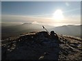
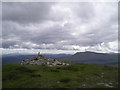
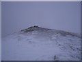
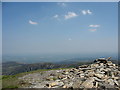
Pen llithrig Y Wrach is 799 metres high, and has a cairn on its rocky summit. It's not in very good condition, it has to be said but it's still there and recognisable after four thousand years.
It's a long way up and the cairn can't be seen from below so only a climb will do. It was so hot when the kids and I went up we took our boots off and made ourselves at home, for this is more like home to me than anywhere else.
You may be viewing yesterday's version of this page. To see the most up to date information please register for a free account.
")
")
")
Do not use the above information on other web sites or publications without permission of the contributor.
Nearby Images from Geograph Britain and Ireland:
©2020(licence)
©2012(licence)
©2005(licence)
©2006(licence)
©2006(licence)
The above images may not be of the site on this page, they are loaded from Geograph.
Please Submit an Image of this site or go out and take one for us!
Click here to see more info for this site
Nearby sites
Key: Red: member's photo, Blue: 3rd party photo, Yellow: other image, Green: no photo - please go there and take one, Grey: site destroyed
Download sites to:
KML (Google Earth)
GPX (GPS waypoints)
CSV (Garmin/Navman)
CSV (Excel)
To unlock full downloads you need to sign up as a Contributory Member. Otherwise downloads are limited to 50 sites.
Turn off the page maps and other distractions
Nearby sites listing. In the following links * = Image available
1.4km S 175° Maen Trichwmwd Natural Stone / Erratic / Other Natural Feature (SH7169260962)
1.4km S 178° Bwlch Cowlyd Hut Circles* Ancient Village or Settlement (SH716609)
1.5km S 178° Bwlch Cowlyd Cairn* Cairn (SH716608)
1.6km SSW 193° Cairn West of Bwlch Cowlyd* Cairn (SH712608)
1.9km SW 214° Tal y Braich* Stone Circle (SH705608)
1.9km SW 214° Tal y Braich Cairn and Standing Stone Cairn (SH70516079)
2.9km SW 234° Hut Circle Settlement SE of Glan Llugwy Ancient Village or Settlement (SH69226071)
3.9km WNW 301° Carnedd Llewelyn* Cairn (SH683644)
3.9km S 180° Creigiau'r Gelli Cairn Cairn (SH715584)
4.2km SSE 168° Clogwyn Mawr Hut Circle* Ancient Village or Settlement (SH7240058200)
4.2km SW 230° Gwern Gof Isaf* Ancient Village or Settlement (SH68265971)
4.3km NNW 346° Pant y Griafolen* Ancient Village or Settlement (SH707665)
4.3km SSW 203° Nant y Gors Cairn and Cist* Cairn (SH6980458433)
4.3km SSW 203° Nant y Gors Hut Circle Settlement* Ancient Village or Settlement (SH6982058413)
4.5km NW 321° Foel Grach* Cairn (SH68886589)
4.6km N 10° Clogwyn-yr-Eryr* Stone Row / Alignment (SH72506687)
4.8km SSE 159° Carnedd Coed Bryn Brethynau* Round Cairn (SH7319057750)
5.3km NE 42° Cae Du* Cairn (SH75206616)
5.3km N 356° Afon Garreg Wen* Standing Stone (Menhir) (SH71336761)
5.4km NNE 17° Hafodygors Wen* Ring Cairn (SH73366742)
5.5km W 275° Cairn SW of Carnedd Dafydd* Cairn (SH66136293)
5.5km W 274° Carnedd Dafydd (Conwy)* Cairn (SH661629)
5.8km W 271° Carnedd Fach* Cairn (SH6580062620)
5.8km NNE 28° Waen Bryn-Gwenith* Burial Chamber or Dolmen (SH74476738)
6.0km WSW 238° Sion a Siân (Adam and Eve) Stones* Natural Stone / Erratic / Other Natural Feature (SH664593)
View more nearby sites and additional images


 We would like to know more about this location. Please feel free to add a brief description and any relevant information in your own language.
 Wir möchten mehr über diese Stätte erfahren. Bitte zögern Sie nicht, eine kurze Beschreibung und relevante Informationen in Deutsch hinzuzufügen.
 Nous aimerions en savoir encore un peu sur les lieux. S'il vous plaît n'hesitez pas à ajouter une courte description et tous les renseignements pertinents dans votre propre langue.
 Quisieramos informarnos un poco más de las lugares. No dude en añadir una breve descripción y otros datos relevantes en su propio idioma.