

<< Our Photo Pages >> Castle Dyke (Chudleigh) - Hillfort in England in Devon
Submitted by vicky on Thursday, 25 March 2004 Page Views: 11451
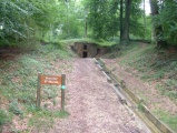
Iron Age and Later PrehistorySite Name: Castle Dyke (Chudleigh)Country: England
NOTE: This site is 0.291 km away from the location you searched for.
County: Devon Type: Hillfort
Nearest Town: Newton Abbot Nearest Village: Chudleigh
Map Ref: SX875787 Landranger Map Number: 192
Latitude: 50.597149N Longitude: 3.590887W
Condition:
| 5 | Perfect |
| 4 | Almost Perfect |
| 3 | Reasonable but with some damage |
| 2 | Ruined but still recognisable as an ancient site |
| 1 | Pretty much destroyed, possibly visible as crop marks |
| 0 | No data. |
| -1 | Completely destroyed |
| 5 | Superb |
| 4 | Good |
| 3 | Ordinary |
| 2 | Not Good |
| 1 | Awful |
| 0 | No data. |
| 5 | Can be driven to, probably with disabled access |
| 4 | Short walk on a footpath |
| 3 | Requiring a bit more of a walk |
| 2 | A long walk |
| 1 | In the middle of nowhere, a nightmare to find |
| 0 | No data. |
| 5 | co-ordinates taken by GPS or official recorded co-ordinates |
| 4 | co-ordinates scaled from a detailed map |
| 3 | co-ordinates scaled from a bad map |
| 2 | co-ordinates of the nearest village |
| 1 | co-ordinates of the nearest town |
| 0 | no data |
Internal Links:
External Links:
I have visited· I would like to visit
Mabel_Smith would like to visit
 (PID:86535)")
Have you visited this site? Please add a comment below.
You may be viewing yesterday's version of this page. To see the most up to date information please register for a free account.
 (PID:105478)")
 (PID:105477)")
 (PID:105476)")
 (PID:105475)")
 (PID:105474)")
 (PID:86543)")
 (PID:86542)")
Do not use the above information on other web sites or publications without permission of the contributor.
Click here to see more info for this site
Nearby sites
Key: Red: member's photo, Blue: 3rd party photo, Yellow: other image, Green: no photo - please go there and take one, Grey: site destroyed
Download sites to:
KML (Google Earth)
GPX (GPS waypoints)
CSV (Garmin/Navman)
CSV (Excel)
To unlock full downloads you need to sign up as a Contributory Member. Otherwise downloads are limited to 50 sites.
Turn off the page maps and other distractions
Nearby sites listing. In the following links * = Image available
959m W 266° Pixie's Hole Cave or Rock Shelter (SX86547865)
1.0km W 267° Cow Cave Cave or Rock Shelter (SX86477866)
4.9km ESE 109° Castle Dyke (Devon)* Ancient Village or Settlement (SX92147700)
5.4km SE 134° Whitewell Woods Well* Holy Well or Sacred Spring (SX913749)
5.5km W 268° St Mary's Well (Bovey Tracey)* Holy Well or Sacred Spring (SX820786)
5.5km ESE 117° Lidwell* Holy Well or Sacred Spring (SX924761)
6.1km W 270° The Bovey Stone Ancient Cross (SX8141778843)
7.6km S 186° Newton Abbot Museum* Museum (SX866712)
7.6km WNW 300° Tottiford Reservoir* Standing Stones (SX810827)
7.7km WNW 303° Tottiford Reservoir Row S* Stone Row / Alignment (SX81138309)
7.7km WNW 304° Tottiford Reservoir cairns* Cairn (SX81138312)
7.8km WNW 304° Tottiford Reservoir mound* Ancient Village or Settlement (SX81118313)
7.8km WNW 304° Tottiford Reservoir circle* Stone Circle (SX81098314)
7.8km NW 304° Tottiford Reservoir Row N* Stone Row / Alignment (SX81078320)
8.2km SSW 199° Newton Abbot Fort Hillfort (SX846710)
8.8km S 173° Milber Down Camp* Hillfort (SX884699)
9.3km WNW 286° Bishop's Stone (Lustleigh)* Ancient Cross (SX7860281532)
9.3km WNW 285° Datuidoc's Stone* Early Christian Sculptured Stone (SX7850081274)
10.0km S 172° Doda Well* Holy Well or Sacred Spring (SX887688)
10.4km S 188° Ladywell (Abbotskerswell)* Holy Well or Sacred Spring (SX858684)
10.4km WNW 290° Higher Combe Cross* Ancient Cross (SX7776482535)
10.8km WNW 288° South Harton Cross* Ancient Cross (SX7724982273)
10.9km W 272° Trendlebere Down Stone Row Cairn* Cairn (SX7662079230)
10.9km W 272° Trendlebere Down* Multiple Stone Rows / Avenue (SX76627928)
10.9km W 266° Haytor Down Ring Cairn (SX76617814)
View more nearby sites and additional images


 We would like to know more about this location. Please feel free to add a brief description and any relevant information in your own language.
 Wir möchten mehr über diese Stätte erfahren. Bitte zögern Sie nicht, eine kurze Beschreibung und relevante Informationen in Deutsch hinzuzufügen.
 Nous aimerions en savoir encore un peu sur les lieux. S'il vous plaît n'hesitez pas à ajouter une courte description et tous les renseignements pertinents dans votre propre langue.
 Quisieramos informarnos un poco más de las lugares. No dude en añadir una breve descripción y otros datos relevantes en su propio idioma.