


<< Our Photo Pages >> Trémarche menhir - Standing Stone (Menhir) in France in Bretagne:Côtes-D'Armor (22)
Submitted by thecaptain on Tuesday, 27 February 2007 Page Views: 4199
Neolithic and Bronze AgeSite Name: Trémarche menhir Alternative Name: menhir de Saint-Samson, Menhir de Tremarc’hCountry: France
NOTE: This site is 1.022 km away from the location you searched for.
Département: Bretagne:Côtes-D'Armor (22) Type: Standing Stone (Menhir)
Nearest Town: Perros-Guirec Nearest Village: Trégastel
Latitude: 48.802200N Longitude: 3.4985W
Condition:
| 5 | Perfect |
| 4 | Almost Perfect |
| 3 | Reasonable but with some damage |
| 2 | Ruined but still recognisable as an ancient site |
| 1 | Pretty much destroyed, possibly visible as crop marks |
| 0 | No data. |
| -1 | Completely destroyed |
| 5 | Superb |
| 4 | Good |
| 3 | Ordinary |
| 2 | Not Good |
| 1 | Awful |
| 0 | No data. |
| 5 | Can be driven to, probably with disabled access |
| 4 | Short walk on a footpath |
| 3 | Requiring a bit more of a walk |
| 2 | A long walk |
| 1 | In the middle of nowhere, a nightmare to find |
| 0 | No data. |
| 5 | co-ordinates taken by GPS or official recorded co-ordinates |
| 4 | co-ordinates scaled from a detailed map |
| 3 | co-ordinates scaled from a bad map |
| 2 | co-ordinates of the nearest village |
| 1 | co-ordinates of the nearest town |
| 0 | no data |
Internal Links:
External Links:
I have visited· I would like to visit
TheCaptain visited on 16th Apr 2014 - their rating: Access: 5 Passed by in a front garden on the way to Ploumanach
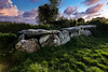
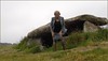
TheCaptain visited on 24th Jun 2005 - their rating: Cond: 3 Amb: 3 Access: 5 Pleasant enough menhir set into a little gravel area at the side of the D.11 road beside the junction at Trémarche a few kilometres to the south of Trégastel. It's about 3 metres high, of rectangular section, and made from a nice pink granite.
johnstone visited on 22nd Jun 2005 - their rating: Cond: 3 Amb: 3 Access: 5
TheCaptain visited on 30th May 1993 Cycling camping trip of north Brittany, day 2. Tregastel, Ile Grande, Tel Star Satellite place. Snake! Lots of ancient stones. All getting tired now, but it should be mostly downhill back to the campsite.
Average ratings for this site from all visit loggers: Condition: 3 Ambience: 3 Access: 5
")
It's about 3 metres high, of rectangular section, and made from a nice pink granite.
Base Mérimée (Historic Monument)
IMPORTANT NOTE: Positional co-ordinates taken from a gps receiver.
You may be viewing yesterday's version of this page. To see the most up to date information please register for a free account.
")
")
Do not use the above information on other web sites or publications without permission of the contributor.
TheCaptain has found this location on Google Street View:
Nearby Images from Flickr
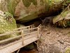
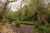
The above images may not be of the site on this page, but were taken nearby. They are loaded from Flickr so please click on them for image credits.
Click here to see more info for this site
Nearby sites
Click here to view sites on an interactive map of the areaKey: Red: member's photo, Blue: 3rd party photo, Yellow: other image, Green: no photo - please go there and take one, Grey: site destroyed
Download sites to:
KML (Google Earth)
GPX (GPS waypoints)
CSV (Garmin/Navman)
CSV (Excel)
To unlock full downloads you need to sign up as a Contributory Member. Otherwise downloads are limited to 50 sites.
Turn off the page maps and other distractions
Nearby sites listing. In the following links * = Image available
1.0km SSW 199° Lit de Saint-Samson* Natural Stone / Erratic / Other Natural Feature
1.0km SW 228° St Samson Chapel well* Holy Well or Sacred Spring
1.1km SW 226° Menhir a Vertu* Standing Stone (Menhir)
1.8km WNW 304° Kerguntuil allée couverte* Passage Grave
1.9km NW 306° Kerguntuil Dolmen* Burial Chamber or Dolmen
2.3km WNW 297° Menhir du Guern* Standing Stone (Menhir)
2.4km WNW 292° Menhir du Cleguer Standing Stone (Menhir)
2.9km NNW 341° Menhir de Keredol* Standing Stone (Menhir)
3.1km WNW 291° Allée Couverte de Min Meur* Passage Grave
3.2km W 272° Allée Couverte d'Evez-Bihan* Passage Grave
3.4km W 260° Keryvon allée couverte* Passage Grave
3.4km NNW 334° Le Roi Gradlon* Rock Outcrop
3.4km NNE 14° Oratoire de St Guirec* Ancient Temple
3.6km NNW 342° Roche tremblante (Trégastel)* Rock Outcrop
3.7km WSW 246° Saint-Uzec menhir* Standing Stone (Menhir)
3.8km NNW 341° Roche tremblante (Cos Porz)* Rock Outcrop
3.8km NNW 344° La Tête de Mort* Natural Stone / Erratic / Other Natural Feature
3.9km N 356° Ty-Lia (Ile Renote)* Passage Grave
4.0km NNE 17° Rochers de Ploumanac'h* Natural Stone / Erratic / Other Natural Feature
4.3km NNW 343° Rocher du Dé* Rock Outcrop
4.9km WSW 256° L'Armor menhir* Standing Stone (Menhir)
4.9km W 260° Prajou-Menhir menhir* Standing Stone (Menhir)
4.9km W 260° Prajou-Menhir allée couverte* Passage Grave
5.3km SE 131° Crec'h Quillé* Passage Grave
5.4km WSW 258° Parc-ar-Peulvennic* Standing Stone (Menhir)
View more nearby sites and additional images


 We would like to know more about this location. Please feel free to add a brief description and any relevant information in your own language.
 Wir möchten mehr über diese Stätte erfahren. Bitte zögern Sie nicht, eine kurze Beschreibung und relevante Informationen in Deutsch hinzuzufügen.
 Nous aimerions en savoir encore un peu sur les lieux. S'il vous plaît n'hesitez pas à ajouter une courte description et tous les renseignements pertinents dans votre propre langue.
 Quisieramos informarnos un poco más de las lugares. No dude en añadir una breve descripción y otros datos relevantes en su propio idioma.