


<< Text Pages >> Tarren Maerdy Cairn 1 - Cairn in Wales in Mid Glamorgan
Submitted by RayBray on Thursday, 12 August 2021 Page Views: 457
Neolithic and Bronze AgeSite Name: Tarren Maerdy Cairn 1Country: Wales
NOTE: This site is 0.927 km away from the location you searched for.
County: Mid Glamorgan Type: Cairn
Nearest Town: Maerdy
Map Ref: SS97959720
Latitude: 51.664281N Longitude: 3.476894W
Condition:
| 5 | Perfect |
| 4 | Almost Perfect |
| 3 | Reasonable but with some damage |
| 2 | Ruined but still recognisable as an ancient site |
| 1 | Pretty much destroyed, possibly visible as crop marks |
| 0 | No data. |
| -1 | Completely destroyed |
| 5 | Superb |
| 4 | Good |
| 3 | Ordinary |
| 2 | Not Good |
| 1 | Awful |
| 0 | No data. |
| 5 | Can be driven to, probably with disabled access |
| 4 | Short walk on a footpath |
| 3 | Requiring a bit more of a walk |
| 2 | A long walk |
| 1 | In the middle of nowhere, a nightmare to find |
| 0 | No data. |
| 5 | co-ordinates taken by GPS or official recorded co-ordinates |
| 4 | co-ordinates scaled from a detailed map |
| 3 | co-ordinates scaled from a bad map |
| 2 | co-ordinates of the nearest village |
| 1 | co-ordinates of the nearest town |
| 0 | no data |
Internal Links:
External Links:
Cairn in Mid Glamorgan
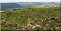
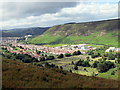
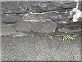
The walk up Mynydd Maerdy (Maerdy Mountain) took us about an hour from Maerdy, with wonderful views of the Rhondda Fach valley. The site is marked as a cairn on OS Maps. Although only a few metres off a path, it is barely visible in the long grass, as a slight mound. Upon closer inspection you are treated to the sight of it’s stone chamber, with 3 stone slab walls still intact!
Coflein.gov.uk describes the site as:
“ A round cairn approximately 9m diameter and 0.7m high. In the centre is a cist defined on three sides by pitched slabs, with smaller packing stones behind, 1.25 x 0.5m and 0.7m deep. The cairn is set back from the brow of the hill, and therefore there is no view to the valley below, only the hill opposite.
R Hayman, Hayman and Horton, 21 October 2009”.
You may be viewing yesterday's version of this page. To see the most up to date information please register for a free account.
Do not use the above information on other web sites or publications without permission of the contributor.
Nearby Images from Geograph Britain and Ireland:
©2017(licence)
©2016(licence)
©2016(licence)
©2011(licence)
©2023(licence)
The above images may not be of the site on this page, they are loaded from Geograph.
Please Submit an Image of this site or go out and take one for us!
Click here to see more info for this site
Nearby sites
Key: Red: member's photo, Blue: 3rd party photo, Yellow: other image, Green: no photo - please go there and take one, Grey: site destroyed
Download sites to:
KML (Google Earth)
GPX (GPS waypoints)
CSV (Garmin/Navman)
CSV (Excel)
To unlock full downloads you need to sign up as a Contributory Member. Otherwise downloads are limited to 50 sites.
Turn off the page maps and other distractions
Nearby sites listing. In the following links * = Image available
2.3km WSW 242° Treorchy Gorsedd Circle* Modern Stone Circle etc (SS9585596145)
3.0km S 187° Mynydd Y Gelli* Stone Circle (SS975942)
3.4km SE 140° St Mary's Well (West Glamorgan)* Holy Well or Sacred Spring (ST00079455)
4.0km SW 231° Bwlch y Clawdd Cairn Cairn (SS948948)
4.5km SW 223° Craig y Geifr Cairn (SS94809395)
4.8km SW 234° Bwlch y Clawdd* Modern Stone Circle etc (SS94039450)
5.1km SSE 152° Mynydd Brith-Weunydd Cairn (ST00279263)
5.2km SSW 210° Garn Fawr (Ogmore Valley)* Cairn (SS95229271)
5.9km SSW 201° Garn Fach Cairn (SS957917)
6.1km S 171° Carn-Y-Celyn* Cairn (SS98779114)
6.2km WSW 252° Crugyrafan* Round Barrow(s) (SS920954)
6.5km SW 224° Burry Holms Fort Hillfort (SS933926)
6.9km W 269° Pebyll Cairn* Ring Cairn (SS9108097239)
7.1km SW 236° Carn-Y-Hyrddod* Cairn (SS91999339)
7.1km S 181° Mynydd Maes-Teg Cairn (SS97699014)
7.2km W 276° Bachgen Carreg* Cairn (SS9081298111)
7.3km WSW 245° The Werfa Round Barrow(s) (SS913942)
7.3km W 270° Mynydd Blaengwynfi Cairn* Cairn (SS9060297368)
7.5km NW 308° Blaenrhondda Ancient Village* Ancient Village or Settlement (SN92160193)
7.8km SSW 192° Mynydd Maendy Cairn (SS96168964)
7.9km SSW 203° Bryn-Y-Cae Cairn (SS94689002)
7.9km WNW 282° Carn y Wiwer* Cairn (SS9019499035)
8.8km NW 314° Llyn Fawr* Holy Well or Sacred Spring (SN91770347)
9.1km NW 307° Carn Foesan Cairn (SN90780288)
9.2km SW 219° Garn Lwyd* Ring Cairn (SS9199090146)
View more nearby sites and additional images


 We would like to know more about this location. Please feel free to add a brief description and any relevant information in your own language.
 Wir möchten mehr über diese Stätte erfahren. Bitte zögern Sie nicht, eine kurze Beschreibung und relevante Informationen in Deutsch hinzuzufügen.
 Nous aimerions en savoir encore un peu sur les lieux. S'il vous plaît n'hesitez pas à ajouter une courte description et tous les renseignements pertinents dans votre propre langue.
 Quisieramos informarnos un poco más de las lugares. No dude en añadir una breve descripción y otros datos relevantes en su propio idioma.