


<< Our Photo Pages >> Talla Linnfoots - Cairn in Scotland in Scottish Borders
Submitted by Anne T on Monday, 23 July 2018 Page Views: 988
Neolithic and Bronze AgeSite Name: Talla Linnfoots Alternative Name: Coddleteth Burn (Talla Linnfoots); Talla ReservoirCountry: Scotland
NOTE: This site is 2.263 km away from the location you searched for.
County: Scottish Borders Type: Cairn
Nearest Town: Moffat Nearest Village: Tweedmuir
Map Ref: NT13622069
Latitude: 55.472379N Longitude: 3.368012W
Condition:
| 5 | Perfect |
| 4 | Almost Perfect |
| 3 | Reasonable but with some damage |
| 2 | Ruined but still recognisable as an ancient site |
| 1 | Pretty much destroyed, possibly visible as crop marks |
| 0 | No data. |
| -1 | Completely destroyed |
| 5 | Superb |
| 4 | Good |
| 3 | Ordinary |
| 2 | Not Good |
| 1 | Awful |
| 0 | No data. |
| 5 | Can be driven to, probably with disabled access |
| 4 | Short walk on a footpath |
| 3 | Requiring a bit more of a walk |
| 2 | A long walk |
| 1 | In the middle of nowhere, a nightmare to find |
| 0 | No data. |
| 5 | co-ordinates taken by GPS or official recorded co-ordinates |
| 4 | co-ordinates scaled from a detailed map |
| 3 | co-ordinates scaled from a bad map |
| 2 | co-ordinates of the nearest village |
| 1 | co-ordinates of the nearest town |
| 0 | no data |
Internal Links:
External Links:
I have visited· I would like to visit
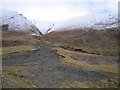
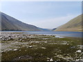
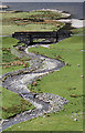
Anne T saw from a distance on 12th Jul 2018 - their rating: Cond: 2 Amb: 3 Access: 4 Cairn & Enclosure at south eastern end of Talla Reservoir: Our first, proper, stop of the day, as I can’t count the visit to Tweedmuir Kirk, as the stone we saw from from the 1600s.
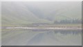
This is a remote, but very pretty spot, albeit with tall, brooding hills around, only tempered by the gentle trickling of the Coddleteth Burn, Games Hope Burn and Talla Water, which join up before entering the reservoir lake.
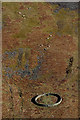
We were prevented from getting right up to this cairn and enclosure by a long, continuous deer fence. I think I’ve photographed the cairn, but we had difficulty in seeing the enclosure on the ground.
The enclosure can just be seen, very faintly, on UK Grid Reference Finder.
")
Marked on the OS map, the entry for Canmore ID 194236 simply says: "As part of the continuing re-survey of Tweeddale the following principal sites have been recorded: NT 136 207 Cairns and enclosure. A full report has been lodged with the NMRS. Sponsors: Biggar Museum Trust, Peeblesshire Archaeological Society."
We stopped at the south eastern end of the reservoir (near the bridge at Talla Linnfoots), armed with our GPS, but were unable to get only half way from the road to the cairn and enclosure, stopped by a lengthy, tall deer fence, which we couldn't find a way through.
Scanning the landscape, and estimating the position of the cairn on the map, we could see this long, low mound which lies just to the west of Coddleteth Burn. Whilst the vague outlines of an enclosure can be made out on UK Grid Reference Finder, some 100m to the north west of this cairn, which looks to be sited on a shallower slope than the rest of the hillside.
I'm not sure if I've photographed the right monument, but any advice on how best to reach this site would be appreciated.
You may be viewing yesterday's version of this page. To see the most up to date information please register for a free account.
Do not use the above information on other web sites or publications without permission of the contributor.
Nearby Images from Geograph Britain and Ireland:
©2013(licence)
©2017(licence)
©2012(licence)
©2013(licence)
©2012(licence)
The above images may not be of the site on this page, they are loaded from Geograph.
Please Submit an Image of this site or go out and take one for us!
Click here to see more info for this site
Nearby sites
Key: Red: member's photo, Blue: 3rd party photo, Yellow: other image, Green: no photo - please go there and take one, Grey: site destroyed
Download sites to:
KML (Google Earth)
GPX (GPS waypoints)
CSV (Garmin/Navman)
CSV (Excel)
To unlock full downloads you need to sign up as a Contributory Member. Otherwise downloads are limited to 50 sites.
Turn off the page maps and other distractions
Nearby sites listing. In the following links * = Image available
1.5km ESE 104° Megget Stone* Standing Stone (Menhir) (NT1505720292)
5.2km NW 308° Giant's Stone (Scottish Borders)* Standing Stone (Menhir) (NT09532399)
5.3km NW 307° Menzion* Standing Stones (NT0949023980)
6.0km WNW 290° Nether Dod* Stone Circle (NT08032279)
8.2km NNW 342° Patervan Settlement* Ancient Village or Settlement (NT11252854)
8.5km NNW 342° Patervan Cairn, Buildings & Mound* Cairn (NT11192885)
8.7km NNW 346° Norman's Castle* Stone Fort or Dun (NT11722915)
8.9km NNW 346° Laigh Hill (Tweeddale)* Ancient Village or Settlement (NT11632933)
9.7km NNE 29° Nethertown Stone Circle (NT185291)
10.0km NE 37° Manorhead Standing Stone (Menhir) (NT19862850)
10.6km N 351° Woodend, Mossfennan Farm* Cist (NT12173124)
11.3km SSE 166° Peatshiel Sike* Standing Stone (Menhir) (NT16190972)
13.1km N 349° Rachan Hill Henge (NT11423363)
13.5km N 350° Piper's Stone Standing Stone (Menhir) (NT11533400)
13.7km NNW 335° Knowe Kniffling* Hillfort (NT08163323)
13.7km N 1° Tinnis Castle* Hillfort (NT14153444)
13.8km NNW 337° Mill Rings Misc. Earthwork (NT08493357)
14.1km NNW 347° Whitslade Hill Burnt Mound Artificial Mound (NT10603447)
14.2km SSW 197° Moffat Well* Holy Well or Sacred Spring (NT0924007200)
14.7km N 355° Dreva Craig* Hillfort (NT12673533)
14.7km N 0° Drumelzier Haugh* Standing Stone (Menhir) (NT13933542)
14.8km N 354° Dreva Craig* Standing Stone (Menhir) (NT12453545)
14.8km N 356° Dreva Hill West (Broughton)* Ancient Village or Settlement (NT12923553)
14.9km NNW 349° Helm End Hillfort (NT10983532)
15.2km N 7° Altar Stone, Stobo* Standing Stone (Menhir) (NT15703573)
View more nearby sites and additional images


 We would like to know more about this location. Please feel free to add a brief description and any relevant information in your own language.
 Wir möchten mehr über diese Stätte erfahren. Bitte zögern Sie nicht, eine kurze Beschreibung und relevante Informationen in Deutsch hinzuzufügen.
 Nous aimerions en savoir encore un peu sur les lieux. S'il vous plaît n'hesitez pas à ajouter une courte description et tous les renseignements pertinents dans votre propre langue.
 Quisieramos informarnos un poco más de las lugares. No dude en añadir una breve descripción y otros datos relevantes en su propio idioma.