


<< Our Photo Pages >> Megget Stone - Standing Stone (Menhir) in Scotland in Scottish Borders
Submitted by vicky on Sunday, 22 December 2002 Page Views: 7297
Neolithic and Bronze AgeSite Name: Megget StoneCountry: Scotland County: Scottish Borders Type: Standing Stone (Menhir)
Nearest Town: Megget Nearest Village: Meggethead
Map Ref: NT1505720292 Landranger Map Number: 72
Latitude: 55.469056N Longitude: 3.345165W
Condition:
| 5 | Perfect |
| 4 | Almost Perfect |
| 3 | Reasonable but with some damage |
| 2 | Ruined but still recognisable as an ancient site |
| 1 | Pretty much destroyed, possibly visible as crop marks |
| 0 | No data. |
| -1 | Completely destroyed |
| 5 | Superb |
| 4 | Good |
| 3 | Ordinary |
| 2 | Not Good |
| 1 | Awful |
| 0 | No data. |
| 5 | Can be driven to, probably with disabled access |
| 4 | Short walk on a footpath |
| 3 | Requiring a bit more of a walk |
| 2 | A long walk |
| 1 | In the middle of nowhere, a nightmare to find |
| 0 | No data. |
| 5 | co-ordinates taken by GPS or official recorded co-ordinates |
| 4 | co-ordinates scaled from a detailed map |
| 3 | co-ordinates scaled from a bad map |
| 2 | co-ordinates of the nearest village |
| 1 | co-ordinates of the nearest town |
| 0 | no data |
Be the first person to rate this site - see the 'Contribute!' box in the right hand menu.
Internal Links:
External Links:
I have visited· I would like to visit
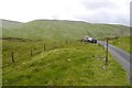
Anne T visited on 12th Jul 2018 - their rating: Cond: 3 Amb: 4 Access: 5 Megget Stone, east of Talla Reservoir: Continuing along the twisty, windy road that follows Talla Water, we passed an intrepid cyclist making his way slowly up the hills, and some motorcyclists who had stopped to photographs the waterfalls along the route.
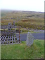
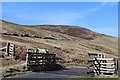
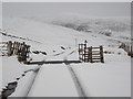
When we got to the grid reference given for the Megget Stone, we couldn’t see it at first, as it was hidden by the gate. There was room for a car to park just past the cattle grid and gate. Hopping out to take photographs and examine this stone in more detail, the cyclist past us, and as he did, I realised that at this point, it was downhill all the way – the watershed.
This stone is definitely a boundary marker, not a true standing stone. It looks as if its eastern face has been broken. In a remote but lovely spot.
")
For more information see Canmore site no. 49794, which says this stone lies by the side of the Megget-Talla road, at the watershed, at the boundary between Selkirkshire and Peebleshire.
An extract from the Canmore entry from 1950 reads: "The stone is a slab of gritty greywacke, 7 1/2 ins thick, showing traces of dressing along both sides; its height, measured on the W side, is 3 ft 4 ins, but the E side shows a step or shoulder, 3 1/2 ins deep and apparently artificial, at 2 ft 9 ins above ground level. Just below the shoulder the N face is 13 ins broad, and at ground level 11 ins."
You may be viewing yesterday's version of this page. To see the most up to date information please register for a free account.
")
")
")
")
Do not use the above information on other web sites or publications without permission of the contributor.
Nearby Images from Geograph Britain and Ireland:
©2011(licence)
©2013(licence)
©2015(licence)
©2013(licence)
©2020(licence)
The above images may not be of the site on this page, they are loaded from Geograph.
Please Submit an Image of this site or go out and take one for us!
Click here to see more info for this site
Nearby sites
Key: Red: member's photo, Blue: 3rd party photo, Yellow: other image, Green: no photo - please go there and take one, Grey: site destroyed
Download sites to:
KML (Google Earth)
GPX (GPS waypoints)
CSV (Garmin/Navman)
CSV (Excel)
To unlock full downloads you need to sign up as a Contributory Member. Otherwise downloads are limited to 50 sites.
Turn off the page maps and other distractions
Nearby sites listing. In the following links * = Image available
1.5km WNW 284° Talla Linnfoots* Cairn (NT13622069)
6.6km WNW 303° Giant's Stone (Scottish Borders)* Standing Stone (Menhir) (NT09532399)
6.7km WNW 302° Menzion* Standing Stones (NT0949023980)
7.4km WNW 288° Nether Dod* Stone Circle (NT08032279)
9.1km NNW 334° Patervan Settlement* Ancient Village or Settlement (NT11252854)
9.4km NNW 335° Patervan Cairn, Buildings & Mound* Cairn (NT11192885)
9.4km NNE 20° Nethertown Stone Circle (NT185291)
9.5km NNW 338° Norman's Castle* Stone Fort or Dun (NT11722915)
9.5km NNE 29° Manorhead Standing Stone (Menhir) (NT19862850)
9.7km NNW 338° Laigh Hill (Tweeddale)* Ancient Village or Settlement (NT11632933)
10.6km S 173° Peatshiel Sike* Standing Stone (Menhir) (NT16190972)
11.3km NNW 344° Woodend, Mossfennan Farm* Cist (NT12173124)
13.8km NNW 344° Rachan Hill Henge (NT11423363)
14.1km NNW 344° Piper's Stone Standing Stone (Menhir) (NT11533400)
14.2km N 355° Tinnis Castle* Hillfort (NT14153444)
14.3km SSW 203° Moffat Well* Holy Well or Sacred Spring (NT0924007200)
14.5km NE 53° Bught Rig Standing Stones (NT26852876)
14.6km NNW 331° Knowe Kniffling* Hillfort (NT08163323)
14.8km NNW 333° Mill Rings Misc. Earthwork (NT08493357)
14.8km NNW 341° Whitslade Hill Burnt Mound Artificial Mound (NT10603447)
14.9km NE 54° Douglas Water SE Stone Circle (NT273288)
14.9km NE 54° Douglas Water NW* Stone Circle (NT273288)
15.2km N 355° Drumelzier Haugh* Standing Stone (Menhir) (NT13933542)
15.2km N 350° Dreva Craig* Hillfort (NT12673533)
15.4km N 349° Dreva Craig* Standing Stone (Menhir) (NT12453545)
View more nearby sites and additional images


 We would like to know more about this location. Please feel free to add a brief description and any relevant information in your own language.
 Wir möchten mehr über diese Stätte erfahren. Bitte zögern Sie nicht, eine kurze Beschreibung und relevante Informationen in Deutsch hinzuzufügen.
 Nous aimerions en savoir encore un peu sur les lieux. S'il vous plaît n'hesitez pas à ajouter une courte description et tous les renseignements pertinents dans votre propre langue.
 Quisieramos informarnos un poco más de las lugares. No dude en añadir una breve descripción y otros datos relevantes en su propio idioma.