


<< Our Photo Pages >> St Mungo's Well (Edinburgh) - Holy Well or Sacred Spring in Scotland in Midlothian
Submitted by KiwiBetsy on Saturday, 14 October 2006 Page Views: 12483
Springs and Holy WellsSite Name: St Mungo's Well (Edinburgh)Country: Scotland County: Midlothian Type: Holy Well or Sacred Spring
Nearest Town: Edinburgh
Map Ref: NT18346773
Latitude: 55.895743N Longitude: 3.307393W
Condition:
| 5 | Perfect |
| 4 | Almost Perfect |
| 3 | Reasonable but with some damage |
| 2 | Ruined but still recognisable as an ancient site |
| 1 | Pretty much destroyed, possibly visible as crop marks |
| 0 | No data. |
| -1 | Completely destroyed |
| 5 | Superb |
| 4 | Good |
| 3 | Ordinary |
| 2 | Not Good |
| 1 | Awful |
| 0 | No data. |
| 5 | Can be driven to, probably with disabled access |
| 4 | Short walk on a footpath |
| 3 | Requiring a bit more of a walk |
| 2 | A long walk |
| 1 | In the middle of nowhere, a nightmare to find |
| 0 | No data. |
| 5 | co-ordinates taken by GPS or official recorded co-ordinates |
| 4 | co-ordinates scaled from a detailed map |
| 3 | co-ordinates scaled from a bad map |
| 2 | co-ordinates of the nearest village |
| 1 | co-ordinates of the nearest town |
| 0 | no data |
Internal Links:
External Links:
I have visited· I would like to visit
feorag visited on 10th Jun 2010 - their rating: Cond: 3 Amb: 4 Access: 4
 (PID:24923)")
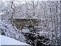
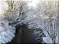
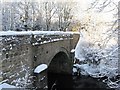
The well is on the bank of the Water of Leith and adjacent to Currie Kirk, which is reputed to be built on the foundations of the ancient Church of Kinleith and dedicated to St Kentigern (aka St Mungo) in 1276. The kirk in it’s present form dates from 1784. The first church was a cell close to the site of the well.
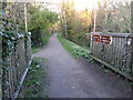
Take the A70 through Juniper Green and as you go into Currie take the 2nd turn to your left . Just of the A70 is a carpark. Park and follow the road down and cross the Leith. Just over the bridge take the Water of Leith path to your left and in a short distance the well will be on your right.
For more information see Canmore ID 50275. An entry from 1962 reads: "The well (name confirmed) is the centre of a marshy area where a stream issues from a spring. A church elder states that it was formerly used as a compensation well, and is mentioned in Currie Kirk Session records for 1872 when the railway was being built. He has no recollection of it ever having been covered."
A more recent entry on the Canmore record from December 1975 (their most recent entry) reads: "There is no sign of a well at or near the published site", although there is clearly a structure here from the photograph submitted!
You may be viewing yesterday's version of this page. To see the most up to date information please register for a free account.
 (PID:86640)")
 (PID:72672)")
 (PID:72671)")
 (PID:24924)")
Do not use the above information on other web sites or publications without permission of the contributor.
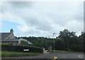
Nearby Images from Geograph Britain and Ireland:
©2007(licence)
©2010(licence)
©2015(licence)
©2010(licence)
©2013(licence)
The above images may not be of the site on this page, they are loaded from Geograph.
Please Submit an Image of this site or go out and take one for us!
Click here to see more info for this site
Nearby sites
Key: Red: member's photo, Blue: 3rd party photo, Yellow: other image, Green: no photo - please go there and take one, Grey: site destroyed
Download sites to:
KML (Google Earth)
GPX (GPS waypoints)
CSV (Garmin/Navman)
CSV (Excel)
To unlock full downloads you need to sign up as a Contributory Member. Otherwise downloads are limited to 50 sites.
Turn off the page maps and other distractions
Nearby sites listing. In the following links * = Image available
3.1km W 281° Newhouse Standing Stone Standing Stone (Menhir) (NT15296838)
4.9km W 259° Dalmahoy Hill Hillfort (NT135669)
4.9km NNE 14° Physic Well (Corstorphine)* Holy Well or Sacred Spring (NT19597252)
5.0km NNE 13° Lady Well* Holy Well or Sacred Spring (NT196726)
5.0km ENE 61° Craiglockart Hill Vitrified Fort Hillfort (NT22827006)
5.1km NW 325° Gogar Stone* Standing Stone (Menhir) (NT15487199)
5.5km WSW 256° Kaimes Standing Stones (NT130665)
5.6km ESE 105° Caerketton Hill* Cairn (NT23706621)
5.8km WNW 289° Tormain Hill* Rock Art (NT12906967)
5.9km E 83° Caiy Stane* Standing Stone (Menhir) (NT2424368357)
5.9km SE 127° Castle Knowe (Glencorse)* Ancient Village or Settlement (NT22996404)
5.9km WNW 289° Witches' Stone (Ratho)* Rock Art (NT12736973)
6.0km SE 129° Castle Law* Hillfort (NT2290063870)
6.1km WNW 302° Witchis Stane* Standing Stone (Menhir) (NT13177104)
6.1km E 84° Fairmiliehead (Edinburgh) Cairn (NT24466828)
6.1km E 79° 1, West Camus Road* Modern Stone Circle etc (NT2441068763)
6.2km SSE 160° Carnethy Hill cairn* Cairn (NT20386192)
6.3km ENE 75° Buck Stane* Standing Stone (Menhir) (NT24506922)
6.3km ESE 103° Hillend (Loanhead)* Hillfort (NT24526620)
6.8km ENE 64° Hanging Stanes (Braid Road)* Marker Stone (NT24517061)
6.9km W 262° Kirknewton stone Sculptured Stone (NT11426693)
7.0km N 352° Cammo Stone* Standing Stone (Menhir) (NT1747774681)
7.0km E 84° Galachlaw Cairn* Cairn (NT25366831)
7.1km SE 142° Marchwell (Glencourse) Stone Circle (NT22646211)
7.2km ENE 57° The Bore Stone* Marker Stone (NT2450871568)
View more nearby sites and additional images


 We would like to know more about this location. Please feel free to add a brief description and any relevant information in your own language.
 Wir möchten mehr über diese Stätte erfahren. Bitte zögern Sie nicht, eine kurze Beschreibung und relevante Informationen in Deutsch hinzuzufügen.
 Nous aimerions en savoir encore un peu sur les lieux. S'il vous plaît n'hesitez pas à ajouter une courte description et tous les renseignements pertinents dans votre propre langue.
 Quisieramos informarnos un poco más de las lugares. No dude en añadir una breve descripción y otros datos relevantes en su propio idioma.