


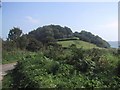
<< Our Photo Pages >> Sidbury Castle - Hillfort in England in Devon
Submitted by MattImpey on Friday, 22 June 2007 Page Views: 12417
Iron Age and Later PrehistorySite Name: Sidbury CastleCountry: England
NOTE: This site is 1.074 km away from the location you searched for.
County: Devon Type: Hillfort
Nearest Town: Sidbury
Map Ref: SY129913
Latitude: 50.714780N Longitude: 3.235077W
Condition:
| 5 | Perfect |
| 4 | Almost Perfect |
| 3 | Reasonable but with some damage |
| 2 | Ruined but still recognisable as an ancient site |
| 1 | Pretty much destroyed, possibly visible as crop marks |
| 0 | No data. |
| -1 | Completely destroyed |
| 5 | Superb |
| 4 | Good |
| 3 | Ordinary |
| 2 | Not Good |
| 1 | Awful |
| 0 | No data. |
| 5 | Can be driven to, probably with disabled access |
| 4 | Short walk on a footpath |
| 3 | Requiring a bit more of a walk |
| 2 | A long walk |
| 1 | In the middle of nowhere, a nightmare to find |
| 0 | No data. |
| 5 | co-ordinates taken by GPS or official recorded co-ordinates |
| 4 | co-ordinates scaled from a detailed map |
| 3 | co-ordinates scaled from a bad map |
| 2 | co-ordinates of the nearest village |
| 1 | co-ordinates of the nearest town |
| 0 | no data |
Be the first person to rate this site - see the 'Contribute!' box in the right hand menu.
Internal Links:
External Links:
I have visited· I would like to visit
lauraaurora saw from a distance on 21st Jan 2022
")
You may be viewing yesterday's version of this page. To see the most up to date information please register for a free account.
")
")
Do not use the above information on other web sites or publications without permission of the contributor.
coldrum has found this location on Google Street View:
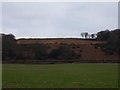
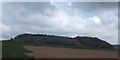
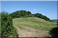
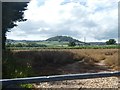
Nearby Images from Geograph Britain and Ireland:
©2011(licence)
©2012(licence)
©2006(licence)
©2020(licence)
©2008(licence)
The above images may not be of the site on this page, they are loaded from Geograph.
Please Submit an Image of this site or go out and take one for us!
Click here to see more info for this site
Nearby sites
Key: Red: member's photo, Blue: 3rd party photo, Yellow: other image, Green: no photo - please go there and take one, Grey: site destroyed
Download sites to:
KML (Google Earth)
GPX (GPS waypoints)
CSV (Garmin/Navman)
CSV (Excel)
To unlock full downloads you need to sign up as a Contributory Member. Otherwise downloads are limited to 50 sites.
Turn off the page maps and other distractions
Nearby sites listing. In the following links * = Image available
3.1km SSE 154° Salcombe Hill Standing Stone* Standing Stone (Menhir) (SY142885)
3.9km S 185° Sidmouth Museum* Museum (SY125874)
4.0km SSW 211° Seven Stones (Devon)* Stone Circle (SY10758787)
4.7km ENE 64° Broad Down Stone Circle (SY172933)
5.2km ENE 57° Broad Down* Barrow Cemetery (SY173940)
5.2km NNE 18° Farway & Gittisham Hill Cemetery* Barrow Cemetery (SY146962)
5.3km NE 36° Farway Castle Henge (SY1606395499)
5.3km NNE 28° Ring-in-the-Mire* Misc. Earthwork (SY1548695932)
5.9km ENE 78° Blackbury Camp* Hillfort (SY187924)
6.0km SSW 205° High Peak* Ancient Village or Settlement (SY103859)
7.3km W 271° Aylesbeare Common tumulus* Round Barrow(s) (SY056916)
8.7km WSW 242° Tor Barrow (Colaton Raleigh Common) Round Barrow(s) (SY05088737)
10.4km WSW 247° Woodbury Castle* Hillfort (SY032874)
10.5km E 86° Seaton Down Camp* Hillfort (SY23449185)
11.9km N 351° Hembury Fort* Hillfort (ST113031)
12.0km ENE 76° Colyton Church Cross* Ancient Cross (SY24599409)
13.4km E 88° Hawksdown Camp Hillfort (SY26299143)
13.5km NNE 19° Dumpdon Great Camp* Hillfort (ST176040)
14.3km N 0° Row Barrow (Devon)* Round Barrow(s) (ST13180561)
14.9km NE 40° Stockland Great Castle* Hillfort (ST22620262)
15.5km ENE 79° Musbury Castle* Hillfort (SY282941)
15.9km NE 38° Stockland Little Castle Hillfort (ST22980362)
16.5km WSW 256° Topsham Museum* Museum (SX9673987646)
16.8km NW 304° Holy Well (Broadclyst)* Holy Well or Sacred Spring (SS9914700962)
17.4km E 83° Shapwick Hill Bowl Barrows Barrow Cemetery (SY303930)
View more nearby sites and additional images


 We would like to know more about this location. Please feel free to add a brief description and any relevant information in your own language.
 Wir möchten mehr über diese Stätte erfahren. Bitte zögern Sie nicht, eine kurze Beschreibung und relevante Informationen in Deutsch hinzuzufügen.
 Nous aimerions en savoir encore un peu sur les lieux. S'il vous plaît n'hesitez pas à ajouter une courte description et tous les renseignements pertinents dans votre propre langue.
 Quisieramos informarnos un poco más de las lugares. No dude en añadir una breve descripción y otros datos relevantes en su propio idioma.