


<< Text Pages >> Llangollen Museum - Museum in Wales in Denbighshire
Submitted by coldrum on Thursday, 27 November 2008 Page Views: 3653
MuseumsSite Name: Llangollen MuseumCountry: Wales County: Denbighshire Type: Museum
Nearest Town: Llangollen
Map Ref: SJ2145642103
Latitude: 52.970507N Longitude: 3.171009W
Condition:
| 5 | Perfect |
| 4 | Almost Perfect |
| 3 | Reasonable but with some damage |
| 2 | Ruined but still recognisable as an ancient site |
| 1 | Pretty much destroyed, possibly visible as crop marks |
| 0 | No data. |
| -1 | Completely destroyed |
| 5 | Superb |
| 4 | Good |
| 3 | Ordinary |
| 2 | Not Good |
| 1 | Awful |
| 0 | No data. |
| 5 | Can be driven to, probably with disabled access |
| 4 | Short walk on a footpath |
| 3 | Requiring a bit more of a walk |
| 2 | A long walk |
| 1 | In the middle of nowhere, a nightmare to find |
| 0 | No data. |
| 5 | co-ordinates taken by GPS or official recorded co-ordinates |
| 4 | co-ordinates scaled from a detailed map |
| 3 | co-ordinates scaled from a bad map |
| 2 | co-ordinates of the nearest village |
| 1 | co-ordinates of the nearest town |
| 0 | no data |
Internal Links:
External Links:
I have visited· I would like to visit
SumDoood would like to visit
Museum with displays of local history from prehistory onwards.
5 Parade Street, Llangollen LL20 8NY
01978 862862
Daily, 10am-5pm (summer), 10am-4pm (winter)
Free entry, mostly run by volunteers
Website: Llangollen Museum
Facebook: Llangollen Museum
You may be viewing yesterday's version of this page. To see the most up to date information please register for a free account.
Do not use the above information on other web sites or publications without permission of the contributor.
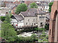
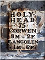
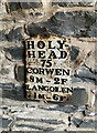
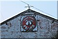
Nearby Images from Geograph Britain and Ireland:
©2010(licence)
©2019(licence)
©2023(licence)
©2021(licence)
©2012(licence)
The above images may not be of the site on this page, they are loaded from Geograph.
Please Submit an Image of this site or go out and take one for us!
Click here to see more info for this site
Nearby sites
Key: Red: member's photo, Blue: 3rd party photo, Yellow: other image, Green: no photo - please go there and take one, Grey: site destroyed
Download sites to:
KML (Google Earth)
GPX (GPS waypoints)
CSV (Garmin/Navman)
CSV (Excel)
To unlock full downloads you need to sign up as a Contributory Member. Otherwise downloads are limited to 50 sites.
Turn off the page maps and other distractions
Nearby sites listing. In the following links * = Image available
565m SE 140° Plas Newydd Gorsedd Stone circle* Modern Stone Circle etc (SJ2181041661)
1.2km NE 38° Dinas Bran* Hillfort (SJ2224043060)
2.2km WSW 238° Ffynnon Las Round Barrow(s) (SJ19574099)
2.5km SSE 157° Careg y Big (Llangollen)* Standing Stone (Menhir) (SJ224398)
2.5km NE 49° Bryngolen Cairn 1* Cairn (SJ23374372)
2.5km NE 39° Eglwyseg Plantation Cairn 1* Cairn (SJ23074403)
2.5km NNE 20° Eglwyseg Plantation Barrow* Round Barrow(s) (SJ22364446)
2.7km NNW 333° Pillar of Eliseg* Early Christian Sculptured Stone (SJ20264452)
2.8km NE 52° Brygolen Cairn 2 Cairn (SJ23664376)
2.8km NE 42° Eglwyseg Plantation Cairn 2 Cairn (SJ23344414)
2.9km NE 53° Brygolen Cairn 3* Cairn (SJ23794378)
2.9km NNE 22° Eglwyseg Stone* Natural Stone / Erratic / Other Natural Feature (SJ22574478)
2.9km NNE 14° Creigiau Eglwyseg 1* Round Barrow(s) (SJ22214495)
3.1km NNE 24° Eglwyseg stone (2)* Standing Stone (Menhir) (SJ22774494)
3.2km NNE 22° Eglwyseg Kerb Cairn A* Cairn (SJ22704509)
3.2km NNE 22° Eglwyseg Kerb Cairn B* Cairn (SJ227451)
3.3km NNE 23° Eglwyseg Cairn Circle* Cairn (SJ22824513)
3.4km NNE 25° Eglwyseg Mountain* Standing Stone (Menhir) (SJ22994519)
3.4km NNE 24° Creigiau Eglwyseg Boundary* Cairn (SJ22944522)
3.6km SSE 169° Llwynmawr* Standing Stone (Menhir) (SJ2211138530)
3.7km WSW 243° Blaen Nant* Round Barrow(s) (SJ18144051)
4.2km NNE 23° Eglwyseg mountain cairns (1,2 and 3)* Cairn (SJ23154597)
4.4km WSW 245° Nant-Y-Bache Round Barrow(s) (SJ17474031)
5.0km WSW 244° Vivod Mountain Cairn (SJ16964000)
5.8km ESE 105° Cae Carreg Lwyd Standing Stone (Menhir) (SJ270405)
View more nearby sites and additional images


 We would like to know more about this location. Please feel free to add a brief description and any relevant information in your own language.
 Wir möchten mehr über diese Stätte erfahren. Bitte zögern Sie nicht, eine kurze Beschreibung und relevante Informationen in Deutsch hinzuzufügen.
 Nous aimerions en savoir encore un peu sur les lieux. S'il vous plaît n'hesitez pas à ajouter une courte description et tous les renseignements pertinents dans votre propre langue.
 Quisieramos informarnos un poco más de las lugares. No dude en añadir una breve descripción y otros datos relevantes en su propio idioma.