


<< Our Photo Pages >> Hope Church Early Medieval Stones - Ancient Cross in Wales in Flintshire
Submitted by HowardMRW on Sunday, 26 April 2020 Page Views: 1942
Early Medieval (Dark Age)Site Name: Hope Church Early Medieval Stones Alternative Name: St Cyngar’s church, (also close to Wat's Dyke)Country: Wales County: Flintshire Type: Ancient Cross
Nearest Town: Wrexham Nearest Village: Hope
Map Ref: SJ310584
Latitude: 53.118294N Longitude: 3.032416W
Condition:
| 5 | Perfect |
| 4 | Almost Perfect |
| 3 | Reasonable but with some damage |
| 2 | Ruined but still recognisable as an ancient site |
| 1 | Pretty much destroyed, possibly visible as crop marks |
| 0 | No data. |
| -1 | Completely destroyed |
| 5 | Superb |
| 4 | Good |
| 3 | Ordinary |
| 2 | Not Good |
| 1 | Awful |
| 0 | No data. |
| 5 | Can be driven to, probably with disabled access |
| 4 | Short walk on a footpath |
| 3 | Requiring a bit more of a walk |
| 2 | A long walk |
| 1 | In the middle of nowhere, a nightmare to find |
| 0 | No data. |
| 5 | co-ordinates taken by GPS or official recorded co-ordinates |
| 4 | co-ordinates scaled from a detailed map |
| 3 | co-ordinates scaled from a bad map |
| 2 | co-ordinates of the nearest village |
| 1 | co-ordinates of the nearest town |
| 0 | no data |
Internal Links:
External Links:
")
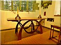
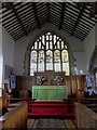
The carved stone was found in 2000 as a cut down and reshaped fragment found reused amidst rubble revealed during restoration work on the arcade wall between the north and south naves. Today, it is in the lady chapel wall: secure and safe but far away from its original context. It is a free-standing ring-cross carved from Cefn-y-Fedw sandstone, possibly a grave-marker according to Professor Nancy Edwards. The stone is without further ornament and so cannot be precisely dated. As with the other two, a ‘9th-11th century’ date-range is proposed by Edwards.
Given the simplistic nature of the carving, the absence of ‘Viking period’ ornamentation cannot really tell us much about either date or spheres of influence, sadly. Still, there are widespread parallels with other crosses in the Irish Sea orbit, including Ireland and the Isle of Man, showing that the early medieval origins of the Hopedale commote can be identified, as one might have expected, within the influence and connections of Chester and the North Wales coast. The closest parallel to all three stone-carved monuments from Hope is actually also from Flintshire, the cross-base from Dyserth (F3) (Edwards 2013: 355-356) near Prestatyn. The most elaborate ring-headed cross in North-East Wales is at Maen Achwyfan (Flintshire). So while generic at first glance, much can be said from this simple carved stone about the early medieval mortuary monuments of this part of present-day Wales.
Reference
Edwards, N. 2013. A Corpus of Early Medieval Inscribed Stones and Stone Sculpture in Wales. Volume III: North Wales. Cardiff: University of Wales Press.
More, with links at Prof Howard Williams' blog. (and more links in our comments below)
Note: Prof Howard MW Williams visits Hope Churchyard to discuss early Medieval stone monuments, linked in our comments
You may be viewing yesterday's version of this page. To see the most up to date information please register for a free account.
")
")
")
Do not use the above information on other web sites or publications without permission of the contributor.
Nearby Images from Geograph Britain and Ireland:
©2013(licence)
©2013(licence)
©2012(licence)
©2013(licence)
©2013(licence)
The above images may not be of the site on this page, they are loaded from Geograph.
Please Submit an Image of this site or go out and take one for us!
Click here to see more info for this site
Nearby sites
Key: Red: member's photo, Blue: 3rd party photo, Yellow: other image, Green: no photo - please go there and take one, Grey: site destroyed
Download sites to:
KML (Google Earth)
GPX (GPS waypoints)
CSV (Garmin/Navman)
CSV (Excel)
To unlock full downloads you need to sign up as a Contributory Member. Otherwise downloads are limited to 50 sites.
Turn off the page maps and other distractions
Nearby sites listing. In the following links * = Image available
982m WNW 293° Park in the Past* Museum (SJ301588)
1.1km SSE 157° Caer Estyn* Hillfort (SJ314574)
1.9km S 188° Siambr Gladdu Abermorddu* Cairn (SJ30695648)
2.8km SSW 197° Plas Maen Stone* Rock Art (SJ3015555755)
5.0km SE 133° The Atropos Altar Stone* Sculptured Stone (SJ34645497)
5.1km S 184° Bryn Y Gaer Hillfort and St Paul's Church Hillfort (SJ30585334)
5.2km SSE 155° Bryn Alyn* Hillfort (SJ33125370)
5.7km E 95° St Peter's Well (Denbighshire) Holy Well or Sacred Spring (SJ36735784)
6.1km W 269° Carreg-y-Llech* Standing Stone (Menhir) (SJ24875835)
6.5km W 267° Bryntirion Round Barrows* Round Barrow(s) (SJ2445058160)
6.8km W 264° Pen Y Stryt Barrow* Round Barrow(s) (SJ2423057830)
7.0km W 261° Pentre Round Barrow* Round Barrow(s) (SJ2401057440)
7.2km SSE 151° Wrexham Gorsedd Circle Modern Stone Circle etc (SJ3436752064)
7.4km SSW 213° Minera Cup Stone* Rock Art (SJ26875225)
7.7km SE 140° Borras Quarry Neolithic Village Ancient Village or Settlement (SJ35855243)
8.2km SSE 164° Wrexham County Borough Museum* Museum (SJ3318950455)
8.6km NW 309° Bryn-yr-Ellyllon* Round Barrow(s) (SJ2434063930)
9.0km SSE 166° Fairy Oak* Round Barrow(s) (SJ33144962)
9.1km NW 306° Mold Library and Museum* Museum (SJ237639)
9.3km E 89° Poulton Timber Circle* Ancient Village or Settlement (SJ4033558472)
9.3km SSE 164° Hillbury* Round Barrow(s) (SJ33424939)
9.4km NW 308° Standing Stone St Mary's Church* Standing Stone (Menhir) (SJ2363864213)
9.6km NW 308° Mold Gorsedd Circle Modern Stone Circle etc (SJ2352364421)
9.7km SW 232° Maes Maelor* Barrow Cemetery (SJ23275255)
10.2km WSW 248° Llyn Cyfynwy Round Cairn* Round Cairn (SJ215547)
View more nearby sites and additional images


 We would like to know more about this location. Please feel free to add a brief description and any relevant information in your own language.
 Wir möchten mehr über diese Stätte erfahren. Bitte zögern Sie nicht, eine kurze Beschreibung und relevante Informationen in Deutsch hinzuzufügen.
 Nous aimerions en savoir encore un peu sur les lieux. S'il vous plaît n'hesitez pas à ajouter une courte description et tous les renseignements pertinents dans votre propre langue.
 Quisieramos informarnos un poco más de las lugares. No dude en añadir una breve descripción y otros datos relevantes en su propio idioma.