


<< Our Photo Pages >> World Museum Liverpool - Museum in England in Merseyside
Submitted by vicky on Thursday, 26 February 2004 Page Views: 13201
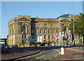
MuseumsSite Name: World Museum Liverpool Alternative Name: Liverpool MuseumCountry: England
NOTE: This site is 2.5 km away from the location you searched for.
County: Merseyside Type: Museum
Nearest Town: Liverpool
Map Ref: SJ348908 Landranger Map Number: 108
Latitude: 53.409966N Longitude: 2.9823W
Condition:
| 5 | Perfect |
| 4 | Almost Perfect |
| 3 | Reasonable but with some damage |
| 2 | Ruined but still recognisable as an ancient site |
| 1 | Pretty much destroyed, possibly visible as crop marks |
| 0 | No data. |
| -1 | Completely destroyed |
| 5 | Superb |
| 4 | Good |
| 3 | Ordinary |
| 2 | Not Good |
| 1 | Awful |
| 0 | No data. |
| 5 | Can be driven to, probably with disabled access |
| 4 | Short walk on a footpath |
| 3 | Requiring a bit more of a walk |
| 2 | A long walk |
| 1 | In the middle of nowhere, a nightmare to find |
| 0 | No data. |
| 5 | co-ordinates taken by GPS or official recorded co-ordinates |
| 4 | co-ordinates scaled from a detailed map |
| 3 | co-ordinates scaled from a bad map |
| 2 | co-ordinates of the nearest village |
| 1 | co-ordinates of the nearest town |
| 0 | no data |
Internal Links:
External Links:
I have visited· I would like to visit
TimPrevett has visited here
")
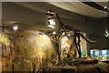
British Antiquity Collection including the Anderson collection of prehistoric pottery from Yorkshire
Address: William Brown Street, L3 8EN
Phone: 0151 478 4399
Opening Hours: Open Mon-Sat 10am-5pm, Sun 12-5pm. (check their web site)
Admission: Free
Visit their web site
You may be viewing yesterday's version of this page. To see the most up to date information please register for a free account.
Do not use the above information on other web sites or publications without permission of the contributor.
Nearby Images from Geograph Britain and Ireland:
©2008(licence)

©2015(licence)

©2019(licence)
©2010(licence)
©2010(licence)
The above images may not be of the site on this page, they are loaded from Geograph.
Please Submit an Image of this site or go out and take one for us!
Click here to see more info for this site
Nearby sites
Key: Red: member's photo, Blue: 3rd party photo, Yellow: other image, Green: no photo - please go there and take one, Grey: site destroyed
Download sites to:
KML (Google Earth)
GPX (GPS waypoints)
CSV (Garmin/Navman)
CSV (Excel)
To unlock full downloads you need to sign up as a Contributory Member. Otherwise downloads are limited to 50 sites.
Turn off the page maps and other distractions
Nearby sites listing. In the following links * = Image available
4.0km NNE 30° Modern stone circle on Cherry Avenue* Modern Stone Circle etc (SJ3687894265)
4.2km NNE 14° St Mary (Walton on the Hill) Ancient Cross (SJ35889482)
4.6km ESE 104° Monk's Well (Wavertree)* Holy Well or Sacred Spring (SJ39288959)
4.8km WSW 248° The Bonks Barrow Cemetery (SJ303891)
6.0km W 262° Bidston Hill Rock Carvings* Carving (SJ288900)
6.1km SE 134° Solomon's Tomb Modern Stone Circle etc (SJ391865)
6.4km ESE 119° The Calderstones* Chambered Tomb (SJ4040287622)
6.8km SE 130° Robin Hood's Stone* Standing Stone (Menhir) (SJ3997886383)
7.9km S 181° St Patrick's Well (Bromborough)* Holy Well or Sacred Spring (SJ34538295)
8.6km S 178° St Barnabas (Bromborough)* Ancient Cross (SJ3491082212)
8.6km WSW 256° Overchurch* Stone Circle (SJ264888)
9.1km ESE 123° Camp Hill (Woolton) Hillfort (SJ424858)
9.1km WSW 237° Arrowe Park standing stones Standing Stones (SJ27058596)
9.9km WSW 244° Greasby Copse Ancient Village or Settlement (SJ25788664)
10.5km N 3° St Helen's Well (Sefton) Holy Well or Sacred Spring (SD35450129)
11.7km W 268° Great Meols* Ancient Village or Settlement (SJ231906)
11.8km WSW 240° Thor's Stone* Natural Stone / Erratic / Other Natural Feature (SJ2447484933)
11.9km N 360° Lunt Meadows* Ancient Village or Settlement (SD349027)
12.1km S 191° Raby Mound Round Barrow(s) (SJ32377891)
12.9km WSW 244° Face Stone (Stapledon Wood)* Rock Outcrop (SJ23088536)
13.2km WSW 252° West Kirby Cremation Burial Cist (SJ22158678)
13.2km WSW 251° The Column* Chambered Tomb (SJ222866)
13.7km WSW 250° St Bridget (West Kirby)* Early Christian Sculptured Stone (SJ21828641)
14.4km SSW 202° St Mary and St Helen (Neston)* Ancient Cross (SJ29157749)
14.6km W 260° Red Rocks Ancient Mine, Quarry or other Industry (SJ20328843)
View more nearby sites and additional images


 We would like to know more about this location. Please feel free to add a brief description and any relevant information in your own language.
 Wir möchten mehr über diese Stätte erfahren. Bitte zögern Sie nicht, eine kurze Beschreibung und relevante Informationen in Deutsch hinzuzufügen.
 Nous aimerions en savoir encore un peu sur les lieux. S'il vous plaît n'hesitez pas à ajouter une courte description et tous les renseignements pertinents dans votre propre langue.
 Quisieramos informarnos un poco más de las lugares. No dude en añadir una breve descripción y otros datos relevantes en su propio idioma.