


<< Our Photo Pages >> Loxton Churchyard Cross - Ancient Cross in England in Somerset
Submitted by dooclay on Thursday, 06 July 2023 Page Views: 287
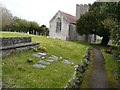
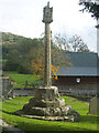
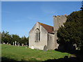
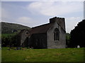
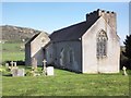
Early Medieval (Dark Age)Site Name: Loxton Churchyard CrossCountry: England County: Somerset Type: Ancient Cross
Nearest Village: Loxton
Map Ref: ST3762455813
Latitude: 51.298010N Longitude: 2.896042W
Condition:
| 5 | Perfect |
| 4 | Almost Perfect |
| 3 | Reasonable but with some damage |
| 2 | Ruined but still recognisable as an ancient site |
| 1 | Pretty much destroyed, possibly visible as crop marks |
| 0 | No data. |
| -1 | Completely destroyed |
| 5 | Superb |
| 4 | Good |
| 3 | Ordinary |
| 2 | Not Good |
| 1 | Awful |
| 0 | No data. |
| 5 | Can be driven to, probably with disabled access |
| 4 | Short walk on a footpath |
| 3 | Requiring a bit more of a walk |
| 2 | A long walk |
| 1 | In the middle of nowhere, a nightmare to find |
| 0 | No data. |
| 5 | co-ordinates taken by GPS or official recorded co-ordinates |
| 4 | co-ordinates scaled from a detailed map |
| 3 | co-ordinates scaled from a bad map |
| 2 | co-ordinates of the nearest village |
| 1 | co-ordinates of the nearest town |
| 0 | no data |
Internal Links:
External Links:
")
Source; Historic England
Churchyard cross. C15, major restoration 1910. Freestone. 3 step octagonal calvary, surmounted by square plinth with chamfered corners.
See Historic England List ID 1015514 for the scheduling information for this churchyard cross.
You may be viewing yesterday's version of this page. To see the most up to date information please register for a free account.
Do not use the above information on other web sites or publications without permission of the contributor.
Nearby Images from Geograph Britain and Ireland:
©2016(licence)
©2020(licence)
©2010(licence)
©2011(licence)
©2014(licence)
The above images may not be of the site on this page, they are loaded from Geograph.
Please Submit an Image of this site or go out and take one for us!
Click here to see more info for this site
Nearby sites
Key: Red: member's photo, Blue: 3rd party photo, Yellow: other image, Green: no photo - please go there and take one, Grey: site destroyed
Download sites to:
KML (Google Earth)
GPX (GPS waypoints)
CSV (Garmin/Navman)
CSV (Excel)
To unlock full downloads you need to sign up as a Contributory Member. Otherwise downloads are limited to 50 sites.
Turn off the page maps and other distractions
Nearby sites listing. In the following links * = Image available
1.6km NW 318° Loxton Hill Barrows Round Barrow(s) (ST36565704)
1.8km N 6° Flagstaff Hill* Stone Circle (ST3785257630)
2.0km ESE 102° Compton Bishop Church Cross* Ancient Cross (ST3959955378)
2.5km SSE 166° Biddisham Churchyard Cross* Ancient Cross (ST3819353429)
2.5km NE 34° Wook's Quoit* Standing Stone (Menhir) (ST39045783)
3.1km E 88° Wavering Down cairn* Round Cairn (ST40705590)
3.4km ESE 107° Compton Bishop* Standing Stones (ST409548)
3.7km WNW 287° Bleadon Cross* Ancient Cross (ST3411056921)
4.6km NE 45° Banwell Camp Hillfort (ST409590)
4.9km SE 129° Weare Churchyard Cross* Ancient Cross (ST4140952670)
5.1km SW 219° East Brent Churchyard Cross* Ancient Cross (ST3439051891)
5.5km N 11° Rolstone* Standing Stone (Menhir) (ST38736120)
5.7km ESE 102° Axbridge Church Wells* Holy Well or Sacred Spring (ST432546)
6.0km SW 215° Brent Knoll Camp* Hillfort (ST34115097)
6.3km ENE 64° The Wimblestone* Standing Stone (Menhir) (ST43355848)
6.4km WNW 289° Walborough Barrows Round Barrow(s) (ST31615791)
6.5km SSE 149° Chapel Allerton Cross* Ancient Cross (ST4089050199)
7.7km ENE 70° Barrow at Rowberrow* Round Barrow(s) (ST44925834)
7.8km NW 316° North Somerset Museum Museum (ST322615)
7.9km NW 316° Weston-super-Mare Museum* Museum (ST3217061568)
8.0km ENE 67° Dolebury Camp* Hillfort (ST450589)
8.0km S 176° Mark Village Cross* Ancient Cross (ST3804947838)
8.0km SW 216° Unknown earthworks at Edithmead* Misc. Earthwork (ST32864933)
8.1km E 81° Cuck Hill Barrow Round Barrow(s) (ST4567057030)
8.9km ESE 102° Flint Jack's Cave Cave or Rock Shelter (ST463538)
View more nearby sites and additional images


 We would like to know more about this location. Please feel free to add a brief description and any relevant information in your own language.
 Wir möchten mehr über diese Stätte erfahren. Bitte zögern Sie nicht, eine kurze Beschreibung und relevante Informationen in Deutsch hinzuzufügen.
 Nous aimerions en savoir encore un peu sur les lieux. S'il vous plaît n'hesitez pas à ajouter une courte description et tous les renseignements pertinents dans votre propre langue.
 Quisieramos informarnos un poco más de las lugares. No dude en añadir una breve descripción y otros datos relevantes en su propio idioma.