

<< Our Photo Pages >> Anglo Saxon Cross Base, Wetheral Parish Church - Ancient Cross in England in Cumbria
Submitted by Anne T on Wednesday, 02 March 2016 Page Views: 3376
Early Medieval (Dark Age)Site Name: Anglo Saxon Cross Base, Wetheral Parish Church Alternative Name: Ancient Cross Base at Wetheral Parish Church;Country: England
NOTE: This site is 0.129 km away from the location you searched for.
County: Cumbria Type: Ancient Cross
Nearest Town: Carlisle Nearest Village: Wetheral
Map Ref: NY46835436
Latitude: 54.881153N Longitude: 2.830255W
Condition:
| 5 | Perfect |
| 4 | Almost Perfect |
| 3 | Reasonable but with some damage |
| 2 | Ruined but still recognisable as an ancient site |
| 1 | Pretty much destroyed, possibly visible as crop marks |
| 0 | No data. |
| -1 | Completely destroyed |
| 5 | Superb |
| 4 | Good |
| 3 | Ordinary |
| 2 | Not Good |
| 1 | Awful |
| 0 | No data. |
| 5 | Can be driven to, probably with disabled access |
| 4 | Short walk on a footpath |
| 3 | Requiring a bit more of a walk |
| 2 | A long walk |
| 1 | In the middle of nowhere, a nightmare to find |
| 0 | No data. |
| 5 | co-ordinates taken by GPS or official recorded co-ordinates |
| 4 | co-ordinates scaled from a detailed map |
| 3 | co-ordinates scaled from a bad map |
| 2 | co-ordinates of the nearest village |
| 1 | co-ordinates of the nearest town |
| 0 | no data |
Internal Links:
External Links:
I have visited· I would like to visit
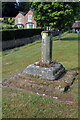
Anne T visited on 28th Feb 2016 - their rating: Cond: 3 Amb: 4 Access: 5 Anglo Saxon Cross Base, Wetheral, Cumbria: A notice in the guard house at the Priory Gatehouse mentioned boundary crosses, so I thought it might be worth investigating whether or not there were any fragments inside the church. As we walked up from the Eden River up Ferry Hill, with the churchyard to my right, there was a fragment of cross shaft with what looked to be an original cross base.
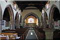
The church itself was locked, although there appeared to be a light on inside, but only in the vestry. A check on the Anglo Saxon Corpus site tells me that only one fragment of cross arm is recorded for Wetheral, and this is now in the possession of H M Calvin of St John’s College, Oxford (see Corpus of Anglo Saxon Stone Sculpture Record Cumbria 169). The cross base isn't recorded on the AS Corpus site, and I'll email for their opinion, but it looks so similar to others that we concluded it must be. I'll update the record when I hear.
")
Whilst only part of an Anglo Saxon cross arm fragment is recorded in the Corpus of Anglo Saxon Stone Sculpture website for Wetheral (now located in St John's College, Oxford), this ancient stone base is reminiscent of many other Anglo Saxon stone cross bases in Cumbria and Northumberland.
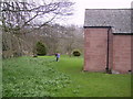
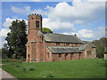
Located in a prominent position in the south east corner of Wetheral Parish Church churchyard, it is sited high above the nearby River Eden. An interpretation board at the nearby Wetheral Priory Gatehouse makes reference to a number of boundary crosses, so it seems reasonable to assume that the remains of one or two are still within the Priory boundaries.
Whilst the cross base itself seems to have a replacement shaft with a sundial placed on top, on closer inspection there are the remains of worn intertwined carvings which might well have been part of an Anglo Saxon Cross Shaft.
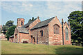
The church has an unusual octagonal tower, and was originally dedicated to St Constantine. It was locked at the time of our visit, so there was no access to a history of the church. I'll shortly be contacting the Anglo Saxon Corpus at Durham University to determine whether or not this has been missed from their catalogue.
Nearby is Wetheral Priory Gatehouse, St. Constantine's Cells and St. Cutherbert's Holy Well, all in a very pleasant setting by the River Eden.
You may be viewing yesterday's version of this page. To see the most up to date information please register for a free account.
")
")
Do not use the above information on other web sites or publications without permission of the contributor.
Nearby Images from Geograph Britain and Ireland:
©2023(licence)
©2008(licence)
©2023(licence)
©2023(licence)
©2012(licence)
The above images may not be of the site on this page, they are loaded from Geograph.
Please Submit an Image of this site or go out and take one for us!
Click here to see more info for this site
Nearby sites
Key: Red: member's photo, Blue: 3rd party photo, Yellow: other image, Green: no photo - please go there and take one, Grey: site destroyed
Download sites to:
KML (Google Earth)
GPX (GPS waypoints)
CSV (Garmin/Navman)
CSV (Excel)
To unlock full downloads you need to sign up as a Contributory Member. Otherwise downloads are limited to 50 sites.
Turn off the page maps and other distractions
Nearby sites listing. In the following links * = Image available
171m W 273° Wetheral Village Cross* Ancient Cross (NY4665954370)
608m N 350° St Cuthbert's Holy Well* Holy Well or Sacred Spring (NY46735496)
3.9km N 10° Cardinal Well (Irthington) Holy Well or Sacred Spring (NY4755058220)
3.9km S 179° St Anne's Well (Cotehill)* Holy Well or Sacred Spring (NY4684050420)
5.1km WSW 242° St Ninian's Well (Brisco)* Holy Well or Sacred Spring (NY42265201)
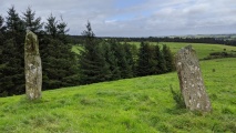
5.9km ESE 105° Carlatton Demesne* Standing Stone (Menhir) (NY5252352810)
6.3km ESE 122° Chapel Well (Cumwhitton) Holy Well or Sacred Spring (NY5209050930)
6.4km SSW 211° St Mary's Well (Wreay)* Holy Well or Sacred Spring (NY4352548921)
6.9km WNW 282° Carlisle Cross* Ancient Cross (NY4008455931)
7.0km WNW 292° Homeacres Holy Well (Stanwix)* Holy Well or Sacred Spring (NY40415709)
7.0km SSW 200° St Wilfred's Well (Wreay)* Holy Well or Sacred Spring (NY443478)
7.1km WNW 282° Carlisle Anglo Saxon Crosses* Ancient Cross (NY39885595)
7.2km WNW 283° Tullie House Museum* Museum (NY3978556106)
7.4km ESE 116° Carlatton Stone Row Stone Row / Alignment (NY534510)
7.5km WNW 288° Hyssop Holme Well (Carlisle)* Holy Well or Sacred Spring (NY3974856801)
7.6km WNW 287° Roman Bridge Remains (Bitts Park)* Ancient Trackway (NY3961056670)
7.6km WSW 243° Tarn plantation* Stone Circle (NY4051)
7.8km NNE 23° Irthington Motte* Misc. Earthwork (NY49936151)
7.9km NNE 22° Hall Well (Irthington)* Holy Well or Sacred Spring (NY4992361627)
8.1km N 7° Chapel Well (Irthington) Holy Well or Sacred Spring (NY4791062345)
8.9km NNE 25° Irthington Mill* Misc. Earthwork (NY50776237)
9.5km NE 42° Brampton Castle Mound and Well* Misc. Earthwork (NY5333261284)
9.5km SE 126° Grey Yauds Multiple Stone Rows / Avenue (NY545487)
9.5km SE 126° Grey Yauds* Stone Circle (NY5448748668)
9.6km WNW 286° Stainton West Ancient Mine, Quarry or other Industry (NY3759457137)
View more nearby sites and additional images


 We would like to know more about this location. Please feel free to add a brief description and any relevant information in your own language.
 Wir möchten mehr über diese Stätte erfahren. Bitte zögern Sie nicht, eine kurze Beschreibung und relevante Informationen in Deutsch hinzuzufügen.
 Nous aimerions en savoir encore un peu sur les lieux. S'il vous plaît n'hesitez pas à ajouter une courte description et tous les renseignements pertinents dans votre propre langue.
 Quisieramos informarnos un poco más de las lugares. No dude en añadir una breve descripción y otros datos relevantes en su propio idioma.