


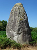
<< Our Photo Pages >> Menhir de Bos Calers - Standing Stone (Menhir) in France in Bretagne:Morbihan (56)
Submitted by holger_rix on Friday, 03 June 2016 Page Views: 1180
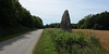
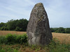
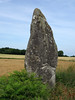
Neolithic and Bronze AgeSite Name: Menhir de Bos CalersCountry: France
NOTE: This site is 9.96 km away from the location you searched for.
Département: Bretagne:Morbihan (56) Type: Standing Stone (Menhir)
Nearest Town: Ploërmel Nearest Village: Ménéac
Latitude: 48.149565N Longitude: 2.508741W
Condition:
| 5 | Perfect |
| 4 | Almost Perfect |
| 3 | Reasonable but with some damage |
| 2 | Ruined but still recognisable as an ancient site |
| 1 | Pretty much destroyed, possibly visible as crop marks |
| 0 | No data. |
| -1 | Completely destroyed |
| 5 | Superb |
| 4 | Good |
| 3 | Ordinary |
| 2 | Not Good |
| 1 | Awful |
| 0 | No data. |
| 5 | Can be driven to, probably with disabled access |
| 4 | Short walk on a footpath |
| 3 | Requiring a bit more of a walk |
| 2 | A long walk |
| 1 | In the middle of nowhere, a nightmare to find |
| 0 | No data. |
| 5 | co-ordinates taken by GPS or official recorded co-ordinates |
| 4 | co-ordinates scaled from a detailed map |
| 3 | co-ordinates scaled from a bad map |
| 2 | co-ordinates of the nearest village |
| 1 | co-ordinates of the nearest town |
| 0 | no data |
Be the first person to rate this site - see the 'Contribute!' box in the right hand menu.
Internal Links:
External Links:
I have visited· I would like to visit
Timetrails visited on 2nd May 2021 - their rating: Cond: 3 Amb: 5 Access: 3
")
D 175, Ménéac, Ploërmel, Morbihan, Brittany
Source: T4T35
Wikipedia article
Liste des sites mégalithiques du Morbihan
Information and Pictures:
www.t4t35.fr/
You may be viewing yesterday's version of this page. To see the most up to date information please register for a free account.
Do not use the above information on other web sites or publications without permission of the contributor.
Nearby Images from Flickr
The above images may not be of the site on this page, but were taken nearby. They are loaded from Flickr so please click on them for image credits.
Click here to see more info for this site
Nearby sites
Click here to view sites on an interactive map of the areaKey: Red: member's photo, Blue: 3rd party photo, Yellow: other image, Green: no photo - please go there and take one, Grey: site destroyed
Download sites to:
KML (Google Earth)
GPX (GPS waypoints)
CSV (Garmin/Navman)
CSV (Excel)
To unlock full downloads you need to sign up as a Contributory Member. Otherwise downloads are limited to 50 sites.
Turn off the page maps and other distractions
Nearby sites listing. In the following links * = Image available
1.5km NNE 31° Allée Couverte de Ville-Menot* Passage Grave
2.2km ESE 107° Menhir de Camblot* Standing Stone (Menhir)
3.4km NE 47° Pellionnaie menhir* Standing Stone (Menhir)
3.6km ESE 107° Menhir de Chauchix* Standing Stone (Menhir)
5.2km ESE 107° Menhir de Bellouan* Standing Stone (Menhir)
13.9km NNE 15° Menhir de Perfaux B* Standing Stone (Menhir)
14.0km NNE 15° Menhir de Perfaux C* Standing Stone (Menhir)
14.0km NNE 17° Menhir de Perfaux D* Standing Stone (Menhir)
14.1km NNE 12° Martinais* Standing Stone (Menhir)
14.2km NNE 16° Menhir de Perfaux A* Standing Stone (Menhir)
14.2km NNE 16° Menhir de Perfaux E* Standing Stone (Menhir)
14.5km N 355° Allée Couverte de La Hautière Passage Grave
14.6km NNE 19° Menhir de Brigneul* Standing Stone (Menhir)
14.7km N 8° Allée couverte du Rocher (Saint-Jacut-du-Mené) Passage Grave
15.8km NNE 19° Langourla menhir* Standing Stone (Menhir)
16.9km SW 220° Camp Romain du Haut-Bodinais Ancient Village or Settlement
18.1km NW 319° Menhir du Saut Thébault* Standing Stone (Menhir)
18.2km ESE 114° Dolmen dit Pierre des Champs-Morgan Burial Chamber or Dolmen
19.0km NW 325° Tumulus dit la Bosse du Diable Hillfort
19.2km N 357° Pierres de Crokélien* Rock Outcrop
19.9km SSW 204° Fountain Notre Dame Des Fleurs, Lanouée* Holy Well or Sacred Spring
20.2km NW 304° Alignement de Port-Coeprenet Stone Row / Alignment
20.2km NE 55° Menhir de la Glinaie Standing Stone (Menhir)
20.5km N 352° Dolmen de Saint-Maudez Burial Chamber or Dolmen
20.6km N 3° Allée couverte des Meurtiaux* Passage Grave
View more nearby sites and additional images


 We would like to know more about this location. Please feel free to add a brief description and any relevant information in your own language.
 Wir möchten mehr über diese Stätte erfahren. Bitte zögern Sie nicht, eine kurze Beschreibung und relevante Informationen in Deutsch hinzuzufügen.
 Nous aimerions en savoir encore un peu sur les lieux. S'il vous plaît n'hesitez pas à ajouter une courte description et tous les renseignements pertinents dans votre propre langue.
 Quisieramos informarnos un poco más de las lugares. No dude en añadir una breve descripción y otros datos relevantes en su propio idioma.