


<< Our Photo Pages >> Mertoun Kirk (St Boswells) - Sculptured Stone in Scotland in Scottish Borders
Submitted by Anne T on Saturday, 07 October 2017 Page Views: 2007
Multi-periodSite Name: Mertoun Kirk (St Boswells) Alternative Name: Mertoun Parish ChurchCountry: Scotland
NOTE: This site is 1.008 km away from the location you searched for.
County: Scottish Borders Type: Sculptured Stone
Nearest Town: St Boswells
Map Ref: NT6155231821
Latitude: 55.578516N Longitude: 2.611397W
Condition:
| 5 | Perfect |
| 4 | Almost Perfect |
| 3 | Reasonable but with some damage |
| 2 | Ruined but still recognisable as an ancient site |
| 1 | Pretty much destroyed, possibly visible as crop marks |
| 0 | No data. |
| -1 | Completely destroyed |
| 5 | Superb |
| 4 | Good |
| 3 | Ordinary |
| 2 | Not Good |
| 1 | Awful |
| 0 | No data. |
| 5 | Can be driven to, probably with disabled access |
| 4 | Short walk on a footpath |
| 3 | Requiring a bit more of a walk |
| 2 | A long walk |
| 1 | In the middle of nowhere, a nightmare to find |
| 0 | No data. |
| 5 | co-ordinates taken by GPS or official recorded co-ordinates |
| 4 | co-ordinates scaled from a detailed map |
| 3 | co-ordinates scaled from a bad map |
| 2 | co-ordinates of the nearest village |
| 1 | co-ordinates of the nearest town |
| 0 | no data |
Internal Links:
External Links:
I have visited· I would like to visit
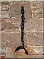
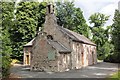
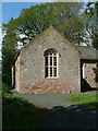
Anne T visited on 24th Sep 2017 - their rating: Cond: 3 Amb: 3 Access: 5 Mertoun Kirk, incised stone: The church lies in the grounds of Mertoun House, which lies almost directly north, across a bend in the River Tweed, from Maxton with its Burgh Cross. To approach the church, we had to follow the signs up the single track road to the house; the church is just before you reach the house. There were other Roman fragments built into seats in the gardens just outside the house, but we needed to pay to get in the house, and there was only half an hour before it shut for the evening. Fortunately, we were able to park outside the church, next to the mounting block, and walked around this very hidden, almost secretive church.
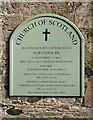
The church itself was locked, and we couldn’t get in. Whilst Canmore gives no date for the stone, the fragment looks older than the church which was built in 1658 and restored in 1820 and 1898.
 (PID:171957)")
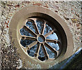
Recorded as Canmore ID 57277, this small church is almost hidden in a dense wood, just to the west of Mertoun House, across the River Tweed, and almost directly north of St. Boswells.
The church itself was built in 1658AD and again restored in 1898. Tucked away on the east wall of the modern extension at the north east side of the church is what we took to be the remains of an old cross shaft with plain interlace ornament on it. This stone measures just over 1 ft long by 6 ins deep. The church have chosen a lovely location for this stone (not), displaying it almost above the very large oil tank for the central heating. No date has been given for this stone, and it is not mentioned in the 'History of Mertoun Kirk' (Mertoun Kirk website).
You may be viewing yesterday's version of this page. To see the most up to date information please register for a free account.
Do not use the above information on other web sites or publications without permission of the contributor.
Nearby Images from Geograph Britain and Ireland:
©2013(licence)
©2013(licence)
©2013(licence)
©2013(licence)
©2010(licence)
The above images may not be of the site on this page, they are loaded from Geograph.
Please Submit an Image of this site or go out and take one for us!
Click here to see more info for this site
Nearby sites
Key: Red: member's photo, Blue: 3rd party photo, Yellow: other image, Green: no photo - please go there and take one, Grey: site destroyed
Download sites to:
KML (Google Earth)
GPX (GPS waypoints)
CSV (Garmin/Navman)
CSV (Excel)
To unlock full downloads you need to sign up as a Contributory Member. Otherwise downloads are limited to 50 sites.
Turn off the page maps and other distractions
Nearby sites listing. In the following links * = Image available
1.3km SW 223° Crystal Well (Benrig)* Holy Well or Sacred Spring (NT6064030847)
1.6km SW 215° St Boswell's Old Church* Ancient Cross (NT6063730533)
1.6km S 187° Maxton Burgh (St Boswells)* Ancient Cross (NT61333020)
1.6km SSW 211° Hier Well (Benrig)* Holy Well or Sacred Spring (NT60703042)
2.1km WNW 290° Font Stone (Dryburgh)* Ancient Cross (NT59543258)
4.2km N 4° Brothers' Stones* Standing Stones (NT61903600)
4.4km N 7° Cow Stone (Scottish Borders)* Standing Stone (Menhir) (NT62163620)
5.2km WNW 299° Trimontium* Ancient Village or Settlement (NT57033435)
5.3km WNW 289° Rhymer's Stone (Melrose)* Marker Stone (NT5651833592)
5.8km E 93° The Law (Scottish Borders) Artificial Mound (NT6735831447)
6.1km ESE 122° Fairnington Stone Circle (NT667285)
6.1km SSE 162° Harrietsfield Standing Stone (Menhir) (NT63442599)
6.2km W 279° Eildon Hill North* Hillfort (NT55453280)
7.0km S 175° Ancrum Old Church* Sculptured Stone (NT6215024885)
7.0km S 173° Castle Hill (Ancrum)* Hillfort (NT6239424909)
7.3km SSE 155° Woodside (Crailing) Standing Stone (Menhir) (NT64552517)
8.1km NNW 346° Purveshaugh* Standing Stone (Menhir) (NT59663973)
8.2km SSE 162° Harestanes (Ancrum) Stone Circle (NT640240)
8.2km SSE 161° Harestanes (Ancrum) Stone Circle (NT641240)
8.4km SE 136° Nisbet 2 Sculptured Stone (NT67322572)
10.2km SE 134° Crailing Cross* Ancient Cross (NT6879724676)
11.7km ESE 115° Haughhead Kip (Eckford)* Sculptured Stone (NT72212683)
11.9km SSE 162° Jedburgh Rock Art Rock Art (NT651204)
12.0km SSE 163° Jedburgh Ancient Christian Stones* Ancient Cross (NT65052038)
12.6km ENE 63° Piper's Grave Cists Cist (NT72923739)
View more nearby sites and additional images


 We would like to know more about this location. Please feel free to add a brief description and any relevant information in your own language.
 Wir möchten mehr über diese Stätte erfahren. Bitte zögern Sie nicht, eine kurze Beschreibung und relevante Informationen in Deutsch hinzuzufügen.
 Nous aimerions en savoir encore un peu sur les lieux. S'il vous plaît n'hesitez pas à ajouter une courte description et tous les renseignements pertinents dans votre propre langue.
 Quisieramos informarnos un poco más de las lugares. No dude en añadir una breve descripción y otros datos relevantes en su propio idioma.