


<< Our Photo Pages >> Stèle de Guehénno - Standing Stone (Menhir) in France in Bretagne:Morbihan (56)
Submitted by Ogham on Friday, 21 August 2015 Page Views: 1166
Neolithic and Bronze AgeSite Name: Stèle de GuehénnoCountry: France
NOTE: This site is 3.055 km away from the location you searched for.
Département: Bretagne:Morbihan (56) Type: Standing Stone (Menhir)
Nearest Town: Pontivy Nearest Village: Guehénno
Latitude: 47.891500N Longitude: 2.639117W
Condition:
| 5 | Perfect |
| 4 | Almost Perfect |
| 3 | Reasonable but with some damage |
| 2 | Ruined but still recognisable as an ancient site |
| 1 | Pretty much destroyed, possibly visible as crop marks |
| 0 | No data. |
| -1 | Completely destroyed |
| 5 | Superb |
| 4 | Good |
| 3 | Ordinary |
| 2 | Not Good |
| 1 | Awful |
| 0 | No data. |
| 5 | Can be driven to, probably with disabled access |
| 4 | Short walk on a footpath |
| 3 | Requiring a bit more of a walk |
| 2 | A long walk |
| 1 | In the middle of nowhere, a nightmare to find |
| 0 | No data. |
| 5 | co-ordinates taken by GPS or official recorded co-ordinates |
| 4 | co-ordinates scaled from a detailed map |
| 3 | co-ordinates scaled from a bad map |
| 2 | co-ordinates of the nearest village |
| 1 | co-ordinates of the nearest town |
| 0 | no data |
Internal Links:
External Links:
I have visited· I would like to visit
Ogham has visited here
")
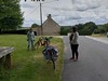
A small stele 1m in height, it is located by the parish close in the church yard.
The parish close, entered through a triumphal doorway, is a link between the living and dead. It is generally sited around the cemetery and comprises church, ossuary and Calvary. The latter is a characteristic Breton monument and follows on from the Christianised menhir and wayside cross.
As you approach the church the stele is to the right of the Calvary.
You may be viewing yesterday's version of this page. To see the most up to date information please register for a free account.
")
")
Do not use the above information on other web sites or publications without permission of the contributor.
Nearby Images from Flickr


The above images may not be of the site on this page, but were taken nearby. They are loaded from Flickr so please click on them for image credits.
Click here to see more info for this site
Nearby sites
Click here to view sites on an interactive map of the areaKey: Red: member's photo, Blue: 3rd party photo, Yellow: other image, Green: no photo - please go there and take one, Grey: site destroyed
Download sites to:
KML (Google Earth)
GPX (GPS waypoints)
CSV (Garmin/Navman)
CSV (Excel)
To unlock full downloads you need to sign up as a Contributory Member. Otherwise downloads are limited to 50 sites.
Turn off the page maps and other distractions
Nearby sites listing. In the following links * = Image available
4.6km SSW 195° Allée Couverte de Kersimon Passage Grave
5.7km NNW 330° Pierre de Buléon* Standing Stone (Menhir)
6.5km W 279° Coët-er-Rui Dolmen* Burial Chamber or Dolmen
7.7km NNW 329° Fontaine Saint-Armel* Holy Well or Sacred Spring
8.1km SW 230° St Jean-Brévelay stèle* Standing Stone (Menhir)
8.1km SW 230° Roh Coh Couët menhir* Standing Stone (Menhir)
8.1km SW 230° St Jean-Brévelay menhir* Standing Stone (Menhir)
8.6km S 182° Roche de Migourdy* Burial Chamber or Dolmen
9.0km SW 234° Kerivo Menhir* Standing Stone (Menhir)
9.1km SW 217° Keruzan menhir Standing Stone (Menhir)
9.5km SW 216° Dolmen de Keruzan* Burial Chamber or Dolmen
10.0km N 349° La Haye tumulus* Chambered Tomb
10.1km NW 322° Calvaire et fontaine de Saint-Fiacre* Holy Well or Sacred Spring
10.3km SSW 204° Menguen Lanvaux menhir* Standing Stone (Menhir)
10.3km S 171° Allée Couverte du Prés-du-Parc Passage Grave
10.4km SW 221° Kerarmel Menhir* Standing Stone (Menhir)
10.4km SSW 202° Allée couverte de Menguen-Lanvaux* Passage Grave
10.5km SW 227° Lann Doaur menhir* Standing Stone (Menhir)
10.6km S 190° Allée Couverte de Kerlano Passage Grave
10.6km SSE 162° Grande Villeneuve Menhir* Standing Stone (Menhir)
10.7km N 8° Fountain Notre Dame Des Fleurs, Lanouée* Holy Well or Sacred Spring
10.8km SSE 168° Dolmen Prés du Parc Burial Chamber or Dolmen
11.0km SW 220° La Moustoir stèle* Standing Stone (Menhir)
11.3km SSE 157° Dolmen du Stade Burial Chamber or Dolmen
11.5km SW 223° Kerherne-Bodunan dolmen* Passage Grave
View more nearby sites and additional images


 We would like to know more about this location. Please feel free to add a brief description and any relevant information in your own language.
 Wir möchten mehr über diese Stätte erfahren. Bitte zögern Sie nicht, eine kurze Beschreibung und relevante Informationen in Deutsch hinzuzufügen.
 Nous aimerions en savoir encore un peu sur les lieux. S'il vous plaît n'hesitez pas à ajouter une courte description et tous les renseignements pertinents dans votre propre langue.
 Quisieramos informarnos un poco más de las lugares. No dude en añadir una breve descripción y otros datos relevantes en su propio idioma.