


<< Our Photo Pages >> Chewton Mendip Cross - Ancient Cross in England in Somerset
Submitted by dooclay on Sunday, 14 May 2023 Page Views: 277
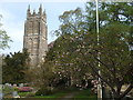
Early Medieval (Dark Age)Site Name: Chewton Mendip CrossCountry: England
NOTE: This site is 0.883 km away from the location you searched for.
County: Somerset Type: Ancient Cross
Nearest Town: Bristol Nearest Village: Chewton Mendip
Map Ref: ST5962353136
Latitude: 51.275930N Longitude: 2.580229W
Condition:
| 5 | Perfect |
| 4 | Almost Perfect |
| 3 | Reasonable but with some damage |
| 2 | Ruined but still recognisable as an ancient site |
| 1 | Pretty much destroyed, possibly visible as crop marks |
| 0 | No data. |
| -1 | Completely destroyed |
| 5 | Superb |
| 4 | Good |
| 3 | Ordinary |
| 2 | Not Good |
| 1 | Awful |
| 0 | No data. |
| 5 | Can be driven to, probably with disabled access |
| 4 | Short walk on a footpath |
| 3 | Requiring a bit more of a walk |
| 2 | A long walk |
| 1 | In the middle of nowhere, a nightmare to find |
| 0 | No data. |
| 5 | co-ordinates taken by GPS or official recorded co-ordinates |
| 4 | co-ordinates scaled from a detailed map |
| 3 | co-ordinates scaled from a bad map |
| 2 | co-ordinates of the nearest village |
| 1 | co-ordinates of the nearest town |
| 0 | no data |
Internal Links:
External Links:
")
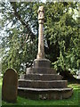
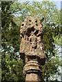
From Somerset HER:
One of the four rare C14 canopied crosses of Somerset, is situated to the W of the S porch of Chewton Mendip church. The head was blown down some 20 years ago, and when replaced was much defaced.
You may be viewing yesterday's version of this page. To see the most up to date information please register for a free account.
Do not use the above information on other web sites or publications without permission of the contributor.
Nearby Images from Geograph Britain and Ireland:
©2019(licence)
©2019(licence)
©2019(licence)
©2018(licence)
©2019(licence)
The above images may not be of the site on this page, they are loaded from Geograph.
Please Submit an Image of this site or go out and take one for us!
Click here to see more info for this site
Nearby sites
Key: Red: member's photo, Blue: 3rd party photo, Yellow: other image, Green: no photo - please go there and take one, Grey: site destroyed
Download sites to:
KML (Google Earth)
GPX (GPS waypoints)
CSV (Garmin/Navman)
CSV (Excel)
To unlock full downloads you need to sign up as a Contributory Member. Otherwise downloads are limited to 50 sites.
Turn off the page maps and other distractions
Nearby sites listing. In the following links * = Image available
474m E 100° Lime House Long Barrow* Long Barrow (ST60095305)
508m ENE 66° Barrow House Farm Long Barrow * Chambered Tomb (ST60095334)
2.8km ENE 65° Ston Easton Barrow* Round Barrow(s) (ST622543)
4.0km S 177° Whitnell Corner Barrows* Barrow Cemetery (ST5982849096)
4.3km ESE 122° Three Tuns Tumuli* Barrow Cemetery (ST6324250870)
4.8km SW 230° Hunter's Lodge Inn Barrow* Round Barrow(s) (ST559501)
5.0km SW 228° Drove Cottage Henge* Henge (ST559498)
5.1km SE 127° Blackers Hill Promontory Fort* Hillfort (ST6364850045)
5.1km W 263° Castle Farm Long Barrow* Long Barrow (ST54525255)
5.4km W 274° Priddy Circles Unfinished N* Henge (ST54215355)
5.5km NNW 344° Burledge Hillfort* Hillfort (ST582584)
5.5km W 268° Priddy Circles N* Henge (ST54095302)
5.5km SW 216° Pen Hill Longbarrow* Long Barrow (ST563487)
5.5km ESE 108° Fry's Well* Holy Well or Sacred Spring (ST649514)
5.6km W 266° Priddy Circles C* Henge (ST54015279)
5.6km WSW 245° Fair Lady Well* Holy Well or Sacred Spring (ST54515079)
5.6km W 266° Priddy Circles* Henge (ST54005280)
5.7km W 264° Priddy Circles S* Henge (ST53945255)
5.8km W 259° Ashen Hill Barrows* Barrow Cemetery (ST53905205)
5.9km WSW 253° Priddy Nine Barrows* Barrow Cemetery (ST53925149)
6.0km W 279° Pool Farm Cist* Rock Art (ST53745415)
6.1km SSE 167° Maesbury Castle* Hillfort (ST610472)
6.7km WNW 283° Wright's Piece barrows (N)* Barrow Cemetery (ST531547)
7.0km W 281° Wright's Piece barrows (S)* Barrow Cemetery (ST527545)
7.2km WSW 256° Priddy Church Barrows* Barrow Cemetery (ST526514)
View more nearby sites and additional images


 We would like to know more about this location. Please feel free to add a brief description and any relevant information in your own language.
 Wir möchten mehr über diese Stätte erfahren. Bitte zögern Sie nicht, eine kurze Beschreibung und relevante Informationen in Deutsch hinzuzufügen.
 Nous aimerions en savoir encore un peu sur les lieux. S'il vous plaît n'hesitez pas à ajouter une courte description et tous les renseignements pertinents dans votre propre langue.
 Quisieramos informarnos un poco más de las lugares. No dude en añadir una breve descripción y otros datos relevantes en su propio idioma.