

<< Our Photo Pages >> Three Tuns Tumuli - Barrow Cemetery in England in Somerset
Submitted by dooclay on Sunday, 07 August 2022 Page Views: 318
Neolithic and Bronze AgeSite Name: Three Tuns Tumuli Alternative Name: 23294: Barrow, NW of Blackers Hill, ChilcomptonCountry: England County: Somerset Type: Barrow Cemetery
Nearest Village: Gurney Slade
Map Ref: ST6324250870
Latitude: 51.255801N Longitude: 2.528116W
Condition:
| 5 | Perfect |
| 4 | Almost Perfect |
| 3 | Reasonable but with some damage |
| 2 | Ruined but still recognisable as an ancient site |
| 1 | Pretty much destroyed, possibly visible as crop marks |
| 0 | No data. |
| -1 | Completely destroyed |
| 5 | Superb |
| 4 | Good |
| 3 | Ordinary |
| 2 | Not Good |
| 1 | Awful |
| 0 | No data. |
| 5 | Can be driven to, probably with disabled access |
| 4 | Short walk on a footpath |
| 3 | Requiring a bit more of a walk |
| 2 | A long walk |
| 1 | In the middle of nowhere, a nightmare to find |
| 0 | No data. |
| 5 | co-ordinates taken by GPS or official recorded co-ordinates |
| 4 | co-ordinates scaled from a detailed map |
| 3 | co-ordinates scaled from a bad map |
| 2 | co-ordinates of the nearest village |
| 1 | co-ordinates of the nearest town |
| 0 | no data |
Internal Links:
External Links:
")
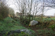
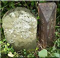
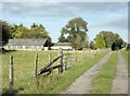
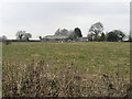
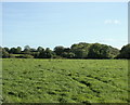
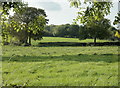
Grid reference refers to 1 of 4 barrows (23294) noted to exist here, this one being that nearest to Three Tuns Farm. Two south of the road were behind a hedge and covered in Maize and so not visible whilst the fourth has apparently been ploughed out.
You may be viewing yesterday's version of this page. To see the most up to date information please register for a free account.
Do not use the above information on other web sites or publications without permission of the contributor.
Nearby Images from Geograph Britain and Ireland:
©2019(licence)
©2009(licence)
©2006(licence)
©2009(licence)
©2009(licence)
The above images may not be of the site on this page, they are loaded from Geograph.
Please Submit an Image of this site or go out and take one for us!
Click here to see more info for this site
Nearby sites
Key: Red: member's photo, Blue: 3rd party photo, Yellow: other image, Green: no photo - please go there and take one, Grey: site destroyed
Download sites to:
KML (Google Earth)
GPX (GPS waypoints)
CSV (Garmin/Navman)
CSV (Excel)
To unlock full downloads you need to sign up as a Contributory Member. Otherwise downloads are limited to 50 sites.
Turn off the page maps and other distractions
Nearby sites listing. In the following links * = Image available
919m SSE 153° Blackers Hill Promontory Fort* Hillfort (ST6364850045)
1.7km ENE 72° Fry's Well* Holy Well or Sacred Spring (ST649514)
3.4km ESE 116° Stratton on the Fosse Artificial Mound (ST66314938)
3.6km NNW 343° Ston Easton Barrow* Round Barrow(s) (ST622543)
3.8km NW 304° Lime House Long Barrow* Long Barrow (ST60095305)
3.8km WSW 242° Whitnell Corner Barrows* Barrow Cemetery (ST5982849096)
3.9km SE 142° Fairy Cave Cave or Rock Shelter (ST65654775)
4.0km NW 308° Barrow House Farm Long Barrow * Chambered Tomb (ST60095334)
4.3km WNW 302° Chewton Mendip Cross* Ancient Cross (ST5962353136)
4.3km SSW 211° Maesbury Castle* Hillfort (ST610472)
4.6km E 85° Giants Grave, Southmead* Long Barrow (ST678512)
4.6km E 84° Charmborough Hill Chambered Tomb (ST678513)
4.7km S 177° Beacon Hill (Oakhill) Barrows* Barrow Cemetery (ST63484616)
6.5km SSW 214° Crapnell Stone Circle (ST596455)
6.6km ENE 58° Jubilee Field Round Barrow(s) (ST68895436)
7.3km WSW 252° Pen Hill Longbarrow* Long Barrow (ST563487)
7.4km W 264° Hunter's Lodge Inn Barrow* Round Barrow(s) (ST559501)
7.4km W 261° Drove Cottage Henge* Henge (ST559498)
7.5km SSE 167° Doulting Quarries barrow* Modern Stone Circle etc (ST64824353)
7.8km S 169° St Aldhelm's Well* Holy Well or Sacred Spring (ST647432)
7.8km NE 47° Roundhill Barrow* Round Barrow(s) (ST69005616)
7.8km NE 46° Rowberrow Field Barrow Round Barrow(s) (ST68925630)
8.3km SW 230° King's Castle (Wells) Ancient Village or Settlement (ST568456)
8.5km SSE 162° West Cranmore Round Barrows* Barrow Cemetery (ST65844274)
8.7km W 269° Fair Lady Well* Holy Well or Sacred Spring (ST54515079)
View more nearby sites and additional images


 We would like to know more about this location. Please feel free to add a brief description and any relevant information in your own language.
 Wir möchten mehr über diese Stätte erfahren. Bitte zögern Sie nicht, eine kurze Beschreibung und relevante Informationen in Deutsch hinzuzufügen.
 Nous aimerions en savoir encore un peu sur les lieux. S'il vous plaît n'hesitez pas à ajouter une courte description et tous les renseignements pertinents dans votre propre langue.
 Quisieramos informarnos un poco más de las lugares. No dude en añadir una breve descripción y otros datos relevantes en su propio idioma.