


<< Text Pages >> The Doffcocker Cross - Ancient Cross in England in Greater Manchester
Submitted by Sunny100 on Sunday, 01 January 2012 Page Views: 6223
Early Medieval (Dark Age)Site Name: The Doffcocker Cross Alternative Name: St Jame's Church CrossCountry: England
NOTE: This site is 0.932 km away from the location you searched for.
County: Greater Manchester Type: Ancient Cross
Nearest Town: Bolton Nearest Village: Doffcocker
Map Ref: SD6846411027
Latitude: 53.594861N Longitude: 2.477948W
Condition:
| 5 | Perfect |
| 4 | Almost Perfect |
| 3 | Reasonable but with some damage |
| 2 | Ruined but still recognisable as an ancient site |
| 1 | Pretty much destroyed, possibly visible as crop marks |
| 0 | No data. |
| -1 | Completely destroyed |
| 5 | Superb |
| 4 | Good |
| 3 | Ordinary |
| 2 | Not Good |
| 1 | Awful |
| 0 | No data. |
| 5 | Can be driven to, probably with disabled access |
| 4 | Short walk on a footpath |
| 3 | Requiring a bit more of a walk |
| 2 | A long walk |
| 1 | In the middle of nowhere, a nightmare to find |
| 0 | No data. |
| 5 | co-ordinates taken by GPS or official recorded co-ordinates |
| 4 | co-ordinates scaled from a detailed map |
| 3 | co-ordinates scaled from a bad map |
| 2 | co-ordinates of the nearest village |
| 1 | co-ordinates of the nearest town |
| 0 | no data |
Internal Links:
External Links:
The Doffcocker cross, an Anglo-Saxon monument, stands just within the precint of the Roman Catholic church of St James the Great on Bowland Drive at Johnson Fold, few miles north-west of Bolton city centre. The A58 road is just a little north of the church. This odd-shaped cross is best viewed from Montserrat Road at the other side of the church. There is a well-tended little garden around the base of the cross.
This tall slender cross is said to be around 7 feet tall and although the age is unknown, the thinking is that it dates from somewhere between the 7th-11th century CE. At some point it was being used as a bridge crossing a nearby stream but, thankfully it was brought here for safety because it was recognised as being an ancient monument. The three-armed stumpy cross-head has been crudely fashioned, but the shaft is long and slender. There are some faint traces of carving on the edge and front-side, similar to notches - perhaps part of a very worn inscription or some Saxon carving ?
The cross-head is similar to 'The Paulinus Cross' at Kemple End on Longridge Fell in Lancashire, and the shaft much the same as that of 'The Burnley Cross' in Lancashire. So this cross must also be considered to be one set up as a preaching cross by St Paulinus in the 7th century CE.
You may be viewing yesterday's version of this page. To see the most up to date information please register for a free account.
")
")
")
")
")
")
Do not use the above information on other web sites or publications without permission of the contributor.
Click here to see more info for this site
Nearby sites
Key: Red: member's photo, Blue: 3rd party photo, Yellow: other image, Green: no photo - please go there and take one, Grey: site destroyed
Download sites to:
KML (Google Earth)
GPX (GPS waypoints)
CSV (Garmin/Navman)
CSV (Excel)
To unlock full downloads you need to sign up as a Contributory Member. Otherwise downloads are limited to 50 sites.
Turn off the page maps and other distractions
Nearby sites listing. In the following links * = Image available
678m NNW 327° Thurstones Row Stone Row / Alignment (SD681116)
1.0km NW 319° The Thurstones Rock Art (SD678118)
1.9km E 82° Toothill Long Barrow* Long Barrow (SD704113)
2.0km N 4° Priests Crown* Long Barrow (SD68621307)
2.1km NNW 344° Brown Stones* Stone Row / Alignment (SD679130)
2.4km N 353° Moortop Barrows* Round Barrow(s) (SD682134)
2.5km NW 323° Sugarloaf Standing Stone* Standing Stone (Menhir) (SD66981304)
2.5km NW 312° Burnt Edge* Stone Row / Alignment (SD666127)
2.5km WNW 300° Montcliffe Cairn (SD663123)
2.5km NW 321° Sugarloaf Hill Barrow* Round Barrow(s) (SD66911300)
2.6km WNW 302° Adam Hill* Cairn (SD663124)
2.6km N 5° Horrocks Moor Barrow* Artificial Mound (SD687136)
2.9km NW 318° Holden's Farm Ring Cairn (SD665132)
3.3km NNW 333° Counting Hill Ringcairn Ring Cairn (SD670140)
3.3km NNW 337° Counting Hill Row* Stone Row / Alignment (SD672141)
3.6km ESE 123° Bolton Museum* Museum (SD715090)
3.7km NW 308° Two Lads (Rivington)* Cairn (SD65541330)
4.0km ESE 115° St Peter's Church (Bolton)* Ancient Cross (SD721093)
4.4km ESE 117° Haulgh (Bolton) Cairn (SD72420899)
4.9km NW 324° Winter Hill Cairn* Cairn (SD65581499)
5.0km WNW 304° Rivington Pike* Cairn (SD64311382)
5.5km NW 316° Noon Hill Slack* Cairn (SD64691499)
5.8km NNE 33° Cheetham Close* Stone Circle (SD71631586)
6.6km E 91° Dry Hillock Marker Stone* Marker Stone (SD7511310830)
6.8km WNW 287° Grimeford Headless Cross* Ancient Cross (SD6190113018)
View more nearby sites and additional images


 We would like to know more about this location. Please feel free to add a brief description and any relevant information in your own language.
 Wir möchten mehr über diese Stätte erfahren. Bitte zögern Sie nicht, eine kurze Beschreibung und relevante Informationen in Deutsch hinzuzufügen.
 Nous aimerions en savoir encore un peu sur les lieux. S'il vous plaît n'hesitez pas à ajouter une courte description et tous les renseignements pertinents dans votre propre langue.
 Quisieramos informarnos un poco más de las lugares. No dude en añadir una breve descripción y otros datos relevantes en su propio idioma.
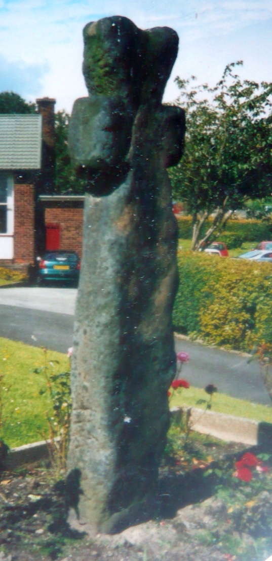