


<< Our Photo Pages >> Robin Hood's Well, Haslingden - Holy Well or Sacred Spring in England in Lancashire
Submitted by coldrum on Monday, 18 October 2010 Page Views: 6609
Springs and Holy WellsSite Name: Robin Hood's Well, HaslingdenCountry: England
NOTE: This site is 2.02 km away from the location you searched for.
County: Lancashire Type: Holy Well or Sacred Spring
Map Ref: SD77861954
Latitude: 53.671859N Longitude: 2.336596W
Condition:
| 5 | Perfect |
| 4 | Almost Perfect |
| 3 | Reasonable but with some damage |
| 2 | Ruined but still recognisable as an ancient site |
| 1 | Pretty much destroyed, possibly visible as crop marks |
| 0 | No data. |
| -1 | Completely destroyed |
| 5 | Superb |
| 4 | Good |
| 3 | Ordinary |
| 2 | Not Good |
| 1 | Awful |
| 0 | No data. |
| 5 | Can be driven to, probably with disabled access |
| 4 | Short walk on a footpath |
| 3 | Requiring a bit more of a walk |
| 2 | A long walk |
| 1 | In the middle of nowhere, a nightmare to find |
| 0 | No data. |
| 5 | co-ordinates taken by GPS or official recorded co-ordinates |
| 4 | co-ordinates scaled from a detailed map |
| 3 | co-ordinates scaled from a bad map |
| 2 | co-ordinates of the nearest village |
| 1 | co-ordinates of the nearest town |
| 0 | no data |
Be the first person to rate this site - see the 'Contribute!' box in the right hand menu.
Internal Links:
External Links:
")
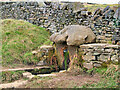
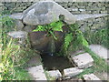
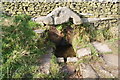
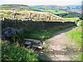
For more information see Pastscape Monument No. 44289, which tells us: "Robin Hood's Well is covered by a pyramidal sandstone block 1m square with water-worn hollows. The cover is supported on its E side by a flagstone and on its W by the stonework of a wall, thus raising it to a height of 0.8m from the ground. From beneath this cover a spring flows into a trough 1m square made of sandstone blocks set flush into the ground. The water in this trough then overflows into a soak-away."
The Journal of Antiquities also includes an entry for Robin Hood’s Well, Helmshore, Lancashire, which includes directions for finding this well, together with photographs, a description and a list of reference sources for more information.
The Journal adds "There are no records to say that Robin Hood’s Well ever had healing powers, or to it being a sacred spring, but it must have had some holiness attributed to it by the monks and pilgrims who visited it and drank of its waters back in the mists of time". The well is sited 1 mile to the north of Pilgrim's Cross on Holcombe Moor, on route to Whalley.
You may be viewing yesterday's version of this page. To see the most up to date information please register for a free account.
")
")
")
Do not use the above information on other web sites or publications without permission of the contributor.
Nearby Images from Geograph Britain and Ireland:
©2021(licence)
©2010(licence)
©2007(licence)
©2010(licence)
©2007(licence)
The above images may not be of the site on this page, they are loaded from Geograph.
Please Submit an Image of this site or go out and take one for us!
Click here to see more info for this site
Nearby sites
Key: Red: member's photo, Blue: 3rd party photo, Yellow: other image, Green: no photo - please go there and take one, Grey: site destroyed
Download sites to:
KML (Google Earth)
GPX (GPS waypoints)
CSV (Garmin/Navman)
CSV (Excel)
To unlock full downloads you need to sign up as a Contributory Member. Otherwise downloads are limited to 50 sites.
Turn off the page maps and other distractions
Nearby sites listing. In the following links * = Image available
4.2km SE 141° Whitelow* Cairn (SD80501626)
4.3km SSW 213° Carve Hill Low* Barrow Cemetery (SD755159)
4.9km S 191° Whippalow Hill* Barrow Cemetery (SD76921477)
4.9km NNW 345° Thirteen Stone Hill* Stone Circle (SD7665324273)
5.0km E 89° Waugh's Well (Edenfield) Holy Well or Sacred Spring (SD82871957)
5.1km SSW 200° Dodd Lee* Barrow Cemetery (SD76121476)
6.3km SSW 202° Affetside Cross (Lancashire) Ancient Cross (SD7546613689)
6.3km SSW 202° Affetside Cross (Bury)* Ancient Cross (SD7546613686)
6.9km SSE 164° Castlesteads (Walmersley)* Hillfort (SD797129)
7.1km NW 325° Cocker Cobb* Stone Circle (SD7385225360)
7.1km SE 130° Wind Hill Cheesden* Round Barrow(s) (SD8326214945)
7.2km WSW 239° Cheetham Close* Stone Circle (SD71631586)
7.6km SSE 147° Walmersley Golf Club stone* Modern Stone Circle etc (SD82011319)
8.3km W 278° White Hall* Round Barrow(s) (SD696208)
8.5km E 97° Hamer Hill* Stone Circle (SD863184)
8.5km SE 145° Castle Hill, Heywood Hillfort (SD827125)
9.0km N 9° May Hole Well (Hyndburn Moor)* Holy Well or Sacred Spring (SD7923528430)
9.1km SSW 197° Dry Hillock Marker Stone* Marker Stone (SD7511310830)
9.3km ESE 113° Hunger Hill Cairn* Cairn (SD864159)
9.7km ENE 68° Bacup Natural History Society Museum* Museum (SD869231)
9.8km ENE 61° Broadclough Dykes, Bacup, Lancashire* Misc. Earthwork (SD864243)
10.3km ESE 110° Lowe Dunishbooth Promontory Fort / Cliff Castle (SD8756115960)
10.5km ENE 68° Wyrd of Stake Moss* Modern Stone Circle etc (SD876235)
10.5km ESE 109° Lower Dunishbooth Promontory Fort / Cliff Castle (SD8779616025)
10.9km WSW 237° Horrocks Moor Barrow* Artificial Mound (SD687136)
View more nearby sites and additional images


 We would like to know more about this location. Please feel free to add a brief description and any relevant information in your own language.
 Wir möchten mehr über diese Stätte erfahren. Bitte zögern Sie nicht, eine kurze Beschreibung und relevante Informationen in Deutsch hinzuzufügen.
 Nous aimerions en savoir encore un peu sur les lieux. S'il vous plaît n'hesitez pas à ajouter une courte description et tous les renseignements pertinents dans votre propre langue.
 Quisieramos informarnos un poco más de las lugares. No dude en añadir una breve descripción y otros datos relevantes en su propio idioma.