

<< Our Photo Pages >> Outer Golden Pot (Otterburn) - Marker Stone in England in Northumberland
Submitted by Anne T on Monday, 29 May 2017 Page Views: 2369
Multi-periodSite Name: Outer Golden Pot (Otterburn)Country: England
NOTE: This site is 1.966 km away from the location you searched for.
County: Northumberland Type: Marker Stone
Nearest Town: Otterburn
Map Ref: NT8044207234
Latitude: 55.358722N Longitude: 2.310043W
Condition:
| 5 | Perfect |
| 4 | Almost Perfect |
| 3 | Reasonable but with some damage |
| 2 | Ruined but still recognisable as an ancient site |
| 1 | Pretty much destroyed, possibly visible as crop marks |
| 0 | No data. |
| -1 | Completely destroyed |
| 5 | Superb |
| 4 | Good |
| 3 | Ordinary |
| 2 | Not Good |
| 1 | Awful |
| 0 | No data. |
| 5 | Can be driven to, probably with disabled access |
| 4 | Short walk on a footpath |
| 3 | Requiring a bit more of a walk |
| 2 | A long walk |
| 1 | In the middle of nowhere, a nightmare to find |
| 0 | No data. |
| 5 | co-ordinates taken by GPS or official recorded co-ordinates |
| 4 | co-ordinates scaled from a detailed map |
| 3 | co-ordinates scaled from a bad map |
| 2 | co-ordinates of the nearest village |
| 1 | co-ordinates of the nearest town |
| 0 | no data |
Be the first person to rate this site - see the 'Contribute!' box in the right hand menu.
Internal Links:
External Links:
I have visited· I would like to visit
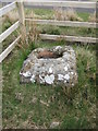
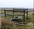
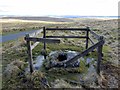
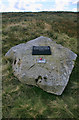
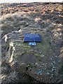
Anne T visited on 28th May 2017 - their rating: Cond: 2 Amb: 4 Access: 5 Outer Golden Pot (Otterburn): What stunning views across to Upper Coquetdale from here. No wonder the site is marked as a view point on the Otterburn Ranges Access Map. The fencing surrounding this Golden Pot has been broken on three sides, so it’s possible to appreciate its form more fully than the Middle Golden Pot.
The base is smaller than the Shitlington Cross but is about the same size as many of the Anglo Saxon Cross Bases we’ve seen in and around churches in North Yorkshire.
As I stepped back towards the road to photograph the base, I saw what looked like a cart track running diagonally up the hillside, crossing under the road and carrying on in a north-east/south-west direction. Andrew pointed out that if I moved a bit further over, I could see the second ditch, so this was the old course of Dere Street, now metalled and called ‘Roman Road’.
After stopping to photograph this stone, we went in search of Ridlees Cairn and Bushman’s Crag, to the south east of these intriguing cross bases.
 (PID:166246)")
There is some confusion as to what the 'Golden Pots' are. Five stones called Golden Pots are supposed to remain on the western side of the Roman Way (Dere Street) between Redesdale and Chew Green, but only three are listed: The Inner Golden Pot, Middle Golden Pot and Outer Golden Pot.
Originally thought to be Roman milestones, their shape is indicative of the base of a cross with socket hole. It was then thought that "the stone is possibly the remains of a late 14th century wayside cross", but a "a charter of 1228 mentions the "Goldingpottes' and "Goldingpot". It is probable that these stones were erected as boundary stones between the parish of Elsden and the chapelry of Halystone and as guides for the traveller." Given the position of these stones against the route of Dere Street, this would make sense.
Pastscape Monument No. 224 tells us that the block is made of sandstone and measures 3 ft long, 2ft 8ins wide with an off-set socket hole measuring 10ins by 16ins.
Confusingly Historic England has two entries for the Outer Golden Pot, both with the same grid reference. The first, Historic England List Entry 1041301 which says: "Crossbase, Medieval, possibly base of wayside funerary cross to Sir James Douglas, killed in Battle of Otterburn 1388. Sandstone."
The second entry is recorded as Historic England List Entry 1008282 which talks about wayside crosses in the designation, which were erected mostly from the 9th to 15th century. Their view is this is a 14th century wayside cross, put up to help travellers using Dere Street on their way between Corbridge and Newstead in Scotland.
Note to visitors: Check www.otterburnranges.co.uk for safe access times and a map & guide before travelling.
Note: Does anyone have any further information or comments about these intriguing stones?
You may be viewing yesterday's version of this page. To see the most up to date information please register for a free account.
 (PID:166245)")
 (PID:166244)")
 (PID:166247)")
Do not use the above information on other web sites or publications without permission of the contributor.
Nearby Images from Geograph Britain and Ireland:
©2020(licence)
©2016(licence)
©2013(licence)
©2010(licence)
©2008(licence)
The above images may not be of the site on this page, they are loaded from Geograph.
Please Submit an Image of this site or go out and take one for us!
Click here to see more info for this site
Nearby sites
Key: Red: member's photo, Blue: 3rd party photo, Yellow: other image, Green: no photo - please go there and take one, Grey: site destroyed
Download sites to:
KML (Google Earth)
GPX (GPS waypoints)
CSV (Garmin/Navman)
CSV (Excel)
To unlock full downloads you need to sign up as a Contributory Member. Otherwise downloads are limited to 50 sites.
Turn off the page maps and other distractions
Nearby sites listing. In the following links * = Image available
1.2km SE 139° Middle Golden Pot (Otterburn)* Marker Stone (NT8122006330)
2.0km SE 140° Inner Golden Pot (Otterburn)* Marker Stone (NT81730571)
4.8km SE 127° Ridlees Cairn* Cairn (NT8426204308)
5.2km SSW 194° Dour Hill Long Cairn c* Rock Art (NT7917002158)
5.2km SSW 193° Dour Hill Long Cairn b* Rock Art (NT7920302142)
5.2km SSW 193° Dour Hill Long Cairn d & e Rock Art (NT7920002140)
5.2km SSW 193° Dour Hill Long Cairn a Rock Art (NT7920302130)
5.3km SSW 193° Dour Hill (Rochester)* Chambered Cairn (NT79230212)
5.3km NW 321° Hindhope Hill Cairn* Cairn (NT7710811310)
5.4km NW 318° Hindhope Hill Hillfort* Hillfort (NT76811127)
5.6km WNW 300° Upper Hindhope* Standing Stones (NT75641008)
5.9km S 173° Bellshiel Law 1g Rock Art (NT8111801331)
6.1km S 173° Bellshiel Law 1b Rock Art (NT8116001204)
6.1km S 173° Bellshiel Law 1c Rock Art (NT8116001200)
6.1km NNW 340° Standard Knowe Cairn (NT78411300)
6.1km S 172° Bellshiel Law* Chambered Cairn (NT8131601173)
6.2km S 171° Bellshiel Law 1d Rock Art (NT8135801135)
6.2km S 171° Bellshiel Law 1e Rock Art (NT8138401127)
6.2km S 171° Bellshiel Law 1f Rock Art (NT8138001120)
6.2km S 175° Bellshiel Law 1a Rock Art (NT8094901039)
6.3km SSW 203° Byrness Forest Office Site Rock Art (NT7794101470)
6.4km NW 325° Woden Law* Hillfort (NT76771254)
6.7km S 171° Bellshiel Law 2d Rock Art (NT8150600619)
6.7km S 170° Bellshiel Law 2c Rock Art (NT8153400619)
6.7km S 170° Bellshiel Law 2b Rock Art (NT8154600609)
View more nearby sites and additional images


 We would like to know more about this location. Please feel free to add a brief description and any relevant information in your own language.
 Wir möchten mehr über diese Stätte erfahren. Bitte zögern Sie nicht, eine kurze Beschreibung und relevante Informationen in Deutsch hinzuzufügen.
 Nous aimerions en savoir encore un peu sur les lieux. S'il vous plaît n'hesitez pas à ajouter une courte description et tous les renseignements pertinents dans votre propre langue.
 Quisieramos informarnos un poco más de las lugares. No dude en añadir una breve descripción y otros datos relevantes en su propio idioma.